
Fayil:First Space-Based View of the Ozone Hole (8006648994).jpg

Hoton asali (pikisal 911 × 932, girman fayil: 282 KB, irin MIME: image/jpeg)
.jpg)
Taƙaici
| Bayani |
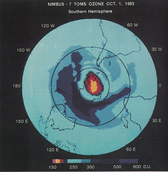
At an August 1985 meeting in Prague, atmospheric scientist Pawan Bhartia presented this satellite-based image that revealed for the first time the size and magnitude of the Antarctic ozone hole. The discovery ultimately led to the 1987 Montreal Protocol, a landmark international treaty designed to phase out ozone-depleting substances. Yesterday, Sept. 16,2012, marked 25 years since the treaty was opened for signatures. NASA satellites continue to provide clear snapshots of a generally stabilized Antarctic ozone hole as it cycles toward and away from its annual maximum depth by late September or early October. To read a Q&A about the discovery with NASA's Pawan Bhartia, visit: www.nasa.gov/topics/earth/features/bhartia-qa.html Credit: NASA NASA Goddard Space Flight Center enables NASA’s mission through four scientific endeavors: Earth Science, Heliophysics, Solar System Exploration, and Astrophysics. Goddard plays a leading role in NASA’s accomplishments by contributing compelling scientific knowledge to advance the Agency’s mission. Follow us on Twitter Like us on Facebook Find us on Instagram |
| Rana | |
| Masomi | First Space-Based View of the Ozone Hole |
| Marubucin | NASA Goddard Space Flight Center from Greenbelt, MD, USA |
Lasisi
- Za ka iya:
- a raba – dan kwafa, yadawa da aika aikin
- dan maimaita – dan daukar aikin
- A karkashin wannan sharuddan
- Jinginarwa – Dole ku bada jinjina da ta dace, samar da linki zuwa lasisin, da kuma bayyana ko kunyi sauyi. Zaku iya haka ta yadda ta dace, amma ba kowace hanya ba wanda zai nuna mai-lasisin yana goyon bayan ku ba ko goyon bayan amfanin da kuke yi ba.
| This image was originally posted to Flickr by NASA Goddard Photo and Video at https://flickr.com/photos/24662369@N07/8006648994. It was reviewed on 17 Satumba 2016 by FlickreviewR and was confirmed to be licensed under the terms of the cc-by-2.0. |
| This file is in the public domain in the United States because it was solely created by NASA. NASA copyright policy states that "NASA material is not protected by copyright unless noted". (See Template:PD-USGov, NASA copyright policy page or JPL Image Use Policy.) | ||
 |
Warnings:
|
Tarihin fayil
Ku latsa rana/lokaci ku ga fayil yadda yake a wannan lokaci
| Rana/Lokaci | Wadar sufa | Kusurwowi | Ma'aikaci | Bahasi | |
|---|---|---|---|---|---|
| na yanzu | 21:32, 17 Satumba 2016 | | 911 × 932 (282 KB) | Vanished Account Byeznhpyxeuztibuo | Transferred from Flickr via Flickr2Commons |
Amfani da fayil
Wadannan shafi na amfani wannan fayil:
Amfanin fayil a ko'ina
Wadannan sauran wikis suna amfani da fayil din anan
- Amfani a kan bn.wikipedia.org
- Amfani a kan en.wikipedia.org
- Amfani a kan tum.wikipedia.org
.jpg)