
File:Isle of Man map-en.svg

Size of this PNG preview of this SVG file: 654 × 600 pixels. Wasu yarjejeniyoyi: 262 × 240 pixels | 524 × 480 pixels | 838 × 768 pixels | 1,117 × 1,024 pixels | 2,234 × 2,048 pixels | 1,200 × 1,100 pixels.
Hoton asali (Fayil kin SVG, saƙar fikisal 1,200 x 1,100, girman fayil: 686 KB)

Taƙaici
| Bayani |
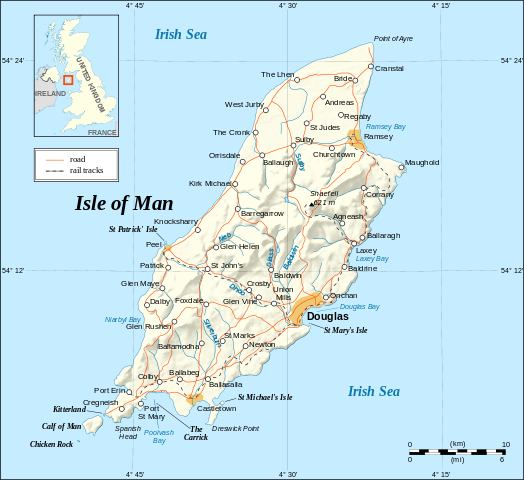
English: Map in English of the Isle of Man.
Note : The shaded relief is a raster image embedded in the SVG. Français : Carte en anglais de l'Île de Man. Note : Le relief ombré est une image bitmap incrustée dans le fichier SVG. UTM projection; WGS84 datum; shaded relief (composite image of N-W, W and N lightning positions); |
||
| Rana | |||
| Masomi |
Own work ;
|
||
| Marubucin | Eric Gaba (Sting - fr:Sting) | ||
| Izini (Sake amfani da wannan fayil) |
|
||
| Other versions |
[]
|


|
This SVG file contains embedded text that can be translated into your language, using any capable SVG editor, text editor or the SVG Translate tool. For more information see: About translating SVG files. |
Lasisi
I, the copyright holder of this work, hereby publish it under the following licenses:

|
An bada damar a kofa, a yaɗa/ko sauya wannan kundi ƙarƙashin Lasisin GNU ta kyauta, Fitarwa na 1.2 ko duk wani fitarwa da zai biyo baya daga Gidauniyar Samar da Software ta Kyauta; ba tare da sauyin sashe ba, babu Rubutun Fuskar gaban shafi, kuma babu Rubutun bayan shafi. Kofi na lasisin na nan an sanya sa aciki ƙarƙashin sashen GNU Free Documentation License. |
| Wannan fayil ɗin an bada lasisin shi ƙarƙashin Creative Commons Attribution-Share Alike 3.0 Unported lasisi. | ||
| ||
| This licensing tag was added to this file as part of the GFDL licensing update. |
This file is licensed under the Creative Commons Attribution-Share Alike 2.5 Generic, 2.0 Generic and 1.0 Generic license.
- Za ka iya:
- a raba – dan kwafa, yadawa da aika aikin
- dan maimaita – dan daukar aikin
- A karkashin wannan sharuddan
- Jinginarwa – Dole ku bada jinjina da ta dace, samar da linki zuwa lasisin, da kuma bayyana ko kunyi sauyi. Zaku iya haka ta yadda ta dace, amma ba kowace hanya ba wanda zai nuna mai-lasisin yana goyon bayan ku ba ko goyon bayan amfanin da kuke yi ba.
- Yada ahaka – Idan kuka maimaita, sabuntawa, ko kari akan wannan, dole ku bayar da gudunmuwar ku karkashin iri daya ko lasisi data dace kamar na asali.
Ku na iya zaɓan lasisin da kuke so.
Tarihin fayil
Ku latsa rana/lokaci ku ga fayil yadda yake a wannan lokaci
| Rana/Lokaci | Wadar sufa | Kusurwowi | Ma'aikaci | Bahasi | |
|---|---|---|---|---|---|
| na yanzu | 14:38, 4 Satumba 2008 | | 1,200 × 1,100 (686 KB) | Sting | New standard colors |
| 23:03, 21 Mayu 2007 |  | 1,200 × 1,100 (786 KB) | Sting | {{Information |Description=Map in English of the Isle of Man |Source=Own work ;<br/>Background map and shaded relief : [http://www2.jpl.nasa.gov/srtm NASA Shuttle Radar Topography Mission] (SRTM3 v.2) (public domain) edited with [http: |
Amfani da fayil
Wadannan shafi na amfani wannan fayil:
Amfanin fayil a ko'ina
Wadannan sauran wikis suna amfani da fayil din anan
- Amfani a kan ca.wikipedia.org
- Amfani a kan cv.wikipedia.org
- Amfani a kan cy.wikipedia.org
- Amfani a kan de.wikipedia.org
- Amfani a kan en.wikipedia.org
- Amfani a kan en.wikibooks.org
- Amfani a kan en.wikisource.org
- Amfani a kan eo.wikipedia.org
- Amfani a kan es.wikipedia.org
- Amfani a kan es.wiktionary.org
- Amfani a kan fa.wikipedia.org
- Amfani a kan frr.wikipedia.org
- Amfani a kan gag.wikipedia.org
- Amfani a kan ga.wikipedia.org
- Amfani a kan gv.wikipedia.org
- Amfani a kan hr.wikipedia.org
- Amfani a kan ja.wikipedia.org
- Amfani a kan kw.wikipedia.org
- Amfani a kan lt.wikipedia.org
- Amfani a kan mi.wikipedia.org
- Amfani a kan mr.wikipedia.org
- Amfani a kan nl.wikipedia.org
- Amfani a kan sk.wikipedia.org
- Amfani a kan sl.wikipedia.org
- Amfani a kan stq.wikipedia.org
- Amfani a kan tr.wikipedia.org
- Amfani a kan tr.wiktionary.org
- Amfani a kan vi.wikipedia.org
- Amfani a kan vls.wikipedia.org
- Amfani a kan zh.wikipedia.org