
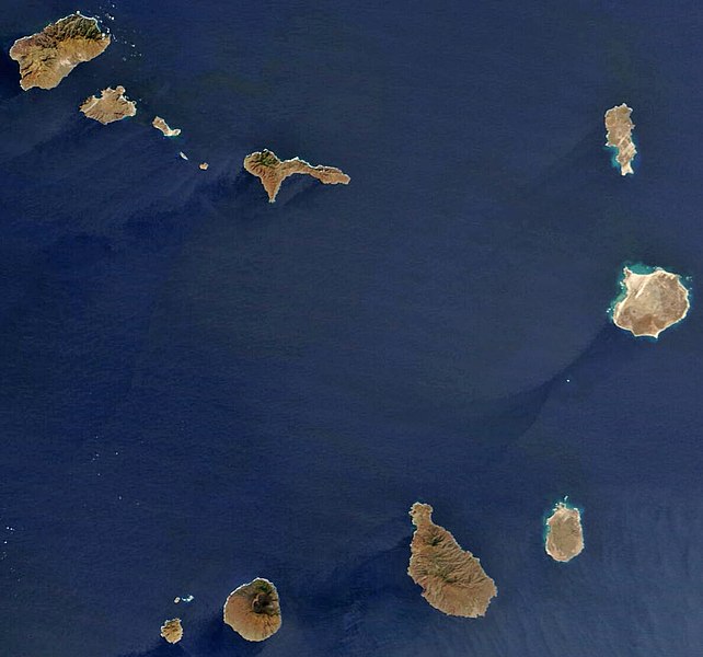
Fayil:Satellite image of Cape Verde in December 2002.jpg

Yanayin wannan rigayi gani: 642 × 600 pixels. Wasu yarjejeniyoyi: 257 × 240 pixels | 514 × 480 pixels | 822 × 768 pixels | 1,189 × 1,111 pixels.
Hoton asali (pikisal 1,189 × 1,111, girman fayil: 485 KB, irin MIME: image/jpeg)
| Bayani |
Español: Imagen satélite de las islas de Cabo Verde
English: satellite image of the Cape Verde Islands
Português: imagem de satélite das ilhas de Cabo Verde |
|||||
| Rana | ||||||
| Masomi | Cropped image, original taken from NASA's Visible Earth http://visibleearth.nasa.gov/view_rec.php?id=4638 | |||||
| Marubucin | NASA's Visible Earth | |||||
| Izini (Sake amfani da wannan fayil) |
|

Tarihin fayil
Ku latsa rana/lokaci ku ga fayil yadda yake a wannan lokaci
| Rana/Lokaci | Wadar sufa | Kusurwowi | Ma'aikaci | Bahasi | |
|---|---|---|---|---|---|
| na yanzu | 14:24, 18 Oktoba 2008 | | 1,189 × 1,111 (485 KB) | Waldyrious | Reverted to previous version (with consent of the latest version's uploader, see http://commons.wikimedia.org/w/index.php?title=User_talk:JavierMC&diff=15295109&oldid=15294283 ) |
| 01:12, 16 Oktoba 2008 |  | 1,170 × 1,094 (782 KB) | JavierMC | reduce noise using FFT-iFFT filter and adjust levels for clarity | |
| 17:48, 6 Mayu 2008 |  | 1,189 × 1,111 (485 KB) | Waldyrious | less destructive enhancement | |
| 12:25, 16 ga Afirilu, 2008 |  | 1,189 × 1,111 (140 KB) | AVM | Color-enhanced version of previous image | |
| 14:32, 26 Disamba 2004 |  | 1,189 × 1,111 (70 KB) | Hautala | {{PD-USGov-NASA}} Satellite image of Cape Verde in December 2002. Cropped image, original taken from NASA's Visible Earth http://visibleearth.nasa.gov/cgi-bin/viewrecord?23101 |
Amfani da fayil
Wadannan 2 shafuka suna amfani wannan fayil:
Amfanin fayil a ko'ina
Wadannan sauran wikis suna amfani da fayil din anan
- Amfani a kan af.wikipedia.org
- Amfani a kan ar.wikipedia.org
- Amfani a kan arz.wikipedia.org
- Amfani a kan ast.wikipedia.org
- Amfani a kan ca.wikipedia.org
- Amfani a kan ceb.wikipedia.org
- Amfani a kan dag.wikipedia.org
- Amfani a kan de.wikivoyage.org
- Amfani a kan dga.wikipedia.org
- Amfani a kan diq.wikipedia.org
- Amfani a kan el.wikipedia.org
- Amfani a kan en.wikipedia.org
- Geography of Cape Verde
- Talk:Community of Portuguese Language Countries
- Talk:Henrik Larsson
- Talk:Aristides Pereira
- Talk:Public holidays in Cape Verde
- Talk:Music of Cape Verde
- Talk:Raso lark
- Talk:African Party for the Independence of Guinea and Cape Verde
- Talk:Patrick Vieira
- Talk:Pico do Fogo
- Talk:Flag of Cape Verde
- Talk:Hurricane Alberto (2000)
- Talk:ECOWAS
- Talk:Hurricane Faith
- Talk:Hurricane Allen
- Talk:Santo Antão, Cape Verde
- Talk:Cape Verdean Americans
- Talk:Fogo, Cape Verde
- Talk:Luso-American
- Talk:1901 Atlantic hurricane season
- Talk:Battle of Porto Praya
- Talk:Cape Verdean escudo
- Talk:Lusitanic
- Talk:Effie M. Morrissey
- Talk:Espargos
- Talk:Eco (currency)
- Talk:Tropical Storm Beryl (1982)
- Talk:Portuguese Colonial War
- Talk:Cape Verde hurricane
- Talk:Cape Verdean real
- Talk:Claridade
- Talk:Associação dos Escuteiros de Cabo Verde
- Talk:.cv
Duba ƙarin amfanin wannan fayil.