
File:Achaemenid Empire 500 BC.png

Yanayin wannan rigayi gani: 800 × 427 pixels. Wasu yarjejeniyoyi: 320 × 171 pixels | 640 × 341 pixels | 1,024 × 546 pixels | 1,280 × 683 pixels | 3,070 × 1,637 pixels.
Hoton asali (pikisal 3,070 × 1,637, girman fayil: 811 KB, irin MIME: image/png)
Taƙaici
| Bayani |
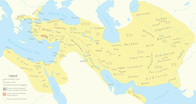
English: A map of the Achaemenid Empire around 500 BC featuring ancient regions, settlements and Satrapies. This map assembles information from the Historischer Schul-Atlas zur alten, mittleren und neueren Geschichte by Heinrich Kiepert and Carl Wolff from 1879 as accessed from GEI Digital, the 1923 edition of Historical Atlas by William R. Shepherd as accessed from the Perry-Castañeda Library's online map collection and Livius.org's article on the Satrapies of the Achaemenid Empire according to Herodotus. |
| Rana | |
| Masomi | Aikin na |
| Marubucin | Cattette |
Lasisi
I, the copyright holder of this work, hereby publish it under the following license:
This file is licensed under the Creative Commons Attribution 4.0 International license.
- Za ka iya:
- a raba – dan kwafa, yadawa da aika aikin
- dan maimaita – dan daukar aikin
- A karkashin wannan sharuddan
- Jinginarwa – Dole ku bada jinjina da ta dace, samar da linki zuwa lasisin, da kuma bayyana ko kunyi sauyi. Zaku iya haka ta yadda ta dace, amma ba kowace hanya ba wanda zai nuna mai-lasisin yana goyon bayan ku ba ko goyon bayan amfanin da kuke yi ba.
Tarihin fayil
Ku latsa rana/lokaci ku ga fayil yadda yake a wannan lokaci
| Rana/Lokaci | Wadar sufa | Kusurwowi | Ma'aikaci | Bahasi | |
|---|---|---|---|---|---|
| na yanzu | 07:01, 12 ga Maris, 2021 | | 3,070 × 1,637 (811 KB) | Cattette | Changed terminology, added Cyropolis |
| 06:05, 9 ga Maris, 2021 |  | 3,070 × 1,637 (811 KB) | Cattette | Added more cities | |
| 21:52, 8 ga Maris, 2021 |  | 3,070 × 1,637 (807 KB) | Cattette | Removed anachronistic labels, removed Thrace and Macedonia as Satrapies | |
| 20:44, 8 ga Maris, 2021 |  | 3,070 × 1,637 (813 KB) | Cattette | Fixed north eastern border, tweaked satrapies | |
| 18:55, 8 ga Maris, 2021 |  | 3,070 × 1,637 (794 KB) | Cattette | Tweaked borders and satraps | |
| 15:20, 8 ga Maris, 2021 |  | 3,070 × 1,637 (789 KB) | Cattette | Fixed Indian border again, added cities in Greece | |
| 07:02, 8 ga Maris, 2021 |  | 3,070 × 1,637 (785 KB) | Cattette | Stronger color, capitals, more cities, added Indian territories beyond the Indus | |
| 14:26, 7 ga Maris, 2021 |  | 2,923 × 1,637 (729 KB) | Cattette | Uploaded own work with UploadWizard |
Amfani da fayil
Wadannan shafi na amfani wannan fayil:
Amfanin fayil a ko'ina
Wadannan sauran wikis suna amfani da fayil din anan
- Amfani a kan arz.wikipedia.org
- Amfani a kan ast.wikipedia.org
- Amfani a kan ceb.wikipedia.org
- Amfani a kan cs.wikipedia.org
- Amfani a kan en.wikipedia.org
- Amfani a kan fa.wikipedia.org
- Amfani a kan ga.wikipedia.org
- Amfani a kan gl.wikipedia.org
- Amfani a kan he.wikipedia.org
- Amfani a kan ko.wikipedia.org
- Amfani a kan ku.wikipedia.org
- Amfani a kan pl.wikipedia.org
- Amfani a kan tg.wikipedia.org
- Amfani a kan www.wikidata.org