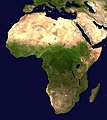
File:Africa satellite orthographic.jpg

Yanayin wannan rigayi gani: 534 × 600 pixels. Wasu yarjejeniyoyi: 214 × 240 pixels | 427 × 480 pixels | 684 × 768 pixels | 912 × 1,024 pixels | 1,624 × 1,824 pixels.
Hoton asali (pikisal 1,624 × 1,824, girman fayil: 535 KB, irin MIME: image/jpeg)
Tarihin fayil
Ku latsa rana/lokaci ku ga fayil yadda yake a wannan lokaci
| Rana/Lokaci | Wadar sufa | Kusurwowi | Ma'aikaci | Bahasi | |
|---|---|---|---|---|---|
| na yanzu | 09:44, 19 ga Afirilu, 2005 |  | 1,624 × 1,824 (535 KB) | Ghalas | A composed satellite photograph of Africa in orthographic projection This is NASA [http://visibleearth.nasa.gov/view_rec.php?vev1id=11656 "Blue Marble"] image applied as a texture on a sphere u |
Amfani da fayil
Wadannan 2 shafuka suna amfani wannan fayil:
Amfanin fayil a ko'ina
Wadannan sauran wikis suna amfani da fayil din anan
- Amfani a kan af.wikipedia.org
- Amfani a kan ang.wikipedia.org
- Amfani a kan ar.wikipedia.org
- Amfani a kan ar.wikinews.org
- Amfani a kan ary.wikipedia.org
- Amfani a kan arz.wikipedia.org
- Amfani a kan ast.wikipedia.org
- Amfani a kan as.wikipedia.org
- Amfani a kan awa.wikipedia.org
- Amfani a kan az.wikipedia.org
- Amfani a kan bat-smg.wikipedia.org
- Amfani a kan ba.wikipedia.org
- Amfani a kan be-tarask.wikipedia.org
- Amfani a kan be.wikipedia.org
- Amfani a kan bg.wikipedia.org
Duba ƙarin amfanin wannan fayil.


