
File:Air massif sat map south.png
Babu wata babbar saƙa.
Air_massif_sat_map_south.png (pikisal 338 × 426, girman fayil: 235 KB, irin MIME: image/png)
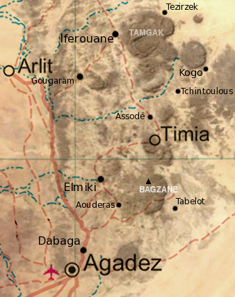
| Bayani | Map of the southern half of the Air Massif, northern Niger. Created from an overlay of PD File:Un-niger.png and PD File:Niger_BMNG.png, plus map locations derived from fallingrain.com. |
| Rana | (UTC) |
| Masomi | |
| Marubucin |
|
| This is a retouched picture, which means that it has been digitally altered from its original version. Modifications: Overlay of two images, scale, add locations, names. The original can be viewed here: Niger BMNG.png:
|
| I, the copyright holder of this work, release this work into the public domain. This applies worldwide. In some countries this may not be legally possible; if so: I grant anyone the right to use this work for any purpose, without any conditions, unless such conditions are required by law. |
Original upload log
This image is a derivative work of the following images:
- Image:Niger_BMNG.png licensed with PD-WorldWind
- 2006-04-26T18:55:04Z Hautala 2427x1919 (3901170 Bytes) {{PD-WorldWind}} Satellite image of Niger in September 2004. Screenshot from NASA World Wind, Blue Marble Next-Generation layer. [[Category:Satellite images of countries]]
Uploaded with derivativeFX
Tarihin fayil
Ku latsa rana/lokaci ku ga fayil yadda yake a wannan lokaci
| Rana/Lokaci | Wadar sufa | Kusurwowi | Ma'aikaci | Bahasi | |
|---|---|---|---|---|---|
| na yanzu | 19:31, 17 Disamba 2008 | | 338 × 426 (235 KB) | T L Miles | {{Information |Description= Map of the southern half of the Air Massif, northern Niger. Created from an overlay of PD File:Un-niger.png and PD File:Niger_BMNG.png, plus map locations derived from fallingrain.com. |Source=*Image:Niger_BMNG.png |Date= |
Amfani da fayil
Wadannan 3 shafuka suna amfani wannan fayil:
Amfanin fayil a ko'ina
Wadannan sauran wikis suna amfani da fayil din anan
- Amfani a kan ar.wikipedia.org
- Amfani a kan bg.wikipedia.org
- Amfani a kan ceb.wikipedia.org
- Amfani a kan de.wikipedia.org
- Amfani a kan el.wikipedia.org
- Amfani a kan en.wikipedia.org
- Amfani a kan eo.wikipedia.org
- Amfani a kan es.wikipedia.org
- Amfani a kan fi.wikipedia.org
- Amfani a kan fr.wikipedia.org
- Amfani a kan he.wikipedia.org
- Amfani a kan id.wikipedia.org
- Amfani a kan it.wikipedia.org
- Amfani a kan mt.wikipedia.org
- Amfani a kan no.wikipedia.org
- Amfani a kan ru.wikipedia.org
- Amfani a kan uk.wikipedia.org
- Amfani a kan www.wikidata.org
- Amfani a kan xh.wikipedia.org