
File:Alabama Capitol Building.jpg

Yanayin wannan rigayi gani: 800 × 465 pixels. Wasu yarjejeniyoyi: 320 × 186 pixels | 640 × 372 pixels | 1,024 × 595 pixels.
Hoton asali (pikisal 1,024 × 595, girman fayil: 617 KB, irin MIME: image/jpeg)
|
This is an image of a place or building that is listed on the National Register of Historic Places in the United States of America. Its reference number is 66000152. |
| Bayani |
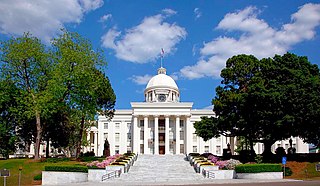
English: Capitol Building, Mongomery, Alabama. |
||||||||||||||||||||||||||
| Rana | |||||||||||||||||||||||||||
| Masomi |
|
||||||||||||||||||||||||||
| Marubucin |
|
||||||||||||||||||||||||||
| Izini (Sake amfani da wannan fayil) |
|
||||||||||||||||||||||||||


| Object location | | View this and other nearby images on: OpenStreetMap |
|---|
Tarihin fayil
Ku latsa rana/lokaci ku ga fayil yadda yake a wannan lokaci
| Rana/Lokaci | Wadar sufa | Kusurwowi | Ma'aikaci | Bahasi | |
|---|---|---|---|---|---|
| na yanzu | 15:29, 7 ga Augusta, 2011 | | 1,024 × 595 (617 KB) | Altairisfar | color balance |
| 14:10, 6 Nuwamba, 2010 |  | 1,024 × 595 (141 KB) | Altairisfar | {{Information |Description= {{en|Capitol Building, Mongomery, Alabama.}} |Source={{LOC-image|highsm.07064}} |Date=2010-04-21 |Author=Carol M. Highsmith |Permission={{PD-Highsmith}} |other_versions= }} Category:Carol M. Highsmith [[Category:2010 in Al |
Amfani da fayil
Wadannan shafi na amfani wannan fayil:
Amfanin fayil a ko'ina
Wadannan sauran wikis suna amfani da fayil din anan
- Amfani a kan an.wikipedia.org
- Amfani a kan ar.wikipedia.org
- Amfani a kan ary.wikipedia.org
- Amfani a kan arz.wikipedia.org
- Amfani a kan ast.wikipedia.org
- Amfani a kan bn.wikipedia.org
- Amfani a kan ca.wikipedia.org
- Amfani a kan cy.wikipedia.org
- Amfani a kan dag.wikipedia.org
- Amfani a kan de.wikipedia.org
- Amfani a kan de.wikivoyage.org
- Amfani a kan diq.wikipedia.org
- Amfani a kan el.wikipedia.org
- Amfani a kan en.wikipedia.org
- Alabama
- Mobile, Alabama
- Montgomery, Alabama
- Birmingham, Alabama
- Dothan, Alabama
- Fort Payne, Alabama
- Huntsville, Alabama
- Talladega, Alabama
- List of municipalities in Alabama
- List of National Historic Landmarks in Alabama
- Template:Largest cities of Alabama
- User:CosmicWillpower/sandbox
- Wikipedia:WikiProject University of Virginia/Truth and Evidence in Academic Research/Listeria/SNAC but no gender
- Portal:Alabama
- User:UCO2009bluejay/Oklahomaworkpage3
- Amfani a kan en.wikinews.org
- Amfani a kan en.wikivoyage.org
- Amfani a kan es.wikipedia.org
- Amfani a kan eu.wikipedia.org
- Amfani a kan fa.wikipedia.org
- Amfani a kan fi.wiktionary.org
- Amfani a kan fr.wikinews.org
- Amfani a kan fr.wikivoyage.org
- Amfani a kan ga.wikipedia.org
- Amfani a kan glk.wikipedia.org
- Amfani a kan gl.wikipedia.org
- Amfani a kan he.wikipedia.org
Duba ƙarin amfanin wannan fayil.