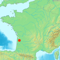
File:Bordeaux dot2.png
Bordeaux_dot2.png (pikisal 567 × 568, girman fayil: 559 KB, irin MIME: image/png)
Tarihin fayil
Ku latsa rana/lokaci ku ga fayil yadda yake a wannan lokaci
| Rana/Lokaci | Wadar sufa | Kusurwowi | Ma'aikaci | Bahasi | |
|---|---|---|---|---|---|
| na yanzu | 09:11, 22 ga Maris, 2006 |  | 567 × 568 (559 KB) | Frombenny~commonswiki | New version with indication that Corsica is not at its GPS location. |
| 13:21, 3 ga Maris, 2006 |  | 567 × 568 (558 KB) | Piero Montesacro | Reverted to earlier revision | |
| 13:08, 3 ga Maris, 2006 |  | 584 × 600 (484 KB) | Piero Montesacro | Reverted to earlier revision | |
| 21:39, 9 ga Faburairu, 2006 |  | 567 × 568 (558 KB) | Frombenny~commonswiki | Map of France includes Corsica | |
| 11:03, 24 ga Janairu, 2006 |  | 584 × 600 (484 KB) | Ludo33 | Locator map of Bordeaux, France |
Amfani da fayil
Wadannan shafi na amfani wannan fayil:
Amfanin fayil a ko'ina
Wadannan sauran wikis suna amfani da fayil din anan
- Amfani a kan arz.wikipedia.org
- Amfani a kan ast.wikipedia.org
- Amfani a kan ca.wikipedia.org
- Amfani a kan ceb.wikipedia.org
- Amfani a kan diq.wikipedia.org
- Amfani a kan eml.wikipedia.org
- Amfani a kan eu.wikipedia.org
- Amfani a kan fr.wikipedia.org
- Amfani a kan fr.wikinews.org
- Amfani a kan ga.wikipedia.org
- Amfani a kan gl.wikipedia.org
- Amfani a kan ht.wikipedia.org
- Amfani a kan kab.wikipedia.org
- Amfani a kan la.wikipedia.org
- Amfani a kan la.wiktionary.org
- Amfani a kan mt.wikipedia.org
- Amfani a kan nds.wikipedia.org
- Amfani a kan nn.wikipedia.org
- Amfani a kan oc.wikipedia.org
- Amfani a kan ro.wikipedia.org
- Amfani a kan sc.wikipedia.org
- Amfani a kan tl.wikipedia.org
- Amfani a kan tt.wikipedia.org
- Amfani a kan www.wikidata.org

