
File:Cataratas Victoria, Zambia-Zimbabue, 2018-07-27, DD 30-34 PAN.jpg

Hoton asali (pikisal 16,057 × 5,192, girman fayil: 17.41 MB, irin MIME: image/jpeg)
Taƙaici
| Warning | The original file is very high-resolution. It might not load properly or could cause your browser to freeze when opened at full size. |
|---|
| Bayani |
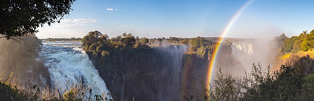
English: View of the Victoria Falls of the Zambezi River, border between Zambia (left side) and Zimbabwe (right side). The Victoria Falls is the largest sheet of falling water in the world based on its combined width of 1,708 metres (5,604 ft) and height of 108 metres (354 ft).
Español: Vista de las cataratas Victoria pertenecientes al río Zambeze, en la frontera entre Zambia (izquierda) y Zimbabue (derecha). Las cataratas Victoria son la mayor cortina de agua en caída del mundo al combinar una anchura de 1.708 m y una altura de 108 m.
Bahasa Indonesia: Tampak air terjun Victoria di Sungai Zambezi, perbatasan antara Zambia (sisi kiri) dan Zimbabwe (sisi kanan). Air terjun Victoria adalah air terjun terbesar di dunia berdasarkan gabungan lebar 1.708 meter dan tinggi 108 meter.
|
||||||||||||||||||||
| Rana | |||||||||||||||||||||
| Masomi | Aikin na | ||||||||||||||||||||
| Marubucin |
|
||||||||||||||||||||
| Other versions | |||||||||||||||||||||

.jpg)
| Camera location | | View this and other nearby images on: OpenStreetMap |
|---|
|

This image was selected as picture of the day on Wikimedia Commons for 2 January 2022. It was captioned as follows: English: View of the Victoria Falls of the Zambezi River, border between Zambia (left side) and Zimbabwe (right side). The Victoria Falls is the largest sheet of falling water in the world based on its combined width of 1,708 metres (5,604 ft) and height of 108 metres (354 ft). Other languages:
Bahasa Indonesia: Tampak air terjun Victoria di Sungai Zambezi, perbatasan antara Zambia (sisi kiri) dan Zimbabwe (sisi kanan). Air terjun Victoria adalah air terjun terbesar di dunia berdasarkan gabungan lebar 1.708 meter dan tinggi 108 meter. Čeština: Viktoriiny vodopády na řece Zambezi leží na hranici mezi státy Zambií (vlevo) a Zimbabwe (vpravo) a představují největší masu padající vody na světě s šířkou 1 800 a výškou 108 m. English: View of the Victoria Falls of the Zambezi River, border between Zambia (left side) and Zimbabwe (right side). The Victoria Falls is the largest sheet of falling water in the world based on its combined width of 1,708 metres (5,604 ft) and height of 108 metres (354 ft). Español: Vista de las cataratas Victoria pertenecientes al río Zambeze, en la frontera entre Zambia (izquierda) y Zimbabue (derecha). Las cataratas Victoria son la mayor cortina de agua en caída del mundo al combinar una anchura de 1.708 m y una altura de 108 m. Français : Les chutes Victoria sur le fleuve Zambèze constituent une frontière naturelle entre la Zambie (à gauche) et le Zimbabwe (à droite). Elles font partie des chutes les plus importantes au monde. Magyar: A Viktória-vízesés látképe a Zambézi folyón, Zambia (balra) és Zimbabwe (jobbra) határán. A Viktória-vízesés a világ legnagyobb felületű vízesése, a maga 1708 méteres szélességével és 108 méteres magasságával Nederlands: Vanaf de Victoriawatervallen vormt de Zambezi de grens tussen Zambia (links) en Zimbabwe (rechts) Português: Vista das cataratas de Vitória do rio Zambeze, na fronteira entre Zâmbia (lado esquerdo) e Zimbábue (lado direito). As cataratas de Vitória são o maior lençol de queda d'água do mundo ao combinar sua largura de 1 708 metros com a altura de 108 metros. Українська: Вид на водоспад Вікторія річки Замбезі, кордон між Замбією (ліворуч) та Зімбабве (праворуч). فارسی : نمایی از آبشار ویکتوریا واقع در رودخانه زامبزی، مرز میان زامبیا (سمت چپ) و زیمباوه (سمت راست). آبشار ویکتوریا برپایهٔ عرض 1,708 metres (5,604 ft) و ارتفاع 108 metres (354 ft) ترکیبی، بزرگترین صفحه آب در حال سقوط جهان است. |
Lasisi
Another one of my pictures: Want to see more works of mine? click here |
Under this condition:
Please, use this work legally fulfilling the terms of the license! Please, let me know if you use this work outside Wikimedia Commons sending me an email on Furthermore, if you:
please, do not hesitate to contact me. |

|
Please do not overwrite the author's version with a modified image without discussing with the author. The author would like to make corrections only from the uncompressed RAW file. This ensures that changes are preserved and are based on the best possible source to achieve a high quality. If you think that changes are required, please, get in touch with the author. Otherwise, you can upload a new image with a different name without overwriting this one. Use {{Derived from}} or {{Extracted from}} for this purpose. |
- Za ka iya:
- a raba – dan kwafa, yadawa da aika aikin
- dan maimaita – dan daukar aikin
- A karkashin wannan sharuddan
- Jinginarwa – Dole ku bada jinjina da ta dace, samar da linki zuwa lasisin, da kuma bayyana ko kunyi sauyi. Zaku iya haka ta yadda ta dace, amma ba kowace hanya ba wanda zai nuna mai-lasisin yana goyon bayan ku ba ko goyon bayan amfanin da kuke yi ba.
- Yada ahaka – Idan kuka maimaita, sabuntawa, ko kari akan wannan, dole ku bayar da gudunmuwar ku karkashin iri daya ko lasisi data dace kamar na asali.
This image has been assessed using the Quality image guidelines and is considered a Quality image.
|
Tarihin fayil
Ku latsa rana/lokaci ku ga fayil yadda yake a wannan lokaci
| Rana/Lokaci | Wadar sufa | Kusurwowi | Ma'aikaci | Bahasi | |
|---|---|---|---|---|---|
| na yanzu | 18:48, 11 ga Yuni, 2019 | 16,057 × 5,192 (17.41 MB) | Poco a poco | Slight CA, curves of the tree on top left | |
| 15:18, 10 ga Yuni, 2019 | 16,057 × 5,192 (17.45 MB) | Poco a poco | Curves | ||
| 11:01, 8 ga Yuni, 2019 | 16,057 × 5,192 (15.55 MB) | Poco a poco | Dust spots and slight CA | ||
| 19:52, 20 Oktoba 2018 | 16,057 × 5,192 (15.58 MB) | Poco a poco | User created page with UploadWizard |
Amfani da fayil
Wadannan shafi na amfani wannan fayil:
Amfanin fayil a ko'ina
Wadannan sauran wikis suna amfani da fayil din anan
- Amfani a kan af.wikipedia.org
- Amfani a kan alt.wikipedia.org
- Amfani a kan ar.wikipedia.org
- Amfani a kan ast.wikipedia.org
- Amfani a kan av.wikipedia.org
- Amfani a kan ceb.wikipedia.org
- Amfani a kan crh.wikipedia.org
- Amfani a kan cv.wikipedia.org
- Amfani a kan es.wikipedia.org
- Amfani a kan et.wikipedia.org
- Amfani a kan fa.wikipedia.org
- Amfani a kan fr.wikipedia.org
- Amfani a kan he.wikipedia.org
- Amfani a kan hu.wikipedia.org
- Amfani a kan hy.wikipedia.org
- Amfani a kan ka.wikipedia.org
- Amfani a kan ko.wikipedia.org
- Amfani a kan lbe.wikipedia.org
- Amfani a kan lb.wikipedia.org
- Amfani a kan lez.wikipedia.org
- Amfani a kan mk.wikipedia.org
- Amfani a kan os.wikipedia.org
- Amfani a kan pt.wikipedia.org
- Amfani a kan ru.wikipedia.org
- Amfani a kan rw.wikipedia.org
- Amfani a kan sah.wikipedia.org
- Amfani a kan sw.wikipedia.org
- Amfani a kan uk.wikipedia.org
- Amfani a kan vep.wikipedia.org
- Amfani a kan vi.wikipedia.org
- Amfani a kan yi.wikipedia.org
- Amfani a kan zh.wikipedia.org