
File:Invasions of the Roman Empire 1.png

Yanayin wannan rigayi gani: 800 × 566 pixels. Wasu yarjejeniyoyi: 320 × 226 pixels | 640 × 453 pixels | 1,024 × 724 pixels | 1,280 × 905 pixels | 1,954 × 1,382 pixels.
Hoton asali (pikisal 1,954 × 1,382, girman fayil: 269 KB, irin MIME: image/png)
Taƙaici
| Bayani |
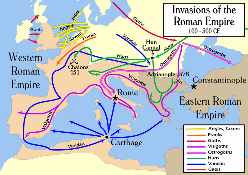
English: Map of the "barbarian" invasions by the Angles, Saxons, Jutes, Franks, Goths, Visigoths, Ostrogoths, Huns and Vandals of the Roman Empire showing the major incursions from 100 to 500 CE.
|
|||
| Rana | ||||
| Masomi | Aikin na | |||
| Marubucin | User:MapMaster | |||
| Other versions |
[]
|


Lasisi
I, the copyright holder of this work, hereby publish it under the following license:
This file is licensed under the Creative Commons Attribution-Share Alike 2.5 Generic license.
- Za ka iya:
- a raba – dan kwafa, yadawa da aika aikin
- dan maimaita – dan daukar aikin
- A karkashin wannan sharuddan
- Jinginarwa – Dole ku bada jinjina da ta dace, samar da linki zuwa lasisin, da kuma bayyana ko kunyi sauyi. Zaku iya haka ta yadda ta dace, amma ba kowace hanya ba wanda zai nuna mai-lasisin yana goyon bayan ku ba ko goyon bayan amfanin da kuke yi ba.
- Yada ahaka – Idan kuka maimaita, sabuntawa, ko kari akan wannan, dole ku bayar da gudunmuwar ku karkashin iri daya ko lasisi data dace kamar na asali.
Tarihin fayil
Ku latsa rana/lokaci ku ga fayil yadda yake a wannan lokaci
| Rana/Lokaci | Wadar sufa | Kusurwowi | Ma'aikaci | Bahasi | |
|---|---|---|---|---|---|
| na yanzu | 21:08, 14 ga Faburairu, 2022 | | 1,954 × 1,382 (269 KB) | SKIBLY101 | add the scotti |
| 03:36, 9 ga Janairu, 2022 |  | 1,954 × 1,362 (127 KB) | Jul059 | Lossless file size reduction | |
| 16:07, 26 ga Faburairu, 2014 |  | 1,954 × 1,362 (139 KB) | Capmo | cropped very minor white margin | |
| 08:35, 17 ga Yuli, 2007 |  | 1,962 × 1,374 (139 KB) | Nihad Hamzic | Removed alpha channel, what enabled me to losslessly reduce color domain to 8-bit. The result is a much, much smaller file. If alpha channel is indeed needed, then just revert the actual image to the one which I had previously uploaded (around 480 KB). | |
| 10:48, 16 ga Yuli, 2007 |  | 1,962 × 1,374 (488 KB) | Nihad Hamzic | Further reduced image size by losslessly optimising PNG compression type. This image's color domain could be reduced to 8-bit if alpha channel was removed, resulting in enormous image size reducion. Is alpha channel really needed here? | |
| 19:27, 31 Oktoba 2006 |  | 1,962 × 1,374 (624 KB) | MapMaster | Smaller, with some corrections and improvements | |
| 15:17, 21 Oktoba 2006 |  | 1,959 × 1,398 (603 KB) | MapMaster | Improved version | |
| 21:35, 19 Oktoba 2006 |  | 1,961 × 1,405 (602 KB) | MapMaster | I corrected the "Huns" route on this map, and am attempting to uploaded a 50% smaller version (Kbyte-wise). | |
| 01:35, 2 Oktoba 2006 |  | 3,948 × 2,827 (1.28 MB) | MapMaster | uploaded improved map | |
| 18:27, 1 Oktoba 2006 |  | 3,944 × 2,814 (1.04 MB) | MapMaster | Map of the "barbarian" invasions of the Roman Empire |
Amfani da fayil
Wadannan 2 shafuka suna amfani wannan fayil:
Amfanin fayil a ko'ina
Wadannan sauran wikis suna amfani da fayil din anan
- Amfani a kan ar.wikipedia.org
- Amfani a kan azb.wikipedia.org
- Amfani a kan az.wikipedia.org
- Amfani a kan ba.wikipedia.org
- Amfani a kan be-tarask.wikipedia.org
- Amfani a kan be.wikipedia.org
- Amfani a kan bg.wikipedia.org
- Amfani a kan ckb.wikipedia.org
- Amfani a kan csb.wikipedia.org
- Amfani a kan cs.wikipedia.org
- Amfani a kan da.wikipedia.org
- Amfani a kan de.wikipedia.org
- Amfani a kan de.wikibooks.org
- Amfani a kan diq.wikipedia.org
- Amfani a kan el.wikipedia.org
- Amfani a kan en.wikipedia.org
- Civilization
- Germanic peoples
- History of Europe
- Ostrogoths
- Roman Empire
- History of Austria
- History of Bulgaria
- History of Tunisia
- Ancient history
- Migration Period
- Barbarian
- Seeress (Germanic)
- Western Roman Empire
- Ancient Rome
- Early Middle Ages
- Fall of the Western Roman Empire
- Talk:Attila/Archive 2
- Chernyakhov culture
- Roman Gaul
Duba ƙarin amfanin wannan fayil.