
File:Kudat Sabah Tanjung Simpang Mengayau-23.jpg

Hoton asali (pikisal 5,351 × 3,567, girman fayil: 13.94 MB, irin MIME: image/jpeg)
Taƙaici
| Bayani |
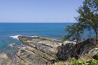
English: Kudat, Sabah: Tanjung Simpang Mengayau (Tip of Borneo) |
||||||
| Rana | |||||||
| Masomi | Aikin na | ||||||
| Marubucin | CEphoto, Uwe Aranas | ||||||
| Izini (Sake amfani da wannan fayil) |
|
||||||


| Object location | | View this and other nearby images on: OpenStreetMap |
|---|
|
|
Do not upload new revisions over this file version without my explicit consent. Instead, use the possibility to upload a new version under a new name and tag it as a derivate or extract of this file. |

Lasisi
- Za ka iya:
- a raba – dan kwafa, yadawa da aika aikin
- dan maimaita – dan daukar aikin
- A karkashin wannan sharuddan
- Jinginarwa – Dole ku bada jinjina da ta dace, samar da linki zuwa lasisin, da kuma bayyana ko kunyi sauyi. Zaku iya haka ta yadda ta dace, amma ba kowace hanya ba wanda zai nuna mai-lasisin yana goyon bayan ku ba ko goyon bayan amfanin da kuke yi ba.
- Yada ahaka – Idan kuka maimaita, sabuntawa, ko kari akan wannan, dole ku bayar da gudunmuwar ku karkashin iri daya ko lasisi data dace kamar na asali.
Tarihin fayil
ku Latsa rana/lokaci ku ga fayil yadda yake a wannan lokaci
| Rana/Lokaci | Wadar sufa | Kusurwowi | Ma'aikaci | Bahasi | |
|---|---|---|---|---|---|
| na yanzu | 21:50, 7 Nuwamba, 2014 | | 5,351 × 3,567 (13.94 MB) | Cccefalon | =={{int:filedesc}}== {{Information |description={{en|1=Kudat, Sabah: Tanjung Simpang Mengayau (Tip of Borneo)}} |date=2014-10-14 |source={{own}} |author=CEphoto, Uwe Aranas |permission={{User:Cccefalon/permission}} |other_versions= |... |
Amfani da fayil
Babu shafuka da suke amfani da fayil din nan.
Amfanin fayil a ko'ina
Wadannan sauran wikis suna amfani da fayil din anan
- Amfani a kan ceb.wikipedia.org
- Amfani a kan de.wikipedia.org
- Amfani a kan fa.wikipedia.org
- Amfani a kan fr.wikipedia.org
- Amfani a kan ko.wikipedia.org
- Amfani a kan ms.wikipedia.org
- Amfani a kan no.wikipedia.org
- Amfani a kan sv.wikipedia.org
- Amfani a kan ta.wikipedia.org
- Amfani a kan uk.wikipedia.org
- Amfani a kan ur.wikipedia.org