
File:Missouri Compromise Line.svg

Size of this PNG preview of this SVG file: 800 × 495 pixels. Wasu yarjejeniyoyi: 320 × 198 pixels | 640 × 396 pixels | 1,024 × 633 pixels | 1,280 × 791 pixels | 2,560 × 1,583 pixels | 959 × 593 pixels.
Hoton asali (Fayil kin SVG, saƙar fikisal 959 x 593, girman fayil: 80 KB)
| Bayani |
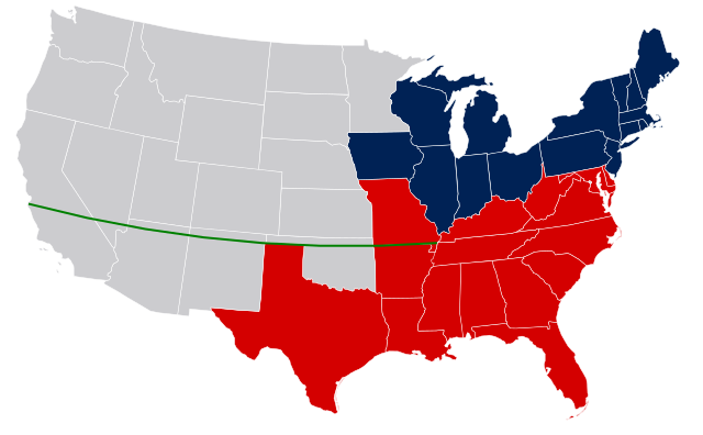
United States map with Missouri Compromise Line. Legend: Free states as of 1850 Slave states as of 1850 (not including Texas claims surrendered in Compromise of 1850) Border slave states that did not later secede in 1861 Territories (with eventual state boundaries superimposed, and including later Gadsden Purchase of 1853) Missouri Compromise Line |
| Rana | (UTC) |
| Masomi | |
| Marubucin |
| This is a retouched picture, which means that it has been digitally altered from its original version. The original can be viewed here: US Secession map 1865.svg:
|
I, the copyright holder of this work, hereby publish it under the following licenses:

|
An bada damar a kofa, a yaɗa/ko sauya wannan kundi ƙarƙashin Lasisin GNU ta kyauta, Fitarwa na 1.2 ko duk wani fitarwa da zai biyo baya daga Gidauniyar Samar da Software ta Kyauta; ba tare da sauyin sashe ba, babu Rubutun Fuskar gaban shafi, kuma babu Rubutun bayan shafi. Kofi na lasisin na nan an sanya sa aciki ƙarƙashin sashen GNU Free Documentation License. |
Wannan fayil ɗin an bada lasisin shi ƙarƙashin Creative Commons Attribution-Share Alike 3.0 Unported lasisi.
- Za ka iya:
- a raba – dan kwafa, yadawa da aika aikin
- dan maimaita – dan daukar aikin
- A karkashin wannan sharuddan
- Jinginarwa – Dole ku bada jinjina da ta dace, samar da linki zuwa lasisin, da kuma bayyana ko kunyi sauyi. Zaku iya haka ta yadda ta dace, amma ba kowace hanya ba wanda zai nuna mai-lasisin yana goyon bayan ku ba ko goyon bayan amfanin da kuke yi ba.
- Yada ahaka – Idan kuka maimaita, sabuntawa, ko kari akan wannan, dole ku bayar da gudunmuwar ku karkashin iri daya ko lasisi data dace kamar na asali.
Ku na iya zaɓan lasisin da kuke so.
Original upload log
This image is a derivitive work of the following images:
- File:US_Secession_map_1865.svg licensed with Cc-by-sa-3.0, PD-USGov-Atlas
- 2008-03-06T09:50:20Z Escondites 927x588 (238383 Bytes) {{Information |Description= |Source= |Date= |Author= |Permission= |other_versions= }}
- 2007-06-26T19:14:18Z Nostrifikator 882x553 (104504 Bytes) {{Tintazul |Description=United States map of 1865, show affiliation of states and territories regarding the Secession War (Civil War.) Legend: {{legend|#003366|Union states}} {{legend|#0197fd|Union territories}} {{legend|#EDD
- 2007-02-23T17:10:23Z Tintazul 882x553 (104420 Bytes) {{Tintazul |Description=United States map of 1865, show affiliation of states and territories regarding the Secession War (Civil War.) Legend: {{legend|#204A87|Union states}} {{legend|#729FCF|Union territories}} {{legend|#EDD
Uploaded with derivativeFX
Tarihin fayil
Ku latsa rana/lokaci ku ga fayil yadda yake a wannan lokaci
| Rana/Lokaci | Wadar sufa | Kusurwowi | Ma'aikaci | Bahasi | |
|---|---|---|---|---|---|
| na yanzu | 00:12, 17 ga Afirilu, 2011 | | 959 × 593 (80 KB) | JWB | Blank the line east of the Mississippi |
| 22:38, 16 ga Afirilu, 2011 |  | 959 × 593 (80 KB) | JWB | Remove coloring for states that did not yet exist in 1850. Reduce color difference between slave states that did or did not later stay in the Union. | |
| 19:03, 16 ga Faburairu, 2011 |  | 959 × 593 (80 KB) | Holly Cheng | oops, messed up Kansas | |
| 18:59, 16 ga Faburairu, 2011 |  | 959 × 593 (80 KB) | Holly Cheng | Image won't thumbnail anymore. Recreated using File:Blank US map.svg. | |
| 16:40, 1 Oktoba 2009 |  | 927 × 588 (233 KB) | JWB | {{Information |Description=United States secession map of 1865, plus Missouri Compromise Line. Legend: {{legend|#204A87|Union states}} {{legend|#729FCF|Union territories not permitting slavery}} {{legend|#EDD400|Border Union states, permitting slavery}} { |
Amfani da fayil
Wadannan shafi na amfani wannan fayil:
Amfanin fayil a ko'ina
Wadannan sauran wikis suna amfani da fayil din anan
- Amfani a kan ar.wikipedia.org
- Amfani a kan ca.wikipedia.org
- Amfani a kan en.wikipedia.org
- Amfani a kan en.wikibooks.org
- Amfani a kan en.wikiversity.org
- Amfani a kan eo.wikipedia.org
- Amfani a kan fr.wikipedia.org
- Amfani a kan hu.wikipedia.org
- Amfani a kan it.wikipedia.org
- Amfani a kan ja.wikipedia.org
- Amfani a kan ko.wikipedia.org
- Amfani a kan ms.wikipedia.org
- Amfani a kan no.wikipedia.org
- Amfani a kan oc.wikipedia.org
- Amfani a kan pt.wikipedia.org
- Amfani a kan simple.wikipedia.org
- Amfani a kan sv.wikipedia.org
- Amfani a kan th.wikipedia.org
- Amfani a kan zh.wikipedia.org