
File:Nyiragongo and Nyamuragira - PIA03337.png
Babu wata babbar saƙa.
Nyiragongo_and_Nyamuragira_-_PIA03337.png (pikisal 670 × 311, girman fayil: 224 KB, irin MIME: image/png)
Taƙaici
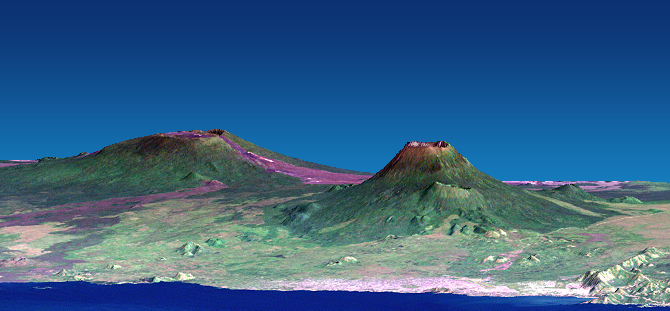
| Bayani | Depiction of the Nyiragongo and Nyamuragira volcanoes, based on data from the Shuttle Radar Topography Mission and Landsat. Vertical scale exaggerated (1.5x). |
| Rana | February 2000 - December 2001 |
| Masomi | [1] (converted to PNG). Further information: [2]. Photo ID: PIA03337 |
| Marubucin | NASA/JPL/NIMA |
| Other versions | Image:Nyiragongo and Nyamuragira - PIA03337.jpg |
This image or video was catalogued by Jet Propulsion Laboratory of the United States National Aeronautics and Space Administration (NASA) under Photo ID: PIA03337. This tag does not indicate the copyright status of the attached work. A normal copyright tag is still required. See Commons:Licensing. Other languages:
|
Lasisi
| This file is in the public domain in the United States because it was solely created by NASA. NASA copyright policy states that "NASA material is not protected by copyright unless noted". (See Template:PD-USGov, NASA copyright policy page or JPL Image Use Policy.) | ||
 |
Warnings:
|
Tarihin fayil
Ku latsa rana/lokaci ku ga fayil yadda yake a wannan lokaci
| Rana/Lokaci | Wadar sufa | Kusurwowi | Ma'aikaci | Bahasi | |
|---|---|---|---|---|---|
| na yanzu | 09:48, 20 Disamba 2007 | | 670 × 311 (224 KB) | Avenue | {{Information |Description=Depiction of the Nyiragongo and Nyamuragira volcanoes, based on data from the Shuttle Radar Topography Mission and Landsat. |Source=[http://photojournal.jpl.nasa.gov/jpeg/PIA03337.tif] (converted to PNG). Further information: [h |
Amfani da fayil
Wadannan shafi na amfani wannan fayil:
Amfanin fayil a ko'ina
Wadannan sauran wikis suna amfani da fayil din anan
- Amfani a kan de.wikipedia.org
- Amfani a kan en.wikipedia.org
- Amfani a kan es.wikipedia.org
- Amfani a kan fa.wikipedia.org
- Amfani a kan fr.wikipedia.org
- Amfani a kan fr.wikinews.org
- Amfani a kan hy.wikipedia.org
- Amfani a kan lt.wikipedia.org
- Amfani a kan ro.wikipedia.org
- Amfani a kan rw.wikipedia.org
- Amfani a kan simple.wikipedia.org
- Amfani a kan sk.wikipedia.org