
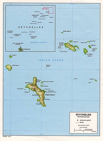
File:Seychelles large map.jpg

Yanayin wannan rigayi gani: 439 × 599 pixels. Wasu yarjejeniyoyi: 176 × 240 pixels | 352 × 480 pixels | 563 × 768 pixels | 1,102 × 1,504 pixels.
Hoton asali (pikisal 1,102 × 1,504, girman fayil: 186 KB, irin MIME: image/jpeg)

|
This map has been uploaded by Electionworld from en.wikipedia.org to enable the |
CIA public domain
| This image is a work of a Central Intelligence Agency employee, taken or made as part of that person's official duties. As a Work of the United States Government, this image or media is in the public domain in the United States.
|

|
Tarihin fayil
Ku latsa rana/lokaci ku ga fayil yadda yake a wannan lokaci
| Rana/Lokaci | Wadar sufa | Kusurwowi | Ma'aikaci | Bahasi | |
|---|---|---|---|---|---|
| na yanzu | 12:51, 29 Nuwamba, 2006 | | 1,102 × 1,504 (186 KB) | Electionworld | {{ew|en|SDC}} CIA public domain {{PD-USGov-CIA}} |
Amfani da fayil
Wadannan 2 shafuka suna amfani wannan fayil:
Amfanin fayil a ko'ina
Wadannan sauran wikis suna amfani da fayil din anan
- Amfani a kan af.wikipedia.org
- Amfani a kan ar.wikipedia.org
- Amfani a kan arz.wikipedia.org
- Amfani a kan ast.wikipedia.org
- Amfani a kan az.wikipedia.org
- Amfani a kan ba.wikipedia.org
- Amfani a kan bn.wikipedia.org
- Amfani a kan bs.wikipedia.org
- Amfani a kan ca.wikipedia.org
- Amfani a kan ceb.wikipedia.org
- Amfani a kan ckb.wikipedia.org
- Amfani a kan cs.wikipedia.org
- Amfani a kan de.wikipedia.org
- Amfani a kan el.wikipedia.org
- Amfani a kan en.wikipedia.org
Duba ƙarin amfanin wannan fayil.