
File:The Mali Empire.jpg

Hoton asali (pikisal 3,000 × 2,250, girman fayil: 3.07 MB, irin MIME: image/jpeg)


Taƙaici
| Bayani |
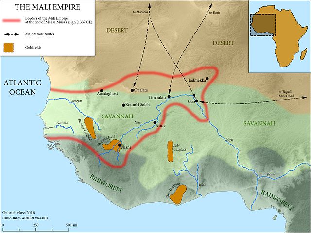
English: The Medieval Mali Empire at the end of Mansa Musa's reign (1337 CE)
Map Sources: Physical elevation representation comes from public-domain SRTM data. Coastlines follow the Barrington Atlas of the Ancient World (Princeton University Press, 2000)--while Mali hardly falls within the time period covered by this atlas, these coastlines omit major harbor construction in the modern period, and are accurate at the scale of the map. Rivers adapted from ESRI user contributions, or traced from satellite imagery. Ecological zones based on "A New Map of Standardized Terrestrial Ecosystems of Africa" (Association of American Geographers, 2013). Historical data drawn from Robert Collins and James Burns, "A History of Sub-Saharan Africa" (Cambridge University Press, 2007) (see esp. p. 86). Adapted and expanded based on lecture materials from Dr. Lisa Lindsay at the University of North Carolina-Chapel Hill, and from this map by wikimedia user Aa77zz: https://commons.wikimedia.org/wiki/File:Trans-Saharan_routes_early.svg |
| Rana | |
| Masomi | Aikin na |
| Marubucin | Gabriel Moss |
Lasisi
- Za ka iya:
- a raba – dan kwafa, yadawa da aika aikin
- dan maimaita – dan daukar aikin
- A karkashin wannan sharuddan
- Jinginarwa – Dole ku bada jinjina da ta dace, samar da linki zuwa lasisin, da kuma bayyana ko kunyi sauyi. Zaku iya haka ta yadda ta dace, amma ba kowace hanya ba wanda zai nuna mai-lasisin yana goyon bayan ku ba ko goyon bayan amfanin da kuke yi ba.
- Yada ahaka – Idan kuka maimaita, sabuntawa, ko kari akan wannan, dole ku bayar da gudunmuwar ku karkashin iri daya ko lasisi data dace kamar na asali.
Tarihin fayil
Ku latsa rana/lokaci ku ga fayil yadda yake a wannan lokaci
| Rana/Lokaci | Wadar sufa | Kusurwowi | Ma'aikaci | Bahasi | |
|---|---|---|---|---|---|
| na yanzu | 20:14, 13 ga Yuni, 2016 | | 3,000 × 2,250 (3.07 MB) | Mossmaps | User created page with UploadWizard |
Amfani da fayil
Wadannan 3 shafuka suna amfani wannan fayil:
Amfanin fayil a ko'ina
Wadannan sauran wikis suna amfani da fayil din anan
- Amfani a kan ar.wikipedia.org
- Amfani a kan arz.wikipedia.org
- Amfani a kan azb.wikipedia.org
- Amfani a kan az.wikipedia.org
- Amfani a kan ba.wikipedia.org
- Amfani a kan bg.wikipedia.org
- Amfani a kan br.wikipedia.org
- Amfani a kan en.wikipedia.org
- Amfani a kan fi.wikipedia.org
- Amfani a kan fr.wikipedia.org
- Amfani a kan gl.wikipedia.org
- Amfani a kan gpe.wikipedia.org
- Amfani a kan he.wikipedia.org
- Amfani a kan hi.wikipedia.org
- Amfani a kan hy.wikipedia.org
- Amfani a kan hyw.wikipedia.org
- Amfani a kan it.wikipedia.org
- Amfani a kan ja.wikipedia.org
- Amfani a kan ky.wikipedia.org
- Amfani a kan la.wikipedia.org
- Amfani a kan lfn.wikipedia.org
- Amfani a kan pt.wikipedia.org
- Amfani a kan ru.wikipedia.org
- Amfani a kan rw.wikipedia.org
- Amfani a kan simple.wikipedia.org
- Amfani a kan sl.wikipedia.org
- Amfani a kan te.wikipedia.org
- Amfani a kan tr.wikipedia.org
- Amfani a kan uk.wikipedia.org
- Amfani a kan vi.wikipedia.org
- Amfani a kan www.wikidata.org