
File:Uganda Topography.png

Yanayin wannan rigayi gani: 616 × 600 pixels. Wasu yarjejeniyoyi: 247 × 240 pixels | 493 × 480 pixels | 971 × 945 pixels.
Hoton asali (pikisal 971 × 945, girman fayil: 1.27 MB, irin MIME: image/png)
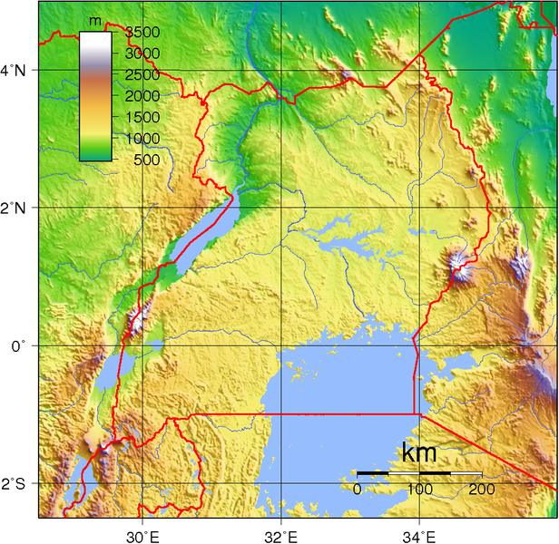
Taƙaici
| Bayani | Topographic map of Uganda. Created with GMT from SRTM data. |
| Rana | |
| Masomi | Aikin na |
| Marubucin | Sadalmelik |
Lasisi
| This work has been released into the public domain by its author, I, Sadalmelik. This applies worldwide. In some countries this may not be legally possible; if so: I, Sadalmelik grants anyone the right to use this work for any purpose, without any conditions, unless such conditions are required by law. |
Tarihin fayil
ku Latsa rana/lokaci ku ga fayil yadda yake a wannan lokaci
| Rana/Lokaci | Wadar sufa | Kusurwowi | Ma'aikaci | Bahasi | |
|---|---|---|---|---|---|
| na yanzu | 21:20, 29 ga Yuni, 2007 | | 971 × 945 (1.27 MB) | Sadalmelik | {{Information |Description=Topographic map of Uganda. Created with GMT from SRTM data. |Source=self-made |Date=June 2, 2007 |Author= Sadalmelik }} Category:Maps of Uganda Category:Topographic maps of Africa |
Amfani da fayil
Wadannan shafi na amfani wannan fayil:
Amfanin fayil a ko'ina
Wadannan sauran wikis suna amfani da fayil din anan
- Amfani a kan avk.wikipedia.org
- Amfani a kan bg.wikipedia.org
- Amfani a kan bn.wikipedia.org
- Amfani a kan da.wikipedia.org
- Amfani a kan de.wikipedia.org
- Amfani a kan el.wikipedia.org
- Amfani a kan en.wikipedia.org
- Amfani a kan es.wikipedia.org
- Amfani a kan fa.wikipedia.org
- Amfani a kan fr.wikipedia.org
- Amfani a kan he.wikipedia.org
- Amfani a kan hu.wikipedia.org
- Amfani a kan io.wikipedia.org
- Amfani a kan ka.wikipedia.org
- Amfani a kan lt.wikipedia.org
- Amfani a kan mdf.wikipedia.org
- Amfani a kan mg.wikipedia.org
- Amfani a kan mt.wikipedia.org
- Amfani a kan ru.wikipedia.org
- Amfani a kan sk.wikipedia.org
- Amfani a kan sr.wikipedia.org
- Amfani a kan uk.wikipedia.org
- Amfani a kan vep.wikipedia.org