
File:Aerial view of the Central Intelligence Agency headquarters, Langley, Virginia - Corrected and Cropped.jpg
Yanayin wannan rigayi gani: 800 × 356 pixels. Wasu yarjejeniyoyi: 320 × 142 pixels | 640 × 284 pixels | 1,024 × 455 pixels | 1,280 × 569 pixels | 2,560 × 1,138 pixels | 5,523 × 2,455 pixels.
Hoton asali (pikisal 5,523 × 2,455, girman fayil: 7.57 MB, irin MIME: image/jpeg)
Taƙaici
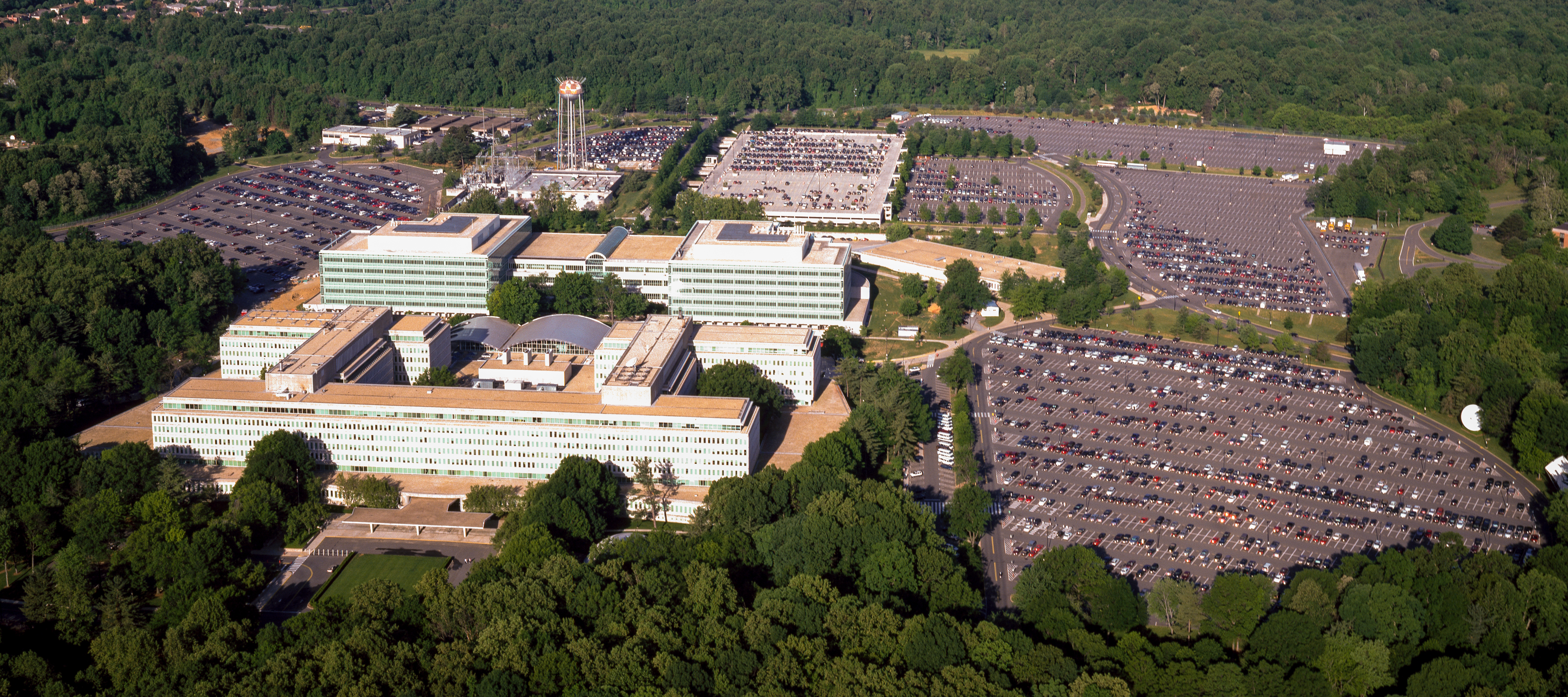
| Aerial view of the Central Intelligence Agency headquarters, Langley, Virginia
( |
|||||||||||||||||||||||||||
|---|---|---|---|---|---|---|---|---|---|---|---|---|---|---|---|---|---|---|---|---|---|---|---|---|---|---|---|
| Marubucin |
|
||||||||||||||||||||||||||
| Title |
Aerial view of the Central Intelligence Agency headquarters, Langley, Virginia |
||||||||||||||||||||||||||
| Depicted place | Central Intelligence Agency headquarters | ||||||||||||||||||||||||||
| Rana | 1980 - 2006 | ||||||||||||||||||||||||||
| Medium | 1 transparency : color | ||||||||||||||||||||||||||
| Dimensions | 4 x 5 in. or smaller. | ||||||||||||||||||||||||||
| Collection |
|
||||||||||||||||||||||||||
| Current location |
Prints and Photographs Division http://hdl.loc.gov/loc.pnp/pp.print |
||||||||||||||||||||||||||
| Notes |
|
||||||||||||||||||||||||||
| Masomi |
|
||||||||||||||||||||||||||
| Izini (Sake amfani da wannan fayil) |
Rights Advisory: No known restrictions on publication. | ||||||||||||||||||||||||||
| Other versions |
|
||||||||||||||||||||||||||


| | View this and other nearby images on: OpenStreetMap |
Lasisi
| This work is from the Carol M. Highsmith Archive collection at the Library of Congress. According to the library, there are no known copyright restrictions on the use of this work. Carol M. Highsmith has stipulated that her photographs are in the public domain. Photographs of sculpture or other works of art may be restricted by the copyright of the artist. |
 |
Tarihin fayil
Ku latsa rana/lokaci ku ga fayil yadda yake a wannan lokaci
| Rana/Lokaci | Wadar sufa | Kusurwowi | Ma'aikaci | Bahasi | |
|---|---|---|---|---|---|
| na yanzu | 16:17, 22 ga Afirilu, 2017 | | 5,523 × 2,455 (7.57 MB) | Falcorian | User created page with UploadWizard |
Amfani da fayil
Wadannan shafi na amfani wannan fayil:
Amfanin fayil a ko'ina
Wadannan sauran wikis suna amfani da fayil din anan
- Amfani a kan ar.wikipedia.org
- Amfani a kan arz.wikipedia.org
- Amfani a kan ast.wikipedia.org
- Amfani a kan azb.wikipedia.org
- Amfani a kan az.wikipedia.org
- Amfani a kan br.wikipedia.org
- Amfani a kan ca.wikipedia.org
- Amfani a kan ce.wikipedia.org
- Amfani a kan cs.wikipedia.org
- Amfani a kan cy.wikipedia.org
- Amfani a kan da.wikipedia.org
- Amfani a kan de.wikipedia.org
- Amfani a kan en.wikipedia.org
- Amfani a kan eo.wikipedia.org
- Amfani a kan eo.wikiquote.org
- Amfani a kan es.wikipedia.org
- Amfani a kan fi.wikipedia.org
- Amfani a kan fr.wikipedia.org
- Amfani a kan fr.wikinews.org
- Amfani a kan ga.wikipedia.org
- Amfani a kan he.wikipedia.org
- Amfani a kan hu.wikipedia.org
- Amfani a kan id.wikipedia.org
- Amfani a kan it.wikipedia.org
- Amfani a kan ja.wikipedia.org
- Amfani a kan ko.wikipedia.org
- Amfani a kan ky.wikipedia.org
- Amfani a kan lt.wikipedia.org
- Amfani a kan lv.wikipedia.org
- Amfani a kan mn.wikipedia.org
- Amfani a kan ne.wikipedia.org
- Amfani a kan nn.wikipedia.org
- Amfani a kan no.wikipedia.org
- Amfani a kan ro.wikipedia.org
- Amfani a kan ru.wikipedia.org
- Amfani a kan ru.wikinews.org
- Amfani a kan sk.wikipedia.org
Duba ƙarin amfanin wannan fayil.