
File:Africa-countries-WAFU-UFOA.png
Babu wata babbar saƙa.
Africa-countries-WAFU-UFOA.png (pikisal 360 × 392, girman fayil: 14 KB, irin MIME: image/png)
Taƙaici

|
This locator map image could be re-created using vector graphics as an SVG file. This has several advantages; see Commons:Media for cleanup for more information. If an SVG form of this image is available, please upload it and afterwards replace this template with
{{vector version available|new image name}}.
It is recommended to name the SVG file “Africa-countries-WAFU-UFOA.svg”—then the template Vector version available (or Vva) does not need the new image name parameter. |
| Bayani |
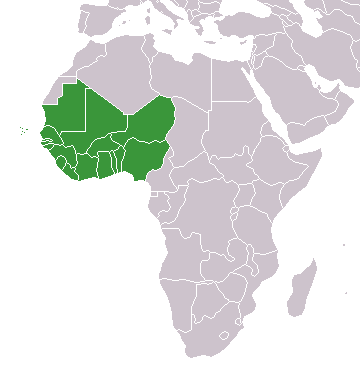
Deutsch: Karte Mitgliedstaaten der West African Football Union |
| Rana | 2 Oktoba 2004-26 |
| Masomi | Aikin na |
| Marubucin | Chtrede |
Lasisi
| I, the copyright holder of this work, release this work into the public domain. This applies worldwide. In some countries this may not be legally possible; if so: I grant anyone the right to use this work for any purpose, without any conditions, unless such conditions are required by law. |
Original upload log
The original description page was here. All following user names refer to de.wikipedia.
- 2010-04-26 07:07 Chtrede 360×392× (9916 bytes) == Beschreibung, Quelle == {{Information |Beschreibung = Karte Mitgliedstaaten der [[West African Football Union]] |Quelle = Eigenarbeit |Urheber = [[:Benutzer:Chtrede]] |Datum = 26. April 2010 |Genehmigung = |Andere Versionen = |Anmerkungen = }} == Li
Tarihin fayil
Ku latsa rana/lokaci ku ga fayil yadda yake a wannan lokaci
| Rana/Lokaci | Wadar sufa | Kusurwowi | Ma'aikaci | Bahasi | |
|---|---|---|---|---|---|
| na yanzu | 16:53, 27 ga Maris, 2016 | | 360 × 392 (14 KB) | Christian Ferrer | Reverted to version as of 08:56, 26 March 2016 (UTC) |
| 15:36, 27 ga Maris, 2016 |  | 360 × 392 (12 KB) | Insidema | Reverted to version as of 16:33, 25 March 2016 (UTC) | |
| 08:56, 26 ga Maris, 2016 |  | 360 × 392 (14 KB) | Ankry | Reverted to version as of 18:48, 9 July 2011 (UTC) | |
| 16:33, 25 ga Maris, 2016 |  | 360 × 392 (12 KB) | Hpyounes | update | |
| 18:48, 9 ga Yuli, 2011 |  | 360 × 392 (14 KB) | Maphobbyist | South Sudan has become independent on July 9, 2011. Sudan and South Sudan are shown with the new international border between them. | |
| 01:28, 4 ga Yuli, 2011 |  | 360 × 392 (10 KB) | File Upload Bot (Magnus Manske) | {{BotMoveToCommons|de.wikipedia|year={{subst:CURRENTYEAR}}|month={{subst:CURRENTMONTHNAME}}|day={{subst:CURRENTDAY}}}} {{Information |Description={{de|Karte Mitgliedstaaten der de:West African Football Union}} |Source=Transferred from [http://de.wi |
Amfani da fayil
Wadannan shafi na amfani wannan fayil:
Amfanin fayil a ko'ina
Wadannan sauran wikis suna amfani da fayil din anan
- Amfani a kan azb.wikipedia.org
- Amfani a kan br.wikipedia.org
- Amfani a kan ca.wikipedia.org
- Amfani a kan de.wikipedia.org
- Amfani a kan en.wikipedia.org
- Amfani a kan es.wikipedia.org
- Amfani a kan fi.wikipedia.org
- Amfani a kan hi.wikipedia.org
- Amfani a kan hu.wikipedia.org
- Amfani a kan incubator.wikimedia.org
- Amfani a kan kcg.wikipedia.org
- Amfani a kan mdf.wikipedia.org
- Amfani a kan no.wikipedia.org
- Amfani a kan pt.wikipedia.org
- Amfani a kan sd.wikipedia.org
- Amfani a kan smn.wikipedia.org
- Amfani a kan sn.wikipedia.org
- Amfani a kan th.wikipedia.org
- Amfani a kan uk.wikipedia.org
- Amfani a kan www.wikidata.org