
File:Amurrivermap.png

Yanayin wannan rigayi gani: 761 × 599 pixels. Wasu yarjejeniyoyi: 305 × 240 pixels | 610 × 480 pixels | 989 × 779 pixels.
Hoton asali (pikisal 989 × 779, girman fayil: 298 KB, irin MIME: image/png)
| Bayani |
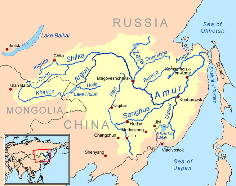
English: This is a map of the Amur River drainage basin. Русский: Карта бассейна реки Амур. |
| Rana | |
| Masomi | Own work using Digital Chart of the World and GTOPO data. |
| Marubucin | Kmusser |
| Other versions |
Derivative works of this file: Amurriversourcesmap.jpg File:Amur watershed.png |
I, the copyright holder of this work, hereby publish it under the following license:
Wannan fayil ɗin an bada lasisin shi ƙarƙashin Creative Commons Attribution-Share Alike 3.0 Unported lasisi.
- Za ka iya:
- a raba – dan kwafa, yadawa da aika aikin
- dan maimaita – dan daukar aikin
- A karkashin wannan sharuddan
- Jinginarwa – Dole ku bada jinjina da ta dace, samar da linki zuwa lasisin, da kuma bayyana ko kunyi sauyi. Zaku iya haka ta yadda ta dace, amma ba kowace hanya ba wanda zai nuna mai-lasisin yana goyon bayan ku ba ko goyon bayan amfanin da kuke yi ba.
- Yada ahaka – Idan kuka maimaita, sabuntawa, ko kari akan wannan, dole ku bayar da gudunmuwar ku karkashin iri daya ko lasisi data dace kamar na asali.

|
This map image could be re-created using vector graphics as an SVG file. This has several advantages; see Commons:Media for cleanup for more information. If an SVG form of this image is available, please upload it and afterwards replace this template with
{{vector version available|new image name}}.
It is recommended to name the SVG file “Amurrivermap.svg”—then the template Vector version available (or Vva) does not need the new image name parameter. |
Tarihin fayil
Ku latsa rana/lokaci ku ga fayil yadda yake a wannan lokaci
| Rana/Lokaci | Wadar sufa | Kusurwowi | Ma'aikaci | Bahasi | |
|---|---|---|---|---|---|
| na yanzu | 01:15, 7 ga Yuni, 2010 | | 989 × 779 (298 KB) | Ras67 | cropped |
| 20:05, 2 ga Maris, 2009 |  | 1,000 × 795 (367 KB) | Kmusser | {{Information |Description=This is a map of the Amur River drainage basin. |Source=Own work using [http://www.maproom.psu.edu/dcw/ Digital Chart of the World] and [http://edc.usgs.gov/products/elevation/gtopo30/gtopo30.html GTOPO] data. |
Amfani da fayil
Wadannan shafi na amfani wannan fayil:
Amfanin fayil a ko'ina
Wadannan sauran wikis suna amfani da fayil din anan
- Amfani a kan af.wikipedia.org
- Amfani a kan als.wikipedia.org
- Amfani a kan ar.wikipedia.org
- Amfani a kan arz.wikipedia.org
- Amfani a kan ast.wikipedia.org
- Amfani a kan azb.wikipedia.org
- Amfani a kan be-tarask.wikipedia.org
- Amfani a kan bg.wikipedia.org
- Amfani a kan bh.wikipedia.org
- Amfani a kan bn.wikipedia.org
- Amfani a kan br.wikipedia.org
- Amfani a kan bs.wikipedia.org
- Amfani a kan ca.wikipedia.org
- Amfani a kan cy.wikipedia.org
- Amfani a kan da.wikipedia.org
- Amfani a kan de.wikipedia.org
- Amfani a kan en.wikipedia.org
- Amfani a kan eo.wikipedia.org
- Amfani a kan es.wikipedia.org
Duba ƙarin amfanin wannan fayil.