
File:Baro river Gambela.jpg

Babu wata babbar saƙa.
Baro_river_Gambela.jpg (pikisal 500 × 500, girman fayil: 61 KB, irin MIME: image/jpeg)
Taƙaici
| Bayani |
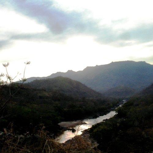
Baro River in Gambella region, Ethiopia. Original description by uploader: "taking pictures of bridges is strictly forbidden" [][?] Baro River flows to Sudan (cf. this picture). It is also the heart of the Gambella region and Gambella city. People use to go to the river to wash, refresh, chat or just take some time. People belong to many different groups: indigenous Nuer, Anuak, Majangir... or settled Highlanders (for the Abyssinian highlands regardless Amhara, Tigray or Oromo) or Sudanese refugees. The situation of demographic, ethnic and cultural diversity leads to situations of complexity. Inducing tensions, conflicts or violences. At least it is what is written in the books... So far, it looks like a paradise. |
| Rana | |
| Masomi | [1] |
| Marubucin | T U R K A I R O |
| Camera location | | View this and other nearby images on: OpenStreetMap |
|---|
Lasisi
This file is licensed under the Creative Commons Attribution 2.0 Generic license.
- Za ka iya:
- a raba – dan kwafa, yadawa da aika aikin
- dan maimaita – dan daukar aikin
- A karkashin wannan sharuddan
- Jinginarwa – Dole ku bada jinjina da ta dace, samar da linki zuwa lasisin, da kuma bayyana ko kunyi sauyi. Zaku iya haka ta yadda ta dace, amma ba kowace hanya ba wanda zai nuna mai-lasisin yana goyon bayan ku ba ko goyon bayan amfanin da kuke yi ba.
| This image was originally posted to Flickr by T U R K A I R O at https://www.flickr.com/photos/7838055@N05/2459587146. It was reviewed on 26 Afirilu 2009 by FlickreviewR and was confirmed to be licensed under the terms of the cc-by-2.0. |
Tarihin fayil
Ku latsa rana/lokaci ku ga fayil yadda yake a wannan lokaci
| Rana/Lokaci | Wadar sufa | Kusurwowi | Ma'aikaci | Bahasi | |
|---|---|---|---|---|---|
| na yanzu | 12:16, 26 ga Afirilu, 2009 | | 500 × 500 (61 KB) | Béka~commonswiki | {{Information |Description=Baro River in Gambella region, Ethiopia. Original description by uploader: [http://loc.alize.us/#/flickr:2459587146 "taking pictures of bridges is strictly forbidden"] [][?] [http://bighugelabs.com/flickr/onblack.php?id=245958 |
Amfani da fayil
Wadannan shafi na amfani wannan fayil:
Amfanin fayil a ko'ina
Wadannan sauran wikis suna amfani da fayil din anan
- Amfani a kan af.wikipedia.org
- Amfani a kan ar.wikipedia.org
- Amfani a kan arz.wikipedia.org
- Amfani a kan br.wikipedia.org
- Amfani a kan ca.wikipedia.org
- Amfani a kan ceb.wikipedia.org
- Amfani a kan cs.wikipedia.org
- Amfani a kan da.wikipedia.org
- Amfani a kan de.wikipedia.org
- Amfani a kan de.wikivoyage.org
- Amfani a kan el.wikipedia.org
- Amfani a kan en.wikipedia.org
- Amfani a kan en.wikivoyage.org
- Amfani a kan eo.wikipedia.org
- Amfani a kan es.wikipedia.org
- Amfani a kan fa.wikipedia.org
- Amfani a kan fi.wikipedia.org
- Amfani a kan fr.wikipedia.org
- Amfani a kan fr.wikivoyage.org
- Amfani a kan gl.wikipedia.org
- Amfani a kan he.wikipedia.org
- Amfani a kan hi.wikipedia.org
- Amfani a kan hr.wikipedia.org
- Amfani a kan ig.wikipedia.org
- Amfani a kan it.wikipedia.org
- Amfani a kan it.wikivoyage.org
- Amfani a kan ja.wikipedia.org
- Amfani a kan ka.wikipedia.org
- Amfani a kan ko.wikipedia.org
- Amfani a kan mt.wikipedia.org
- Amfani a kan no.wikipedia.org
Duba ƙarin amfanin wannan fayil.