
File:Buyids 970.png

Yanayin wannan rigayi gani: 800 × 509 pixels. Wasu yarjejeniyoyi: 320 × 204 pixels | 640 × 407 pixels | 1,024 × 652 pixels | 1,321 × 841 pixels.
Hoton asali (pikisal 1,321 × 841, girman fayil: 1.01 MB, irin MIME: image/png)
Taƙaici
| Bayani |
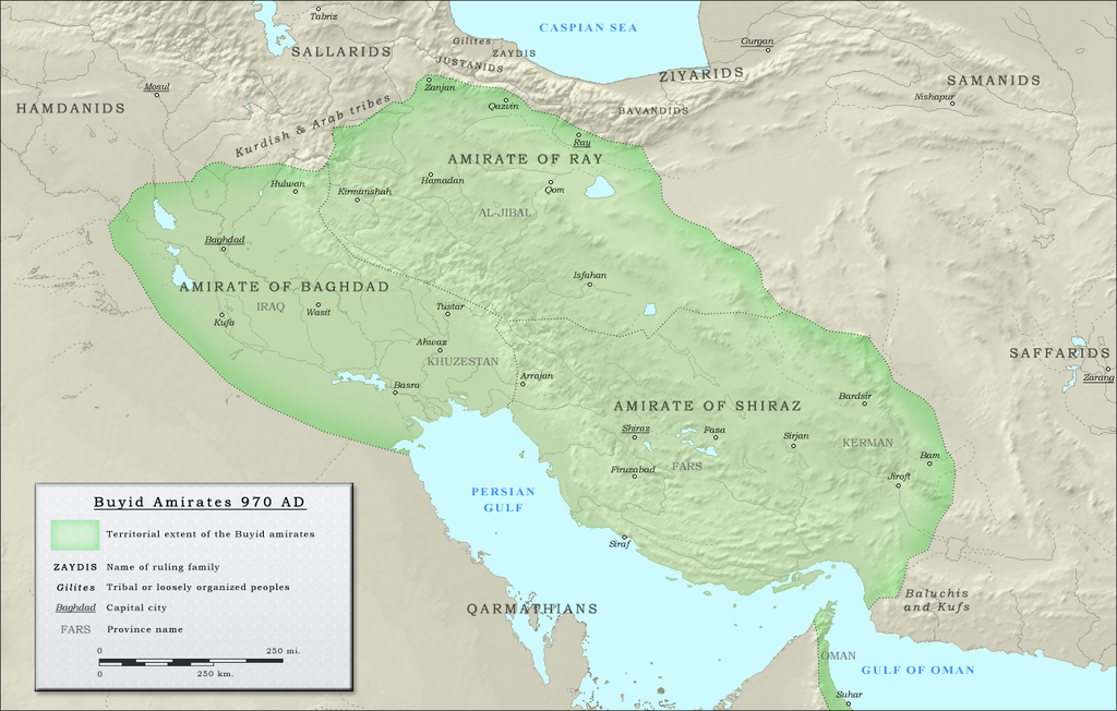
English: Map of the three emirates under control of the Buyid dynasty ca. 970 CE |
| Rana | |
| Masomi |
(Original text : Own work. Data sources :
|
| Marubucin | ro4444 |
| Izini (Sake amfani da wannan fayil) |
. Original uploader was Ro4444 at en.wikipedia CC-BY-SA-3.0; Released under the GNU Free Documentation License; Released into the public domain (by the author). |
| Other versions | العربيَّة |
Lasisi
| This work has been released into the public domain by its author, Ro4444 at Turanci Wikipedia. This applies worldwide. In some countries this may not be legally possible; if so: Ro4444 grants anyone the right to use this work for any purpose, without any conditions, unless such conditions are required by law. |
Ro4444 at Turanci Wikipedia, the copyright holder of this work, hereby publishes it under the following licenses:
Wannan fayil ɗin an bada lasisin shi ƙarƙashin Creative Commons Attribution-Share Alike 3.0 Unported lasisi.
Jinginarwa: Ro4444 at Turanci Wikipedia
- Za ka iya:
- a raba – dan kwafa, yadawa da aika aikin
- dan maimaita – dan daukar aikin
- A karkashin wannan sharuddan
- Jinginarwa – Dole ku bada jinjina da ta dace, samar da linki zuwa lasisin, da kuma bayyana ko kunyi sauyi. Zaku iya haka ta yadda ta dace, amma ba kowace hanya ba wanda zai nuna mai-lasisin yana goyon bayan ku ba ko goyon bayan amfanin da kuke yi ba.
- Yada ahaka – Idan kuka maimaita, sabuntawa, ko kari akan wannan, dole ku bayar da gudunmuwar ku karkashin iri daya ko lasisi data dace kamar na asali.

|
An bada damar a kofa, a yaɗa/ko sauya wannan kundi ƙarƙashin Lasisin GNU ta kyauta, Fitarwa na 1.2 ko duk wani fitarwa da zai biyo baya daga Gidauniyar Samar da Software ta Kyauta; ba tare da sauyin sashe ba, babu Rubutun Fuskar gaban shafi, kuma babu Rubutun bayan shafi. Kofi na lasisin na nan an sanya sa aciki ƙarƙashin sashen GNU Free Documentation License. |
Ku na iya zaɓan lasisin da kuke so.
Original upload log
The original description page was here. All following user names refer to en.wikipedia.
- 2010-09-27 05:16 Ro4444 1321×841× (1059156 bytes) == Summary == == Description == {{Information |Description= {{en| Political map in English of the Buyids in 970 A.D.}} |Source=Own work. {{clr}} Data sources : * Background map : [[Topographic map#Global 1-kilometer map]] (SRTM3 v.2) (public domain){{clr}
Tarihin fayil
Ku latsa rana/lokaci ku ga fayil yadda yake a wannan lokaci
| Rana/Lokaci | Wadar sufa | Kusurwowi | Ma'aikaci | Bahasi | |
|---|---|---|---|---|---|
| na yanzu | 15:24, 25 ga Yuli, 2012 | | 1,321 × 841 (1.01 MB) | Cplakidas | {{Information |Description={{en|Map of the three emirates under control of the en:Buyid dynasty ca. 970 CE}} |Source=Transferred from [http://en.wikipedia.org en.wikipedia]<br/> (Original text : ''Own work. Data sources : * Background map : [[:en... |
Amfani da fayil
Wadannan shafi na amfani wannan fayil:
Amfanin fayil a ko'ina
Wadannan sauran wikis suna amfani da fayil din anan
- Amfani a kan arz.wikipedia.org
- Amfani a kan ast.wikipedia.org
- Amfani a kan azb.wikipedia.org
- Amfani a kan az.wikipedia.org
- Amfani a kan ba.wikipedia.org
- Amfani a kan be.wikipedia.org
- Amfani a kan bg.wikipedia.org
- Amfani a kan bn.wikipedia.org
- Amfani a kan ckb.wikipedia.org
- Amfani a kan de.wikipedia.org
- Amfani a kan diq.wikipedia.org
- Amfani a kan el.wikipedia.org
- Amfani a kan en.wikipedia.org
- Ilam province
- Buyid dynasty
- Al-Malik al-Rahim
- Abu Kalijar
- Jalal al-Dawla
- Musharrif al-Dawla
- Sultan al-Dawla
- Baha al-Dawla
- Sharaf al-Dawla
- Samsam al-Dawla
- Izz al-Dawla
- Mu'izz al-Dawla
- Qawam al-Dawla
- Taj al-Dawla
- Diya al-Dawla
- Sama' al-Dawla
- Shams al-Dawla
- Fakhr al-Dawla
- Rukn al-Dawla
- Imad al-Dawla
- Mu'ayyad al-Dawla
- Majd al-Dawla
- 'Adud al-Dawla
- Greater Iran
- History of Shia Islam
- Abu Mansur Fulad Sutun
- Template:Buyid dynasty
- Abu Sa'd Khusrau Shah
- Abu Ishaq Ibrahim (Buyid)
- User:Chickstarr404/Gather lists/4913 – Samarkland by Amin Maalouf
Duba ƙarin amfanin wannan fayil.