
File:Calcareous Soil Profile, Seven Sisters Country Park - geograph.org.uk - 1280181.jpg
Babu wata babbar saƙa.
Calcareous_Soil_Profile,_Seven_Sisters_Country_Park_-_geograph.org.uk_-_1280181.jpg (pikisal 640 × 430, girman fayil: 70 KB, irin MIME: image/jpeg)
Taƙaici
| Bayani |
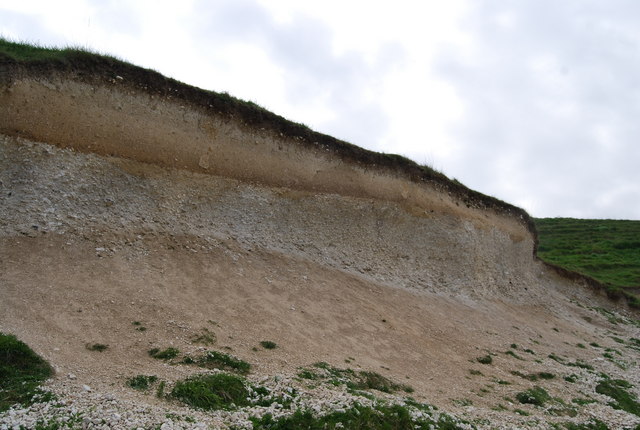
English: Calcareous Soil Profile, Seven Sisters Country Park A well defined soil profile on chalk.
The dark organic ricn humus layer can clearly be seen at the top of the profile. below it is a bleached horizon where nutrients have been leached out & below this is a darker reddish layer of redeposition. At the base of the profile is the weathered bedrock (chalk)the unweathered chalk is hidden. This soil profile is a Rendzina Rendzina |
| Rana | |
| Masomi | From geograph.org.uk |
| Marubucin | Nigel Chadwick |
| Camera location | | View this and other nearby images on: OpenStreetMap |
|---|
_heading:135.00&language=ha)
| Object location | | View this and other nearby images on: OpenStreetMap |
|---|
_heading:135.00&language=ha)
Lasisi

|
This image was taken from the Geograph project collection. See this photograph's page on the Geograph website for the photographer's contact details. The copyright on this image is owned by Nigel Chadwick and is licensed for reuse under the Creative Commons Attribution-ShareAlike 2.0 license.
|
This file is licensed under the Creative Commons Attribution-Share Alike 2.0 Generic license.
Jinginarwa: Nigel Chadwick
- Za ka iya:
- a raba – dan kwafa, yadawa da aika aikin
- dan maimaita – dan daukar aikin
- A karkashin wannan sharuddan
- Jinginarwa – Dole ku bada jinjina da ta dace, samar da linki zuwa lasisin, da kuma bayyana ko kunyi sauyi. Zaku iya haka ta yadda ta dace, amma ba kowace hanya ba wanda zai nuna mai-lasisin yana goyon bayan ku ba ko goyon bayan amfanin da kuke yi ba.
- Yada ahaka – Idan kuka maimaita, sabuntawa, ko kari akan wannan, dole ku bayar da gudunmuwar ku karkashin iri daya ko lasisi data dace kamar na asali.
Tarihin fayil
Ku latsa rana/lokaci ku ga fayil yadda yake a wannan lokaci
| Rana/Lokaci | Wadar sufa | Kusurwowi | Ma'aikaci | Bahasi | |
|---|---|---|---|---|---|
| na yanzu | 05:41, 27 ga Faburairu, 2011 | | 640 × 430 (70 KB) | GeographBot | == {{int:filedesc}} == {{Information |description={{en|1=Calcareous Soil Profile, Seven Sisters Country Park A well defined soil profile on chalk. The dark organic ricn humus layer can clearly be seen at the top of the profile. below it is a bleached hor |
Amfani da fayil
Wadannan shafi na amfani wannan fayil:
Amfanin fayil a ko'ina
Wadannan sauran wikis suna amfani da fayil din anan
- Amfani a kan ar.wikipedia.org
- Amfani a kan bn.wikipedia.org
- Amfani a kan cy.wikipedia.org
- Amfani a kan de.wikipedia.org
- Amfani a kan en.wikipedia.org
- Amfani a kan es.wikipedia.org
- Amfani a kan fa.wikipedia.org
- Amfani a kan fi.wikipedia.org
- Amfani a kan la.wikipedia.org
- Amfani a kan mk.wikipedia.org
- Amfani a kan pa.wikipedia.org
- Amfani a kan si.wikipedia.org
- Amfani a kan zh-yue.wikipedia.org