
File:Estuaries, Northwest Coast of Madagascar.JPG
Yanayin wannan rigayi gani: 398 × 599 pixels. Wasu yarjejeniyoyi: 159 × 240 pixels | 319 × 480 pixels | 510 × 768 pixels | 680 × 1,024 pixels | 1,360 × 2,048 pixels | 2,848 × 4,288 pixels.
Hoton asali (pikisal 2,848 × 4,288, girman fayil: 13.29 MB, irin MIME: image/jpeg)
Taƙaici
| Bayani |
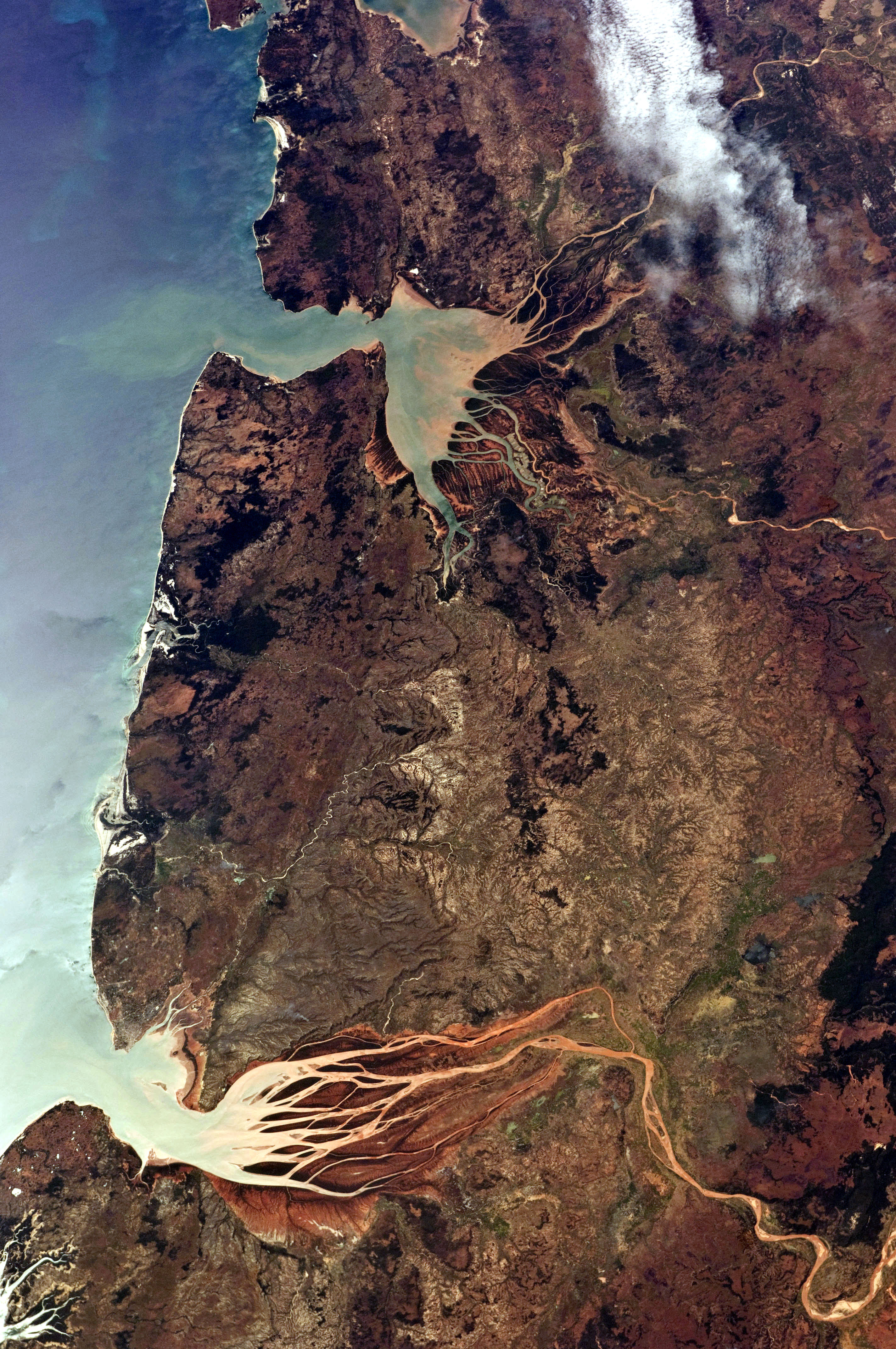
English: This astronaut photograph, taken from the International Space Station, highlights two estuaries along the north-western coastline of Madagascar. Bombetoka Bay (image upper left) is fed by the Betsiboka River, and is a frequent subject of astronaut photography due to its striking red floodplain sediments. Mahajamba Bay (image right) is fed by several rivers, including the Mahajamba and Sofia. |
| Rana | |
| Masomi | NASA Earth Observatory |
| Marubucin | ISS Astronaut photograph |
| Camera location | | View this and other nearby images on: OpenStreetMap |
|---|
This image or video was catalogued by Johnson Space Center of the United States National Aeronautics and Space Administration (NASA) under Photo ID: ISS028-E-6687. This tag does not indicate the copyright status of the attached work. A normal copyright tag is still required. See Commons:Licensing. Other languages:
|
Lasisi
| This file is in the public domain in the United States because it was solely created by NASA. NASA copyright policy states that "NASA material is not protected by copyright unless noted". (See Template:PD-USGov, NASA copyright policy page or JPL Image Use Policy.) | ||
 |
Warnings:
|
| Annotations | This image is annotated: View the annotations at Commons |
Tarihin fayil
Ku latsa rana/lokaci ku ga fayil yadda yake a wannan lokaci
| Rana/Lokaci | Wadar sufa | Kusurwowi | Ma'aikaci | Bahasi | |
|---|---|---|---|---|---|
| na yanzu | 08:00, 16 Mayu 2021 | | 2,848 × 4,288 (13.29 MB) | SteinsplitterBot | Bot: Image rotated by 270° |
| 11:30, 13 ga Yuni, 2011 |  | 4,288 × 2,848 (13.3 MB) | Originalwana | {{Information |Description ={{en|1=This astronaut photograph, taken from the International Space Station, highlights two estuaries along the north-western coastline of Madagascar. Bombetoka Bay (image upper left) is fed by the [[:Category:Betsiboka |
Amfani da fayil
Wadannan shafi na amfani wannan fayil:
Amfanin fayil a ko'ina
Wadannan sauran wikis suna amfani da fayil din anan
- Amfani a kan de.wikipedia.org
- Amfani a kan en.wikipedia.org
- Amfani a kan et.wikipedia.org
- Amfani a kan fr.wikipedia.org
- Amfani a kan mg.wikipedia.org
- Amfani a kan ml.wikipedia.org
- Amfani a kan nl.wikipedia.org
- Amfani a kan pl.wikipedia.org
- Amfani a kan pt.wikipedia.org
- Amfani a kan ro.wikipedia.org
- Amfani a kan ru.wikipedia.org
- Amfani a kan sh.wikipedia.org
- Amfani a kan sl.wikipedia.org
- Amfani a kan sr.wikipedia.org
- Amfani a kan zh.wikipedia.org