
File:Map of Attica.png

Yanayin wannan rigayi gani: 800 × 598 pixels. Wasu yarjejeniyoyi: 320 × 239 pixels | 640 × 478 pixels | 1,024 × 765 pixels | 1,280 × 957 pixels | 2,560 × 1,914 pixels | 5,711 × 4,269 pixels.
Hoton asali (pikisal 5,711 × 4,269, girman fayil: 46.76 MB, irin MIME: image/png)
Taƙaici
| Bayani |
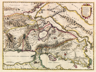
English: This is a map of Attica in a high-res scan. 1639 Hondius |
| Rana | |
| Masomi | https://www.flickr.com/photos/77434771@N08/29576644551 |
| Marubucin | Αρχείο Baldwin-Edwards |
| This image was originally posted to Flickr by Αρχείο Baldwin-Edwards at https://flickr.com/photos/77434771@N08/29576644551. It was reviewed on 1 Nuwamba 2021 by FlickreviewR 2 and was confirmed to be licensed under the terms of the cc-zero. |
Lasisi
| This file is made available under the Creative Commons CC0 1.0 Universal Public Domain Dedication. | |
| The person who associated a work with this deed has dedicated the work to the public domain by waiving all of their rights to the work worldwide under copyright law, including all related and neighboring rights, to the extent allowed by law. You can copy, modify, distribute and perform the work, even for commercial purposes, all without asking permission.
|
Tarihin fayil
Ku latsa rana/lokaci ku ga fayil yadda yake a wannan lokaci
| Rana/Lokaci | Wadar sufa | Kusurwowi | Ma'aikaci | Bahasi | |
|---|---|---|---|---|---|
| na yanzu | 19:55, 1 Nuwamba, 2021 | | 5,711 × 4,269 (46.76 MB) | BlueCat976 | Uploaded a work by Αρχείο Baldwin-Edwards from https://www.flickr.com/photos/77434771@N08/29576644551 with UploadWizard |
Amfani da fayil
Wadannan shafi na amfani wannan fayil:
Amfanin fayil a ko'ina
Wadannan sauran wikis suna amfani da fayil din anan
- Amfani a kan en.wikipedia.org