
File:Map of Jellalabad 1842.jpg
Yanayin wannan rigayi gani: 745 × 599 pixels. Wasu yarjejeniyoyi: 298 × 240 pixels | 597 × 480 pixels | 798 × 642 pixels.
Hoton asali (pikisal 798 × 642, girman fayil: 149 KB, irin MIME: image/jpeg)
Taƙaici
| Bayani |
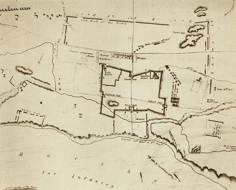
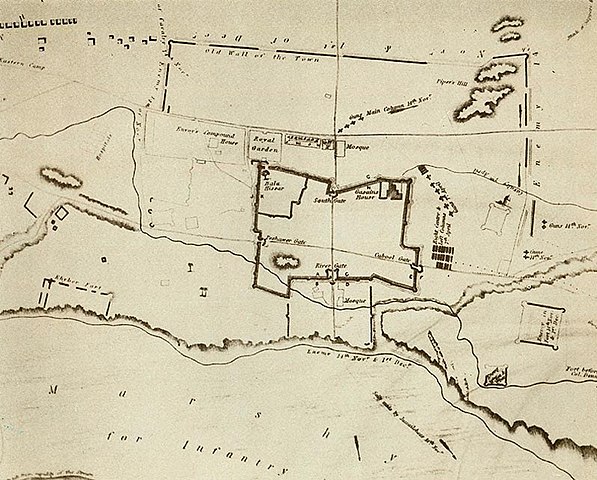
English: This map is part of an album of drawings and sketches of Afghanistan entitled 'The Defence of Jellalabad dedicated to Her majesty by the late Major-General Sir Robert Sale'. It was published around 1846 a year after Sale had been killed at the battle of Moodkee. There is no compass but north is at the base of the map where the bank of the Kabul river can just be seen near the bottom left corner. The River Gate is in the middle of the north wall, with the Kabul Gate on the west side and the Peshawar Gate on the east side. The town had shrunk as can be seen by the old wall towards the top of the map, with Piper's Hill contained in the upper right corner. |
| Rana | |
| Masomi | https://www.britishempire.co.uk/forces/armycampaigns/indiancampaigns/afghanistan1839/jellalabadmap.htm |
| Marubucin | Unknown author |
Lasisi
|
This work is in the public domain in its country of origin and other countries and areas where the copyright term is the author's life plus 70 years or fewer. This work is in the public domain in the United States because it was published (or registered with the U.S. Copyright Office) before January 1, 1929. | |
| This file has been identified as being free of known restrictions under copyright law, including all related and neighboring rights. | |
Tarihin fayil
Ku latsa rana/lokaci ku ga fayil yadda yake a wannan lokaci
| Rana/Lokaci | Wadar sufa | Kusurwowi | Ma'aikaci | Bahasi | |
|---|---|---|---|---|---|
| na yanzu | 08:38, 11 Nuwamba, 2021 | | 798 × 642 (149 KB) | Muhranoff | Uploaded a work by unnown from https://www.britishempire.co.uk/forces/armycampaigns/indiancampaigns/afghanistan1839/jellalabadmap.htm with UploadWizard |
Amfani da fayil
Wadannan shafi na amfani wannan fayil:
Amfanin fayil a ko'ina
Wadannan sauran wikis suna amfani da fayil din anan
- Amfani a kan en.wikipedia.org
- Amfani a kan ru.wikipedia.org