
File:Nigeria linguistic 1979.jpg
Yanayin wannan rigayi gani: 720 × 600 pixels. Wasu yarjejeniyoyi: 288 × 240 pixels | 576 × 480 pixels | 846 × 705 pixels.
Hoton asali (pikisal 846 × 705, girman fayil: 144 KB, irin MIME: image/jpeg)

|
File:Nigeria linguistical map 1979.svg is a vector version of this file. It should be used in place of this JPG file when not inferior.
File:Nigeria linguistic 1979.jpg → File:Nigeria linguistical map 1979.svg
For more information, see Help:SVG. |
 |
Taƙaici
| Bayani |
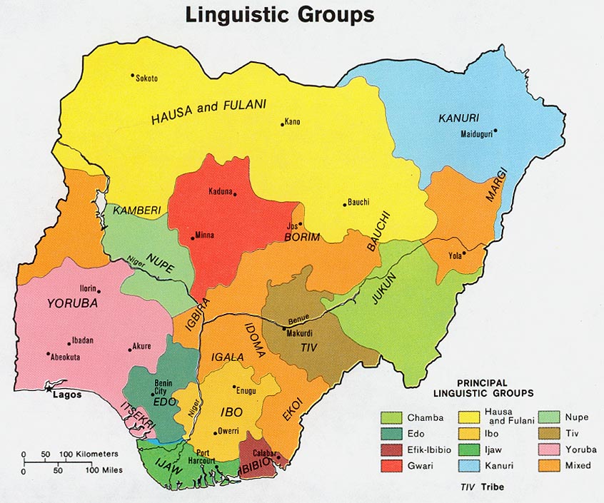
English: Map of the ethno-linguistic groups of Nigeria.
Français : Carte des groupes ethnolinguistiques du Nigeria. |
| Masomi | Perry-Castañeda Library Map Collection Nigeria maps |
| Marubucin | Central Intelligence Agency, CIA |
| Izini (Sake amfani da wannan fayil) |
[1] |
Lasisi
| This image is a work of a Central Intelligence Agency employee, taken or made as part of that person's official duties. As a Work of the United States Government, this image or media is in the public domain in the United States.
|

|
Lasisi
| This work is from the Library of Congress. According to the library, there are no known copyright restrictions on the use of this work. |  |
Tarihin fayil
Ku latsa rana/lokaci ku ga fayil yadda yake a wannan lokaci
| Rana/Lokaci | Wadar sufa | Kusurwowi | Ma'aikaci | Bahasi | |
|---|---|---|---|---|---|
| na yanzu | 23:49, 28 ga Yuni, 2006 | | 846 × 705 (144 KB) | Gozar~commonswiki | *Description: Map of the economic activity of Nigeria. *Author: Central Intelligene Agency, CIA *Source: Perry-Castañeda Library Map Collection [http://www.lib.utexas.edu/usage_statement.html?maps=yes] *Map page: [http://www.lib.utexas.edu/maps/nigeria. |
Amfani da fayil
Wadannan 3 shafuka suna amfani wannan fayil:
Amfanin fayil a ko'ina
Wadannan sauran wikis suna amfani da fayil din anan
- Amfani a kan ady.wikipedia.org
- Amfani a kan az.wiktionary.org
- qartal
- pendir
- ata
- qalay
- kitab
- məktəb
- şəhər
- insan
- it
- mələk
- həyat
- xəritə
- yemək
- iş
- soyuducu
- stul
- Azərbaycan
- Türkiyə
- dəniz
- oyuncaq
- qapı
- meymun
- mənzil
- ev
- təyyarə
- məktub
- badımcan
- bayram
- səhifə
- at
- külək
- və
- əgər
- arzu
- qara
- əl telefonu
- cənub
- abi-həyat
- abidə
- abissal
- abonent
- abordaj
- aborigen
- aberasiya
- abır
- abzas
- dövlət
- ağ
- tarix
Duba ƙarin amfanin wannan fayil.