
File:Northbound entering Gorongosa District.JPG

Yanayin wannan rigayi gani: 800 × 462 pixels. Wasu yarjejeniyoyi: 320 × 185 pixels | 640 × 369 pixels | 1,031 × 595 pixels.
Hoton asali (pikisal 1,031 × 595, girman fayil: 123 KB, irin MIME: image/jpeg)
Taƙaici
| Bayani |
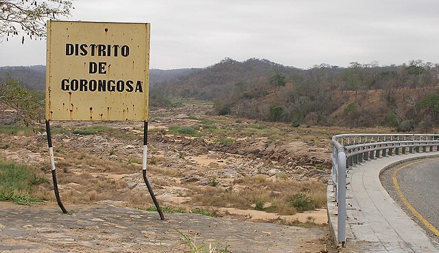
English: Travelling north on the main north-south highway of Mozambique (the EN1), entering the Gorongosa District. The bridge over the Rio Púnguè continues to the right of the photo. Note that river's low water level is typical of the late dry season. |
||
| Rana | |||
| Masomi | Aikin na | ||
| Marubucin | Brian Dell | ||
| Izini (Sake amfani da wannan fayil) |
|
| Camera location | | View this and other nearby images on: OpenStreetMap |
|---|
Tarihin fayil
Ku latsa rana/lokaci ku ga fayil yadda yake a wannan lokaci
| Rana/Lokaci | Wadar sufa | Kusurwowi | Ma'aikaci | Bahasi | |
|---|---|---|---|---|---|
| na yanzu | 08:07, 11 Nuwamba, 2008 | | 1,031 × 595 (123 KB) | Bdell555 | {{Information |Description={{en|1=Travelling north on the main north-south highway of Mozambique, entering the Gorongosa District. The bridge continues to the right of the photo. Note that the river's low water level is typical of the late dry season.}} |
Amfani da fayil
Wadannan shafi na amfani wannan fayil:
Amfanin fayil a ko'ina
Wadannan sauran wikis suna amfani da fayil din anan
- Amfani a kan ca.wikipedia.org
- Amfani a kan ceb.wikipedia.org
- Amfani a kan en.wikipedia.org
- Amfani a kan fi.wikipedia.org
- Amfani a kan ig.wikipedia.org
- Amfani a kan no.wikipedia.org
- Amfani a kan pt.wikipedia.org
- Amfani a kan ts.wikipedia.org
- Amfani a kan www.wikidata.org
- Amfani a kan yo.wikipedia.org
- Amfani a kan zh-min-nan.wikipedia.org
- Amfani a kan zh.wikipedia.org
- Amfani a kan zu.wikipedia.org