
File:Population density of Africa.jpg
Yanayin wannan rigayi gani: 650 × 600 pixels. Wasu yarjejeniyoyi: 260 × 240 pixels | 520 × 480 pixels | 738 × 681 pixels.
Hoton asali (pikisal 738 × 681, girman fayil: 84 KB, irin MIME: image/jpeg)


Taƙaici
| Bayani |
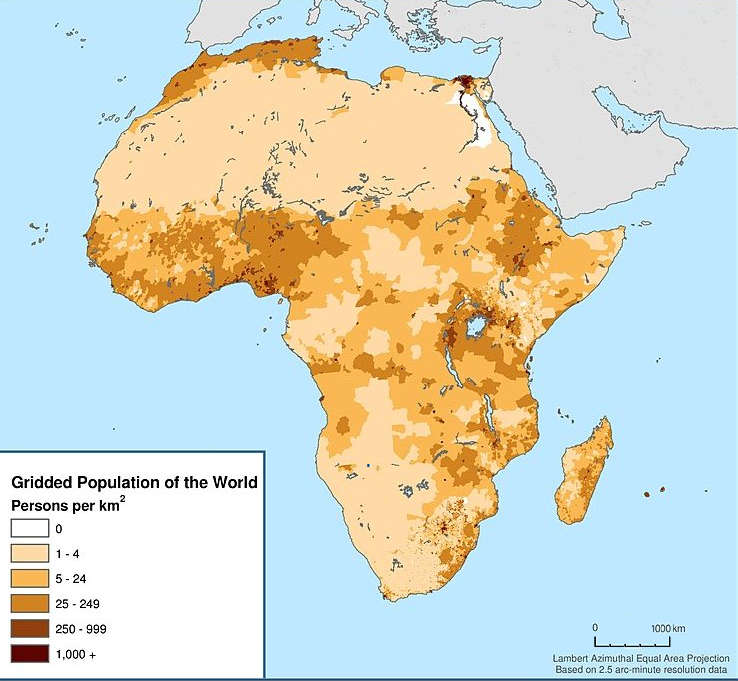
English: Map showing the population density of Africa. Title: Africa: Population Density, 2000 |
| Rana | |
| Masomi | http://sedac.ciesin.columbia.edu/data/set/gpw-v3-population-density/maps |
| Marubucin |
Center for International Earth Science Information Network - CIESIN - Columbia University, International Food Policy Research Institute - IFPRI, The World Bank, and Centro Internacional de Agricultura Tropical - CIAT. 2011. Global Rural-Urban Mapping Project, Version 1 (GRUMPv1): Urban Extents Grid (Africa). Palisades, NY: NASA Socioeconomic Data and Applications Center (SEDAC). http://sedac.ciesin.columbia.edu/data/set/grump-v1-urban-extents/maps. Accessed 12 October 2017. Source: Center for International Earth Science Information Network (CIESIN), Columbia University; and Centro Internacional de Agricultura Tropical (CIAT), Gridded Population of the World (GPW), Version 3. Palisades, NY: CIESIN, Columbia University. Available at: http://sedac.ciesin.columbia.edu/gpw." |
| Izini (Sake amfani da wannan fayil) |
CC BY 3.0. See the previous versions of this file. |
Lasisi
This file is licensed under the Creative Commons Attribution 3.0 Unported license.
- Za ka iya:
- a raba – dan kwafa, yadawa da aika aikin
- dan maimaita – dan daukar aikin
- A karkashin wannan sharuddan
- Jinginarwa – Dole ku bada jinjina da ta dace, samar da linki zuwa lasisin, da kuma bayyana ko kunyi sauyi. Zaku iya haka ta yadda ta dace, amma ba kowace hanya ba wanda zai nuna mai-lasisin yana goyon bayan ku ba ko goyon bayan amfanin da kuke yi ba.
Tarihin fayil
Ku latsa rana/lokaci ku ga fayil yadda yake a wannan lokaci
| Rana/Lokaci | Wadar sufa | Kusurwowi | Ma'aikaci | Bahasi | |
|---|---|---|---|---|---|
| na yanzu | 15:02, 18 Disamba 2017 | | 738 × 681 (84 KB) | Maproom | Removed credits, logos, etc. Lengthened scale. |
| 07:45, 12 Disamba 2017 |  | 738 × 989 (131 KB) | ديفيد عادل وهبة خليل 2 | Removed border by cropping 7 % horizontally and 3 % vertically using CropTool with precise mode. | |
| 15:28, 12 Oktoba 2017 |  | 791 × 1,024 (129 KB) | Mrmisr | User created page with UploadWizard |
Amfani da fayil
Wadannan shafi na amfani wannan fayil:
Amfanin fayil a ko'ina
Wadannan sauran wikis suna amfani da fayil din anan
- Amfani a kan en.wikipedia.org
- Amfani a kan pnb.wikipedia.org
- Amfani a kan ur.wikipedia.org
- Amfani a kan vi.wikipedia.org