
File:Roman Africa.JPG
Hoton asali (pikisal 3,057 × 2,439, girman fayil: 1.95 MB, irin MIME: image/jpeg)
Taƙaici
| Bayani |
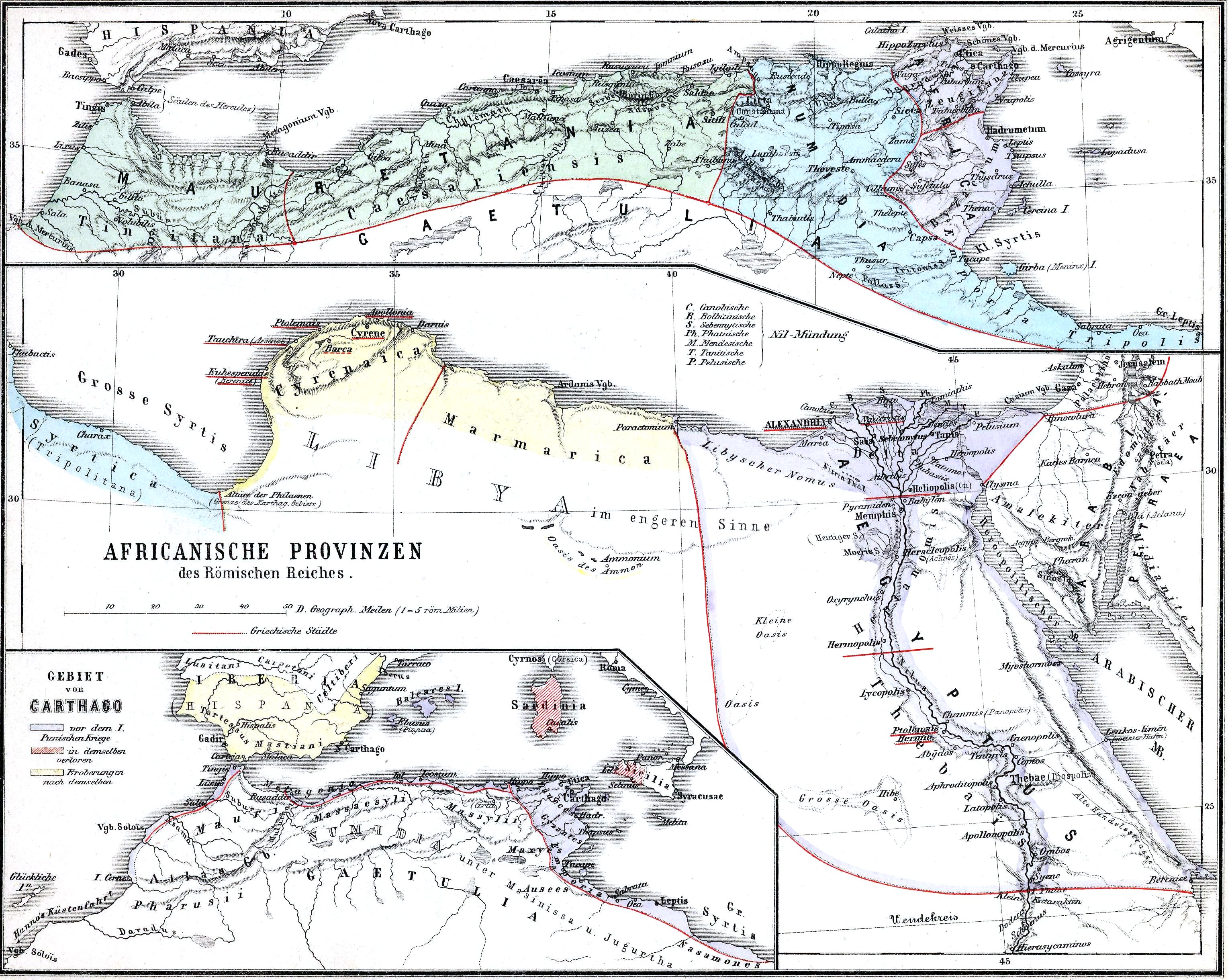
English: The African provinces of the Roman Empire. The smaller map in the lower left shows the territory of the pre-Roman state of Carthage (blue), with yellow showing conquests and hashed red indicating territory lost to Rome in the First Punic War. |
| Rana | |
| Masomi | Historischer Schulatlas. |
| Marubucin | H. Kiepert |
Lasisi
|
This work is in the public domain in its country of origin and other countries and areas where the copyright term is the author's life plus 70 years or fewer.
| |
| This file has been identified as being free of known restrictions under copyright law, including all related and neighboring rights. | |
Tarihin fayil
Ku latsa rana/lokaci ku ga fayil yadda yake a wannan lokaci
| Rana/Lokaci | Wadar sufa | Kusurwowi | Ma'aikaci | Bahasi | |
|---|---|---|---|---|---|
| na yanzu | 15:37, 15 Nuwamba, 2009 | | 3,057 × 2,439 (1.95 MB) | Alex:D | whitened |
| 22:37, 14 ga Faburairu, 2009 |  | 3,057 × 2,439 (1.55 MB) | Olahus | {{Information |Description=Nothern Africa under Roman rule. |Source=Historischer Schulatlas. |Date=1879 |Author=H.Kiepert |Permission= |other_versions= }} {{PD-old}} Category:Old maps of Africa Category:Old maps of the Roman Empire [[Category:Maps |
Amfani da fayil
Wadannan shafi na amfani wannan fayil:
Amfanin fayil a ko'ina
Wadannan sauran wikis suna amfani da fayil din anan
- Amfani a kan ar.wikipedia.org
- Amfani a kan arz.wikipedia.org
- Amfani a kan bg.wikipedia.org
- Amfani a kan ca.wikipedia.org
- Amfani a kan cs.wikipedia.org
- Amfani a kan de.wikipedia.org
- Amfani a kan de.wikivoyage.org
- Amfani a kan de.wiktionary.org
- Amfani a kan el.wikipedia.org
- Amfani a kan en.wikipedia.org
- Numidia
- North Africa during classical antiquity
- Roman Egypt
- Byzacena
- Myos Hormos
- Tacfarinas
- List of revolutions and rebellions
- Aquae Regiae
- User:Olahus
- Uzita (Tunisia)
- El Milia
- Aggersel
- Quiza Xenitana
- Berber kings of Roman-era Tunisia
- Diocese of Maxita
- Aquae Albae in Byzacena
- Decoriana
- Simminensis (diocese)
- Zerta
- Titular Bishopric of Vita
- Elephantaria in Mauretania
- Tubia in Mauretania
- Tabuda
- Lari Castellum
- User:Ryanmhorne/pleiades List
- Ancient Africa
- Amfani a kan eo.wikipedia.org
- Amfani a kan es.wikipedia.org
- Amfani a kan et.wikipedia.org
- Amfani a kan eu.wikipedia.org
- Amfani a kan fa.wikipedia.org
- Amfani a kan fr.wikipedia.org
Duba ƙarin amfanin wannan fayil.