
File:Stratigraphy of the Grand Canyon.png

Yanayin wannan rigayi gani: 439 × 599 pixels. Wasu yarjejeniyoyi: 176 × 240 pixels | 600 × 819 pixels.
Hoton asali (pikisal 600 × 819, girman fayil: 1.48 MB, irin MIME: image/png)
Taƙaici
| Bayani |
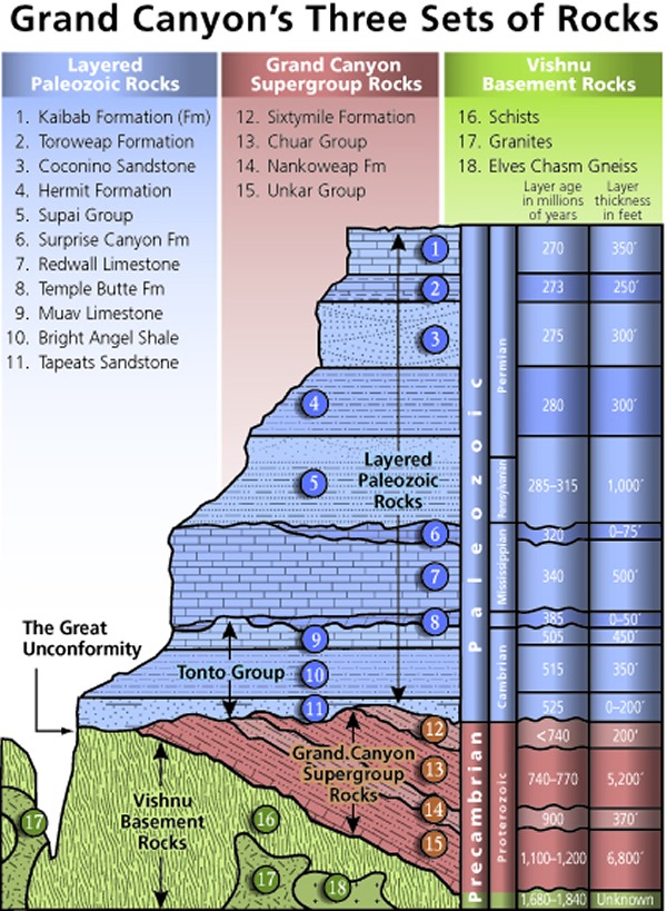
Stratigraphy of the Grand Canyon. "Grand Canyon 'yardstick' of geologic time: A guide to the canyon’s geologic history and origin." |
| Masomi | https://www.nps.gov/articles/images/pop-up-yardstick.jpg |
| Marubucin | Mathis, A. 2006. Grand Canyon Association, Grand Canyon, Arizona, USA. |
| Izini (Sake amfani da wannan fayil) |
PD-USGov, see below and http://www.nps.gov/disclaimer.htm |
Lasisi
| This image or media file contains material based on a work of a United States Department of the Interior employee, created as part of that person's official duties. As a work of the U.S. federal government, such work is in the public domain in the United States. See the Department of the Interior copyright policy for more information. |  |
Tarihin fayil
Ku latsa rana/lokaci ku ga fayil yadda yake a wannan lokaci
| Rana/Lokaci | Wadar sufa | Kusurwowi | Ma'aikaci | Bahasi | |
|---|---|---|---|---|---|
| na yanzu | 22:39, 11 ga Maris, 2008 | | 600 × 819 (1.48 MB) | Jo Weber | {{Information |Description=Stratigraphy of the Grand Canyon |Source=http://www.nature.nps.gov/geology/parks/grca/age/image_popup/yardstickstratcolumn.png |Date= |Author= |Permission=PD-USGov, see below and http://www.nps.gov/disclaimer.htm |other_versions |
Amfani da fayil
Wadannan shafi na amfani wannan fayil:
Amfanin fayil a ko'ina
Wadannan sauran wikis suna amfani da fayil din anan
- Amfani a kan ar.wikipedia.org
- Amfani a kan az.wikipedia.org
- Amfani a kan bs.wikipedia.org
- Amfani a kan ca.wikipedia.org
- Amfani a kan en.wikipedia.org
- Amfani a kan fa.wikipedia.org
- Amfani a kan fr.wikipedia.org
- Amfani a kan he.wikipedia.org
- Amfani a kan id.wikipedia.org
- Amfani a kan mk.wikipedia.org
- Amfani a kan pl.wikipedia.org
- Amfani a kan ru.wikipedia.org
- Amfani a kan simple.wikipedia.org
- Amfani a kan sl.wikipedia.org
- Amfani a kan te.wikipedia.org
- Amfani a kan www.wikidata.org