
File:WF -Hoorn.png
Babu wata babbar saƙa.
WF_-Hoorn.png (pikisal 500 × 500, girman fayil: 16 KB, irin MIME: image/png)
Taƙaici
| Bayani |
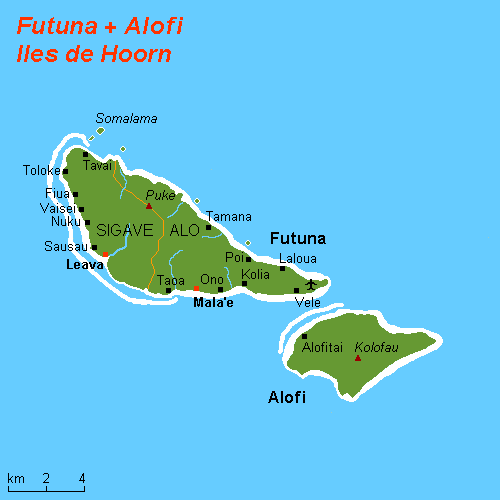
English: Map (rough) Hoorn Islands, Wallis and Futuna, own work composed from various mapreferences |
| Rana | |
| Masomi | Aikin na |
| Marubucin | Hobe / Holger Behr |
| Izini (Sake amfani da wannan fayil) |
Public domain |
Lasisi
| I, the copyright holder of this work, release this work into the public domain. This applies worldwide. In some countries this may not be legally possible; if so: I grant anyone the right to use this work for any purpose, without any conditions, unless such conditions are required by law. |
Tarihin fayil
Ku latsa rana/lokaci ku ga fayil yadda yake a wannan lokaci
| Rana/Lokaci | Wadar sufa | Kusurwowi | Ma'aikaci | Bahasi | |
|---|---|---|---|---|---|
| na yanzu | 18:12, 13 Oktoba 2012 | | 500 × 500 (16 KB) | Bazonka | Remove co-ordinates. They weren't remotely accurate. |
| 11:06, 31 Oktoba 2010 |  | 500 × 500 (10 KB) | Hobe | removed borders | |
| 18:47, 25 ga Maris, 2008 |  | 500 × 500 (10 KB) | Hobe | {{Information |Description=map Hoorn Islands (rough), Wallis and Futuna |Source=self-made, composed from various mapreferences |Date=2008-03-23 |Author= Hobe |Permission= |other_versions= Category:Wallis and Futuna }} |
Amfani da fayil
Wadannan shafi na amfani wannan fayil:
Amfanin fayil a ko'ina
Wadannan sauran wikis suna amfani da fayil din anan
- Amfani a kan ca.wikipedia.org
- Amfani a kan de.wikivoyage.org
- Amfani a kan en.wikipedia.org
- Amfani a kan es.wikipedia.org
- Amfani a kan et.wikipedia.org
- Amfani a kan fa.wikipedia.org
- Amfani a kan fi.wikipedia.org
- Amfani a kan gl.wikipedia.org
- Amfani a kan id.wikipedia.org
- Amfani a kan it.wikipedia.org
- Amfani a kan it.wikivoyage.org
- Amfani a kan ja.wikipedia.org
- Amfani a kan ka.wikipedia.org
- Amfani a kan la.wikipedia.org
- Amfani a kan lt.wikipedia.org
- Amfani a kan mk.wikipedia.org
- Amfani a kan nl.wikipedia.org
- Amfani a kan pnb.wikipedia.org
Duba ƙarin amfanin wannan fayil.