
Fayil:11-09-fotofluege-cux-allg-25a.jpg

Yanayin wannan rigayi gani: 600 × 600 pixels. Wasu yarjejeniyoyi: 240 × 240 pixels | 480 × 480 pixels | 768 × 768 pixels | 1,024 × 1,024 pixels | 2,048 × 2,048 pixels | 2,848 × 2,848 pixels.
Hoton asali (pikisal 2,848 × 2,848, girman fayil: 5.53 MB, irin MIME: image/jpeg)
Taƙaici
| Bayani |
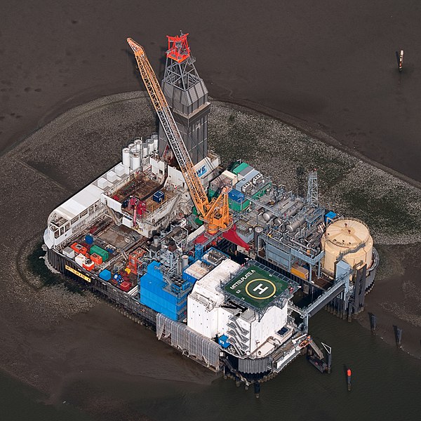
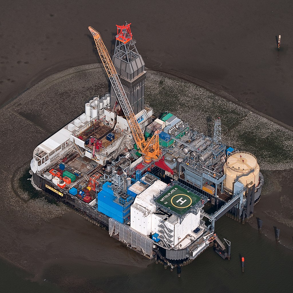
Deutsch: Fotoflug Nordsee; Ölbohrinsel im Ölfeld Mittelplate
English: Germany’s largest oil field Mittelplate
Español: Vista aérea de la plataforma petrolera de Mittelplate, el mayor yacimiento petrolífero de Alemania.
Français : Vue aérienne de Mittelplate, le plus grand champ pétrolifère d'Allemagne
Polski: Platforma wiertnicza na największym niemieckim polu naftowym „Mittelplate” znajdującym się na Morzu Północnym.
Português: Vista aérea da plataforma petrolífera de Mittelplate, o maior campo de petróleo da Alemanha. |
|||||||||||||||||||||||
| Rana | ||||||||||||||||||||||||
| Masomi | Aikin na | |||||||||||||||||||||||
| Marubucin |
|
|||||||||||||||||||||||
| Izini (Sake amfani da wannan fayil) |
|
|||||||||||||||||||||||
| Other versions |
 |
|||||||||||||||||||||||

| Camera location | | View this and other nearby images on: OpenStreetMap |
|---|
Assessment
|
This image was selected as picture of the day on Wikimedia Commons for 2 February 2016. It was captioned as follows: English: Germany’s largest oil field Mittelplate Other languages:
Bosanski: Najveće naftno polje u Njemačkoj, Mittelplate Català: Mittelplate, el camp petrolier més gran d'Alemanya. Deutsch: Fotoflug Nordsee; Ölbohrinsel im Ölfeld Mittelplate English: Germany’s largest oil field Mittelplate Español: Vista aérea de la plataforma petrolera de Mittelplate, el mayor yacimiento petrolífero de Alemania. Italiano: Vista aerea della piattaforma petrolifera di Mittelplate, il principale giacimento petrolifero tedesco. Português: Vista aérea da plataforma petrolífera de Mittelplate, o maior campo de petróleo da Alemanha. Suomi: Mittelplate, suurin öljykentän Saksan. Македонски: Мителплате — најголемото нафтено поле во Германија. Русский: Миттельплате, крупнейшее месторождение нефти Германии. 한국어: 독일에서 가장 큰 유전 미텔플라테. 中文: 德国最大油井 Mittelplate 中文(繁體): 德國最大油井 Mittelplate |
Lasisi
| Dieses Foto entstand aufgrund eines Projektes, das von Wikimedia Deutschland e. V. gefördert wurde.
Im Rahmen des „Community-Projektbudgets“ sollen Luftbilder u.a. von Inseln, Halligen, Sanden und Küstenorten der deutschen Nordseeküste angefertigt werden. Das Projekt „Fotoflüge“ wurde im September 2011 begonnen. |
This file is licensed under the Creative Commons Attribution-Share Alike 3.0 Germany license.
- Za ka iya:
- a raba – dan kwafa, yadawa da aika aikin
- dan maimaita – dan daukar aikin
- A karkashin wannan sharuddan
- Jinginarwa – Dole ku bada jinjina da ta dace, samar da linki zuwa lasisin, da kuma bayyana ko kunyi sauyi. Zaku iya haka ta yadda ta dace, amma ba kowace hanya ba wanda zai nuna mai-lasisin yana goyon bayan ku ba ko goyon bayan amfanin da kuke yi ba.
- Yada ahaka – Idan kuka maimaita, sabuntawa, ko kari akan wannan, dole ku bayar da gudunmuwar ku karkashin iri daya ko lasisi data dace kamar na asali.

Tarihin fayil
Ku latsa rana/lokaci ku ga fayil yadda yake a wannan lokaci
| Rana/Lokaci | Wadar sufa | Kusurwowi | Ma'aikaci | Bahasi | |
|---|---|---|---|---|---|
| na yanzu | 20:40, 13 ga Janairu, 2015 | | 2,848 × 2,848 (5.53 MB) | Ralf Roletschek | volle Auflösung aus Original |
| 17:13, 28 ga Faburairu, 2013 |  | 2,848 × 2,848 (3.94 MB) | Jkadavoor | Reverted to version as of 21:23, 4 September 2011 per Commons:Overwriting_existing_files#DO_NOT_overwrite : Files that have been awarded a special status like Commons Featured Picture, or similar status on another Wikimedia project. Such files are ... | |
| 15:32, 21 ga Faburairu, 2013 |  | 5,932 × 5,932 (14.62 MB) | Ralf Roletschek | größere Version | |
| 21:23, 4 Satumba 2011 |  | 2,848 × 2,848 (3.94 MB) | Ralf Roletschek | {{Information |Description=Fotoflug Nordsee |Source={{own}} |Date=2011-09-04 |Author=Ralf Roletschek (<span class="signature-talk">talk</span>) |Permission= |other_versions=[[File:11-09-fotofluege-cux |
Amfani da fayil
Wadannan shafi na amfani wannan fayil:
Amfanin fayil a ko'ina
Wadannan sauran wikis suna amfani da fayil din anan
- Amfani a kan ar.wikipedia.org
- Amfani a kan ar.wikinews.org
- Amfani a kan be-tarask.wikipedia.org
- Amfani a kan bg.wikipedia.org
- Amfani a kan ca.wikipedia.org
- Amfani a kan ceb.wikipedia.org
- Amfani a kan crh.wikipedia.org
- Amfani a kan cs.wikipedia.org
- Amfani a kan cv.wikipedia.org
- Amfani a kan da.wikipedia.org
- Amfani a kan de.wikipedia.org
- Wattenmeer (Nordsee)
- Erdöl
- Luftbildfotografie
- Bohrinsel
- Erdölförderung in Deutschland
- Mittelplate (Ölfeld)
- Friedrichskoog
- Nordseeöl
- Recht am Bild der eigenen Sache
- Wikipedia:Projekt Fotoflüge/2011/September
- Wikipedia:Projekt Fotoflüge/Ergebnisse
- Wikipedia Diskussion:Projekt Fotoflugkurs Cuxhaven 2013
- Wikipedia:AdminConvention 2016/Teilnehmer
- Benutzer:Artikelstube/Liste von Bauverfahren
- Amfani a kan de.wikiversity.org
- Amfani a kan de.wikivoyage.org
- Amfani a kan el.wikipedia.org
- Amfani a kan en.wikipedia.org
- Oil platform
- North Sea oil
- Wikipedia:WikiProject Energy
- Mittelplate
- Wikipedia:Featured pictures/Places/Architecture
- Marine architecture
- User talk:Ralf Roletschek
- User talk:Nikhil B
- Wikipedia:WikiProject Energy/Recognized content
- Portal:Energy/Explore/Recognized content
- Accommodation platform
- Wikipedia:Featured pictures thumbs/59
- Wikipedia:Featured picture candidates/November-2016
- Wikipedia:Featured picture candidates/Mittelplate
- Wikipedia:Wikipedia Signpost/2016-11-26/Featured content
- Wikipedia:Wikipedia Signpost/Single/2016-11-26
Duba ƙarin amfanin wannan fayil.