
Fayil:AT0103 map.png

Yanayin wannan rigayi gani: 663 × 599 pixels. Wasu yarjejeniyoyi: 266 × 240 pixels | 531 × 480 pixels | 915 × 827 pixels.
Hoton asali (pikisal 915 × 827, girman fayil: 27 KB, irin MIME: image/png)
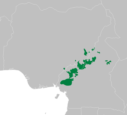
Taƙaici
| Bayani | Cameroonian Highlands forests ecoregion map |
| Rana | |
| Masomi | Aikin na |
| Marubucin | Altatoron |
Lasisi
| I, the copyright holder of this work, release this work into the public domain. This applies worldwide. In some countries this may not be legally possible; if so: I grant anyone the right to use this work for any purpose, without any conditions, unless such conditions are required by law. |
Tarihin fayil
Ku latsa rana/lokaci ku ga fayil yadda yake a wannan lokaci
| Rana/Lokaci | Wadar sufa | Kusurwowi | Ma'aikaci | Bahasi | |
|---|---|---|---|---|---|
| na yanzu | 08:42, 11 Mayu 2007 | | 915 × 827 (27 KB) | Doreano~commonswiki | {{Information |Description=Cameroonian Highlands forests ecoregion map |Source=self made |Date=2007/5/11 |Author=Altatoron |Permission= |other_versions= }} |
Amfani da fayil
Wadannan shafi na amfani wannan fayil:
Amfanin fayil a ko'ina
Wadannan sauran wikis suna amfani da fayil din anan
- Amfani a kan be.wikipedia.org
- Amfani a kan ca.wikipedia.org
- Amfani a kan eo.wikipedia.org
- Amfani a kan es.wikipedia.org
- Amfani a kan ig.wikipedia.org
- Amfani a kan it.wikipedia.org
- Amfani a kan ru.wikipedia.org
- Amfani a kan www.wikidata.org