
Fayil:America noviter delineata.jpg
Hoton asali (pikisal 5,965 × 4,528, girman fayil: 5.17 MB, irin MIME: image/jpeg)
Taƙaici
| Description |
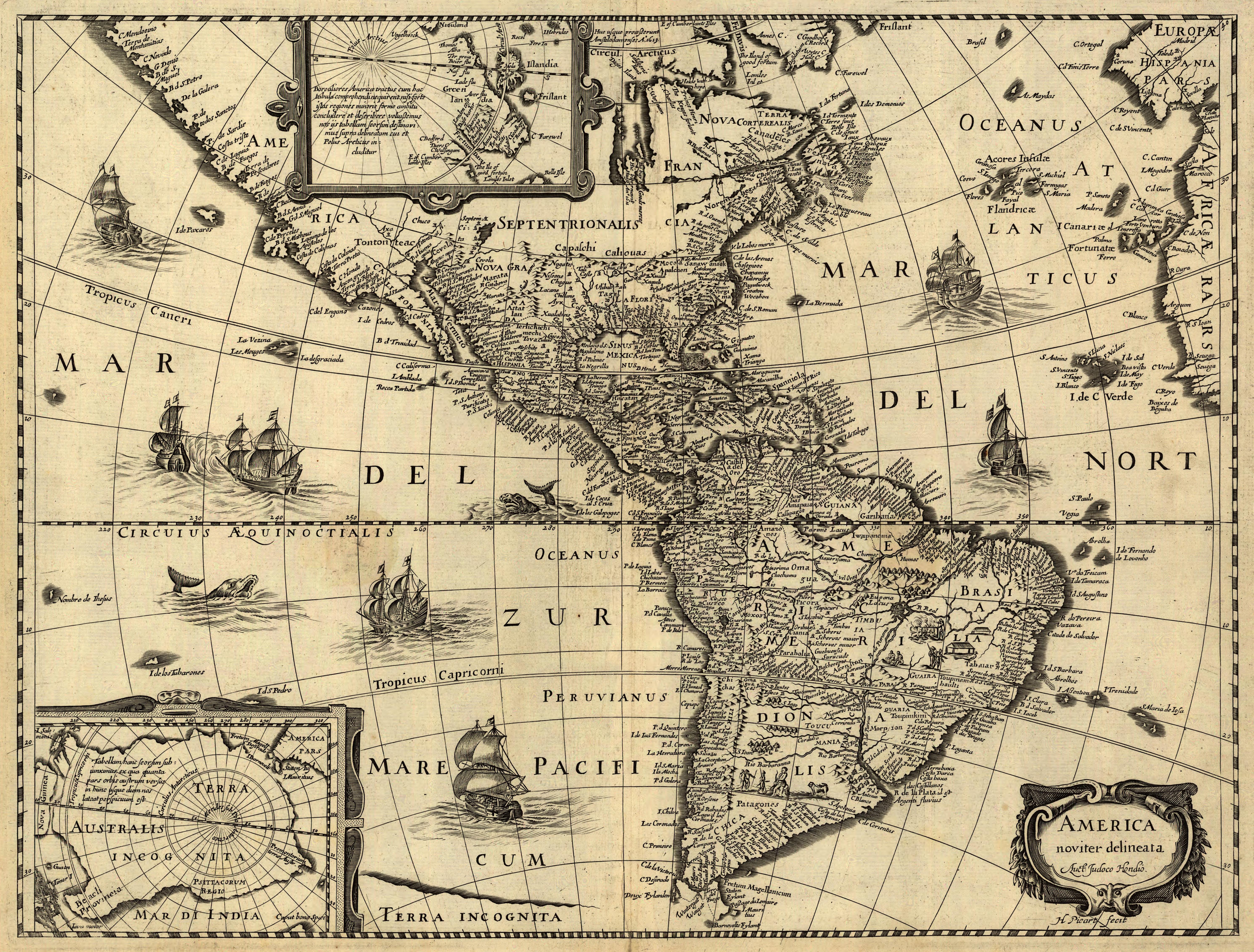
Latina: America noviter delineata / auct. Jodoco Hondio; H. Picard fecit.
English: America newly delineated / by Jodocus Hondius; engraved by H. Picard. A 17th-century map of the Americas. Scale ca. 1:45,000,000. Map ranges from W 125°–W 5° and N 70°–S 60°. Also includes insets of the polar regions.
Français : L'amérique nouvellement cartographiée / Par Jocodus Hondius; gravé par H. Picard. Une carte des amériques du XVIIe siècle. Echelle: environ 1:45 000 000. La carte couvre un espace allant de 5°W à 125°W et de 60°S à 70°N. Elle inclut aussi en encarts les régions polaires. |
|||||
| Masomi |
Published by Jean Boisseau. The U.S. Library of Congress gives the date of publication as "1640?", while another source suggests a first publication of 1637 or 1639. Digital version produced by the U.S. Library of Congress Geography and Map Division. JPEG 2000 source image converted to JPEG by User:Delirium using JasPer 1.701.0, since JPEG 2000 is not as of this uploading supported on Commons.
|
|||||
| Maƙirƙiri |
Jodocus Hondius (1563-1612) |
|||||
| Izini (Sake amfani da wannan fayil) |
|
|||||
| Georeferencing | If inappropriate please set warp_status = skip to hide. | |||||

Awards
|

This image was selected as picture of the day on Wikimedia Commons for 17 April 2007. It was captioned as follows: Other languages:
Español: America noviter delineata, un mapa de América del siglo XVII realizado por Jodocus Hondius. Esperanto: America noviter delineata, mapo de Ameriko desegnita en la 17-a jarcento de Jodocus Hondius. Français : America noviter delineata, une carte du XVIIe siècle des Amériques, dressée par Jodocus Hondius Italiano: America noviter delineata, una mappa delle Americhe realizzata nel XVII secolo da Jodocus Hondius. Magyar: America noviter delineata, 17. századi térkép Amerikáról, Jodocus Hondiusalkotása Nederlands: America noviter delineata, kaart uit de 17e eeuw van het continent Amerika door de cartograaf Jodocus Hondius Polski: America noviter delineata, siedemnastowieczna mapa Ameryki autorstwa Jodocusa Hondiusa (1563-1611) Suomi: America noviter delineata, Jodocus Hondiuksen tekemä Amerikankartta 1600-luvulta Svenska: America noviter delineata är en karta över Amerika ritad på 1600-talet av den flamländske kartografen Jodocus Hondius. 日本語: America noviter delineata、Jodocus Hondiusによる17世紀のアメリカの地図。 中文(繁體): 17世紀時由約道庫斯·洪地烏斯繪製的《最新美洲地圖》 |
Tarihin fayil
Ku latsa rana/lokaci ku ga fayil yadda yake a wannan lokaci
| Rana/Lokaci | Wadar sufa | Kusurwowi | Ma'aikaci | Bahasi | |
|---|---|---|---|---|---|
| na yanzu | 06:33, 14 ga Yuni, 2006 | | 5,965 × 4,528 (5.17 MB) | Delirium | ''America noviter delineata / auct. Jodoco Hondio; H. Picard fecit.'' (America newly delineated / by Jodoco Hondia; engraved by H. Picard.) A 17th-century map of the Americas. Scale ca. 1:45,000,000. Map ranges from W 125°–W 5° and N 70&d |
Amfani da fayil
Wadannan 3 shafuka suna amfani wannan fayil:
Amfanin fayil a ko'ina
Wadannan sauran wikis suna amfani da fayil din anan
- Amfani a kan af.wikipedia.org
- Amfani a kan ar.wikipedia.org
- Amfani a kan ba.wikipedia.org
- Amfani a kan bcl.wikipedia.org
- Amfani a kan bn.wikipedia.org
- Amfani a kan ca.wikipedia.org
- Amfani a kan en.wikipedia.org
- Spanish colonization of the Americas
- History of Latin America
- Portal:Latin America
- Portal talk:Latin America
- Talk:History of Latin America/Sandbox
- Portal:Latin America/Featured picture list
- Portal:Latin America/Featured picture/1
- History of navigation
- Talk:History of South America/sandbox
- Historiography of Colonial Spanish America
- Cartography of Latin America
- Economic history of Latin America
- Amfani a kan eo.wikipedia.org
- Amfani a kan es.wikipedia.org
- Amfani a kan es.wikiversity.org
- Amfani a kan eu.wikipedia.org
- Amfani a kan fa.wikipedia.org
- Amfani a kan fr.wikipedia.org
- Amfani a kan gl.wikipedia.org
Duba ƙarin amfanin wannan fayil.