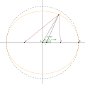
Fayil:Geocentric vs geodetic latitude.svg
Appearance

Size of this PNG preview of this SVG file: 600 × 600 pixels. Wasu yarjejeniyoyi: 240 × 240 pixels | 480 × 480 pixels | 768 × 768 pixels | 1,024 × 1,024 pixels | 2,048 × 2,048 pixels | 792 × 792 pixels.
Hoton asali (Fayil kin SVG, saƙar fikisal 792 x 792, girman fayil: 52 KB)
Tarihin fayil
Ku latsa rana/lokaci ku ga fayil yadda yake a wannan lokaci
| Rana/Lokaci | Wadar sufa | Kusurwowi | Ma'aikaci | Bahasi | |
|---|---|---|---|---|---|
| na yanzu | 19:40, 3 ga Maris, 2021 |  | 792 × 792 (52 KB) | Datumizer | Rename some variables. Adjust scale. |
| 21:07, 19 ga Yuli, 2018 |  | 786 × 786 (32 KB) | Datumizer | Label the points differently. | |
| 05:36, 6 ga Augusta, 2008 |  | 300 × 300 (38 KB) | Datumizer | text too dark | |
| 05:34, 6 ga Augusta, 2008 |  | 300 × 300 (38 KB) | Datumizer | removed accidental purple text | |
| 05:33, 6 ga Augusta, 2008 |  | 300 × 300 (38 KB) | Datumizer | Image is now more readable | |
| 04:41, 15 ga Faburairu, 2008 |  | 500 × 500 (35 KB) | Datumizer | Switched to showing the same coordinate with different angles instead of the same angle with different coordinates. | |
| 04:32, 15 ga Faburairu, 2008 |  | 500 × 500 (37 KB) | Datumizer | Try and get rid of background. | |
| 04:22, 15 ga Faburairu, 2008 |  | 500 × 500 (38 KB) | Datumizer | {{Information |Description=Shows the difference between latitude coordinates on an oblate spheroid (such as the Earth) when using the geocentric and geodetic coordinate systems. |Source=self-made |Date=2008-02-14 |Author= SharkD |Permissio |
Amfani da fayil
Wadannan shafi na amfani wannan fayil:
Amfanin fayil a ko'ina
Wadannan sauran wikis suna amfani da fayil din anan
- Amfani a kan bn.wikipedia.org
- Amfani a kan ca.wikipedia.org
- Amfani a kan el.wikipedia.org
- Amfani a kan en.wikipedia.org
- Amfani a kan la.wikipedia.org


