Fayil:Mackenzie River Outflow.jpg
Appearance

Yanayin wannan rigayi gani: 670 × 599 pixels. Wasu yarjejeniyoyi: 268 × 240 pixels | 537 × 480 pixels | 858 × 768 pixels | 1,145 × 1,024 pixels | 2,289 × 2,048 pixels | 7,600 × 6,800 pixels.
Hoton asali (pikisal 7,600 × 6,800, girman fayil: 91.24 MB, irin MIME: image/jpeg)
Tarihin fayil
Ku latsa rana/lokaci ku ga fayil yadda yake a wannan lokaci
| Rana/Lokaci | Wadar sufa | Kusurwowi | Ma'aikaci | Bahasi | |
|---|---|---|---|---|---|
| na yanzu | 09:35, 7 ga Yuni, 2021 |  | 7,600 × 6,800 (91.24 MB) | StellarHalo | higher resolution |
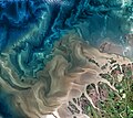
| 07:34, 7 ga Janairu, 2021 |  | 1,920 × 1,718 (2.89 MB) | StellarHalo | {{Information |Description=The Mackenzie River in Canada plays a major role in Arctic climate as warmer fresh water mixes with cold seawater. |Source=https://climate.nasa.gov/climate_resources/158/mackenzie-river/ |Date=July 18, 2017. |Author=Operational Land Imager on the Landsat 8 satellite |Permission= |other_versions= }} Category:Satellite pictures of the Northwest Territories |
Amfani da fayil
Wadannan shafi na amfani wannan fayil:
Amfanin fayil a ko'ina
Wadannan sauran wikis suna amfani da fayil din anan
- Amfani a kan fr.wikipedia.org


