
Fayil:Mauritania Topography.png

Yanayin wannan rigayi gani: 589 × 600 pixels. Wasu yarjejeniyoyi: 236 × 240 pixels | 472 × 480 pixels | 754 × 768 pixels | 1,006 × 1,024 pixels | 1,843 × 1,876 pixels.
Hoton asali (pikisal 1,843 × 1,876, girman fayil: 2.73 MB, irin MIME: image/png)
Taƙaici
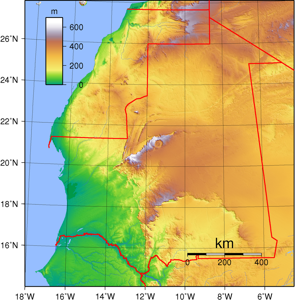
| Bayani | Topography of Mauritania. Created with GMT from GLOBE data. |
| Rana | |
| Masomi | Aikin na |
| Marubucin | Sadalmelik |
| Other versions | Derivative works of this file: Richat Structure in Mauritania Topographic map.jpg |
Lasisi
| This work has been released into the public domain by its author, I, Sadalmelik. This applies worldwide. In some countries this may not be legally possible; if so: I, Sadalmelik grants anyone the right to use this work for any purpose, without any conditions, unless such conditions are required by law. |
Tarihin fayil
Ku latsa rana/lokaci ku ga fayil yadda yake a wannan lokaci
| Rana/Lokaci | Wadar sufa | Kusurwowi | Ma'aikaci | Bahasi | |
|---|---|---|---|---|---|
| na yanzu | 20:33, 29 ga Yuni, 2007 | | 1,843 × 1,876 (2.73 MB) | Sadalmelik | Better data, better colours |
| 17:06, 22 ga Yuni, 2007 |  | 1,843 × 1,876 (1.98 MB) | Sadalmelik | {{Information |Description=Topography of Mauritania. Created with GMT from GLOBE data. |Source=self-made |Date=June 22, 2007 |Author= Sadalmelik }} Category:Maps of Mauritania Category:Topographic maps of Africa |
Amfani da fayil
Babu shafuka da suke amfani da fayil din nan.
Amfanin fayil a ko'ina
Wadannan sauran wikis suna amfani da fayil din anan
- Amfani a kan ar.wikipedia.org
- Amfani a kan avk.wikipedia.org
- Amfani a kan bg.wikipedia.org
- Amfani a kan da.wikipedia.org
- Amfani a kan el.wikipedia.org
- Amfani a kan en.wikipedia.org
- Amfani a kan eo.wikipedia.org
- Amfani a kan es.wikipedia.org
- Amfani a kan fa.wikipedia.org
- Amfani a kan fr.wikipedia.org
- Amfani a kan hu.wikipedia.org
- Amfani a kan ig.wikipedia.org
- Amfani a kan is.wikipedia.org
- Amfani a kan it.wikipedia.org
- Amfani a kan ja.wikipedia.org
- Amfani a kan mdf.wikipedia.org
- Amfani a kan ms.wikipedia.org
- Amfani a kan pt.wikipedia.org
- Amfani a kan ru.wikipedia.org
- Amfani a kan si.wikipedia.org
- Amfani a kan tr.wikipedia.org
- Amfani a kan uk.wikipedia.org
- Amfani a kan uz.wikipedia.org
- Amfani a kan vec.wikipedia.org
- Amfani a kan vep.wikipedia.org
- Amfani a kan vi.wikipedia.org
- Amfani a kan wo.wikipedia.org
- Amfani a kan zh.wikipedia.org