
Fayil:1743 Homann Heirs Map of West Africa ( Slave Trade references ) "Guinea" - Geographicus - Aethiopia-hmhr-1743.jpg
Yanayin wannan rigayi gani: 702 × 600 pixels. Wasu yarjejeniyoyi: 281 × 240 pixels | 562 × 480 pixels | 899 × 768 pixels | 1,199 × 1,024 pixels | 2,398 × 2,048 pixels | 3,000 × 2,562 pixels.
Hoton asali (pikisal 3,000 × 2,562, girman fayil: 1.94 MB, irin MIME: image/jpeg)
_%22Guinea%22_-_Geographicus_-_Aethiopia-hmhr-1743.jpg)
| Guinea Propria, Nec Non Nigritiae Vel Terrae Nigorum…Aethiopia Inferior…1743. | ||||||
|---|---|---|---|---|---|---|
| Artist | ||||||
| Title |
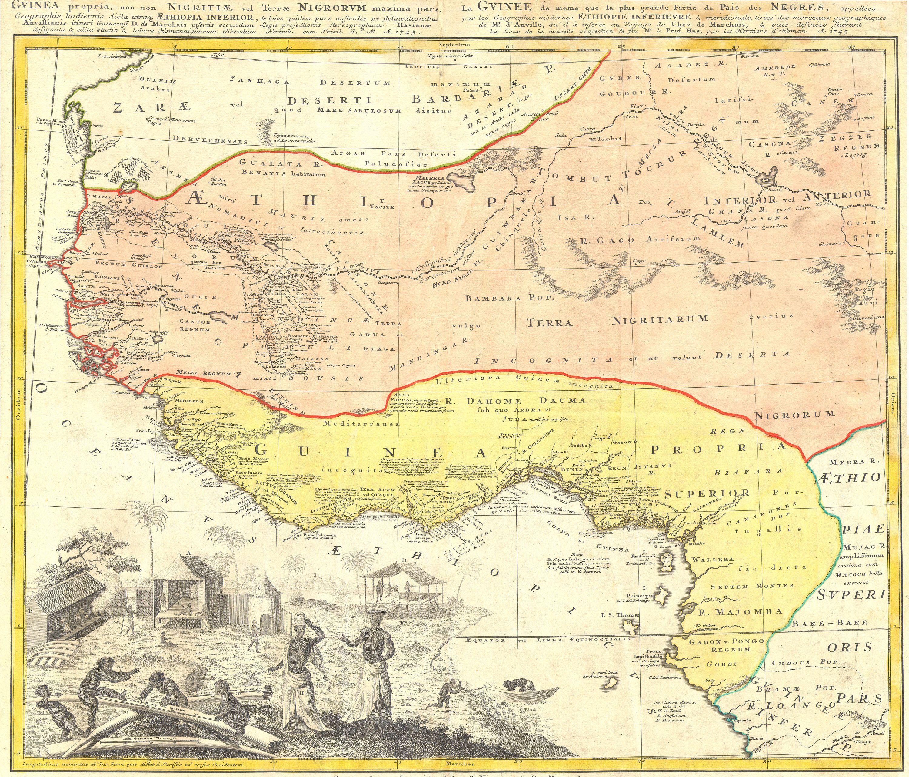
Guinea Propria, Nec Non Nigritiae Vel Terrae Nigorum…Aethiopia Inferior…1743. |
|||||
| Bayani |
English: One of the finest maps of west Africa to appear in the mid 17th century. Details West Africa from Cape Blanc and Senegal to Guinea Inferior and the Cacongo and Barbela Rivers. Extends inland to including Ghana Lake on the Niger River as far as Regio Auri. The coast is highly detailed with numerous notations in Latin regarding the peoples and tribes of the region. The detail extends inland along some river valleys, most specifically the Niger, however, the map becomes quite vague the farther the river flows inland. Features an elaborate engraving in the lower left depicting ivory, Africa tribespeople and a small village. |
|||||
| Rana | 1743 | |||||
| Dimensions | tsawo: 19 in (48.2 cm); faɗi: 23 in (58.4 cm) | |||||
| Accession number |
Geographicus link: Aethiopia-hmhr-1743 |
|||||
| Source/Photographer |
|
|||||
| Izini (Sake amfani da wannan fayil) |
|
|||||
Tarihin fayil
Ku latsa rana/lokaci ku ga fayil yadda yake a wannan lokaci
| Rana/Lokaci | Wadar sufa | Kusurwowi | Ma'aikaci | Bahasi | |
|---|---|---|---|---|---|
| na yanzu | 11:17, 24 ga Maris, 2011 | | 3,000 × 2,562 (1.94 MB) | BotMultichillT | {{subst:User:Multichill/Geographicus |link=http://www.geographicus.com/P/AntiqueMap/Aethiopia-hmhr-1743 |product_name=1743 Homann Heirs Map of West Africa ( Slave Trade references ) "Guinea" |map_title=Guinea Propria, Nec Non Nigritiae Vel Terrae Nigorum� |
Amfani da fayil
Wadannan shafi na amfani wannan fayil:
Amfanin fayil a ko'ina
Wadannan sauran wikis suna amfani da fayil din anan
- Amfani a kan ca.wikipedia.org
- Amfani a kan en.wikipedia.org
- Amfani a kan es.wikipedia.org
- Amfani a kan eu.wikipedia.org
- Amfani a kan fi.wikibooks.org
- Amfani a kan he.wikipedia.org
- Amfani a kan ja.wikipedia.org
- Amfani a kan sw.wikipedia.org
- Amfani a kan tr.wikipedia.org
_%22Guinea%22_-_Geographicus_-_Aethiopia-hmhr-1743.jpg)