
File:Bixby Creek Bridge, California, USA - May 2013.jpg

Yanayin wannan rigayi gani: 800 × 396 pixels. Wasu yarjejeniyoyi: 320 × 159 pixels | 640 × 317 pixels | 1,024 × 507 pixels | 1,280 × 634 pixels | 2,560 × 1,268 pixels | 6,488 × 3,214 pixels.
Hoton asali (pikisal 6,488 × 3,214, girman fayil: 7.84 MB, irin MIME: image/jpeg)
|
Taƙaici
| Bayani |
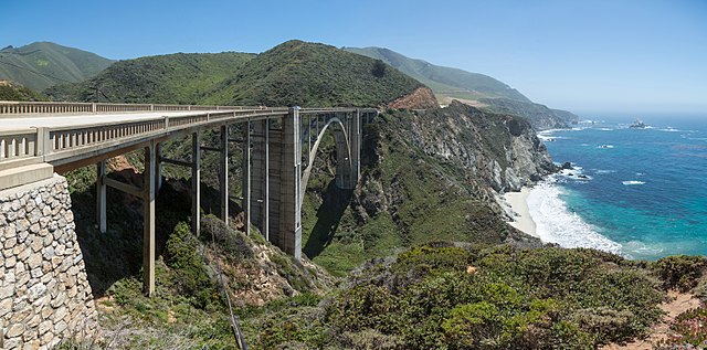
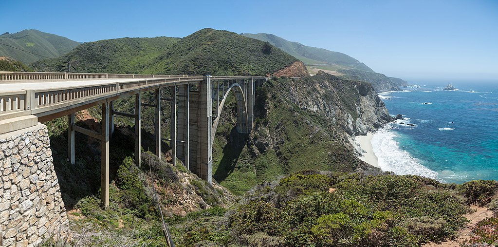
English: Bixby Creek Bridge, viewed from the northern side near Big Sur on the Central Californian Coast in the United States. |
| Rana | |
| Masomi | Aikin na |
| Marubucin | Diliff |
| Izini (Sake amfani da wannan fayil) |
Summary:In using this image or any subsequent derivatives of it, you are required to release the image under the same license. As such, any reproduction of this image, in any medium, must appear with a copy of, or full URL of the license.Attribution of this image to the author (DAVID ILIFF) is also required, preferably in a prominent location near the image.No other conditions may be added to, or removed from this license without the permission of the author and copyright holder.Suggested attribution: "Photo by DAVID ILIFF. License: CC BY-SA 3.0"Please review the full license requirements carefully before using this image. If you would like to clarify the terms of the license or negotiate less restrictive commercial licensing outside of the bounds of GFDL/CC-BY-SA, please contact me by email, or if you don't have a Wikipedia account you can either leave a message on my talk page with your contact details and your request, or you can contact me on Facebook. Please also send a 'friend request' to ensure that I am aware of your message. |
| Other versions |


| Camera location | | View this and other nearby images on: OpenStreetMap |
|---|
Lasisi
I, the copyright holder of this work, hereby publish it under the following licenses:
Wannan fayil ɗin an bada lasisin shi ƙarƙashin Creative Commons Attribution-Share Alike 3.0 Unported lasisi.
- Za ka iya:
- a raba – dan kwafa, yadawa da aika aikin
- dan maimaita – dan daukar aikin
- A karkashin wannan sharuddan
- Jinginarwa – Dole ku bada jinjina da ta dace, samar da linki zuwa lasisin, da kuma bayyana ko kunyi sauyi. Zaku iya haka ta yadda ta dace, amma ba kowace hanya ba wanda zai nuna mai-lasisin yana goyon bayan ku ba ko goyon bayan amfanin da kuke yi ba.
- Yada ahaka – Idan kuka maimaita, sabuntawa, ko kari akan wannan, dole ku bayar da gudunmuwar ku karkashin iri daya ko lasisi data dace kamar na asali.

|
An bada damar a kofa, a yaɗa/ko sauya wannan kundi ƙarƙashin Lasisin GNU ta kyauta, Fitarwa na 1.2 ko duk wani fitarwa da zai biyo baya daga Gidauniyar Samar da Software ta Kyauta; ba tare da sauyin sashe ba, babu Rubutun Fuskar gaban shafi, kuma babu Rubutun bayan shafi. Kofi na lasisin na nan an sanya sa aciki ƙarƙashin sashen GNU Free Documentation License. |
Ku na iya zaɓan lasisin da kuke so.
Tarihin fayil
Ku latsa rana/lokaci ku ga fayil yadda yake a wannan lokaci
| Rana/Lokaci | Wadar sufa | Kusurwowi | Ma'aikaci | Bahasi | |
|---|---|---|---|---|---|
| na yanzu | 09:38, 30 ga Augusta, 2017 | | 6,488 × 3,214 (7.84 MB) | Nikhil B | Reverted to version as of 06:34, 28 May 2013 (UTC) |
| 08:26, 18 ga Yuni, 2017 |  | 1,920 × 951 (770 KB) | Dpalma01 | Color corrected file. | |
| 06:34, 28 Mayu 2013 |  | 6,488 × 3,214 (7.84 MB) | Diliff | {{Information |Description ={{en|1=Bixby Creek Bridge, viewed from the northern side near Big Sur on the Central Californian Coast in the United States.}} |Source ={{own}} |Author =Diliff |Date =2013-05-20 |... |
Amfani da fayil
Wadannan shafi na amfani wannan fayil:
Amfanin fayil a ko'ina
Wadannan sauran wikis suna amfani da fayil din anan
- Amfani a kan de.wikivoyage.org
- Amfani a kan en.wikipedia.org
- California State Route 1
- Wikipedia:WikiProject U.S. Roads/California
- Bixby Bridge
- User:Diliff
- Wikipedia:Featured pictures/Places/Architecture
- Talk:Bixby Bridge
- Portal:Architecture/Travel images
- List of state highways in California
- Wikipedia:WikiProject U.S. Roads/Recognized content
- Wikipedia:WikiProject U.S. Roads/California/Recognized content
- Wikipedia:WikiProject U.S. Roads/Main page content
- Wikipedia:Featured pictures thumbs/39
- User:EuroCarGT/Possible FPC
- Wikipedia:Featured picture candidates/Bixby Creek Bridge
- Wikipedia:Featured picture candidates/February-2014
- User talk:EuroCarGT/Archives/2014/February
- User talk:Diliff/Archive12
- Wikipedia:Picture of the day/December 2015
- Template:POTD/2015-12-26
- User talk:EuroCarGT/Archives/2015/December
- Wikipedia:Main Page history/2015 December 26
- User talk:Diliff/Archive14
- User:Tv's emory/Sandbox/List of state highways in California
- Wikipedia:WikiProject U.S. Roads/State highways
- Wikipedia:WikiProject U.S. Roads/State highways/Recognized content
- Big Sur Coast Highway
- Portal:The arts/Recognized content
- Portal:Architecture/Recognized content
- Amfani a kan fa.wikipedia.org
- ویکیپدیا:نگارههای برگزیده/جاها/معماری
- ویکیپدیا:گزیدن نگاره برگزیده/مقالههای ناموجود/پیشنهادی
- ویکیپدیا:نگاره روز/مارس ۲۰۲۴
- ویکیپدیا:گزیدن نگاره برگزیده/اوت-۲۰۲۳
- بحث کاربر:Behnam mancini/بایگانی ۳
- ویکیپدیا:گزیدن نگاره برگزیده/Bixby Creek Bridge, California, USA - May 2013.jpg
- پل بیکسبی
- الگو:نر/2024-03-30
- الگو:نر محافظت شده/2024-03-30
- Amfani a kan fr.wikipedia.org
- Amfani a kan he.wikipedia.org
- Amfani a kan he.wikivoyage.org
- Amfani a kan it.wikipedia.org
- Amfani a kan ka.wikipedia.org
- Amfani a kan ko.wikipedia.org
- Amfani a kan mg.wikipedia.org
- Amfani a kan pl.wikipedia.org
- Amfani a kan sv.wikipedia.org
Duba ƙarin amfanin wannan fayil.