
File:Borneo fires October 2006.jpg
Yanayin wannan rigayi gani: 800 × 600 pixels. Wasu yarjejeniyoyi: 320 × 240 pixels | 640 × 480 pixels | 1,024 × 768 pixels | 1,280 × 960 pixels | 2,560 × 1,920 pixels | 4,000 × 3,000 pixels.
Hoton asali (pikisal 4,000 × 3,000, girman fayil: 1.94 MB, irin MIME: image/jpeg)
| Bayani |
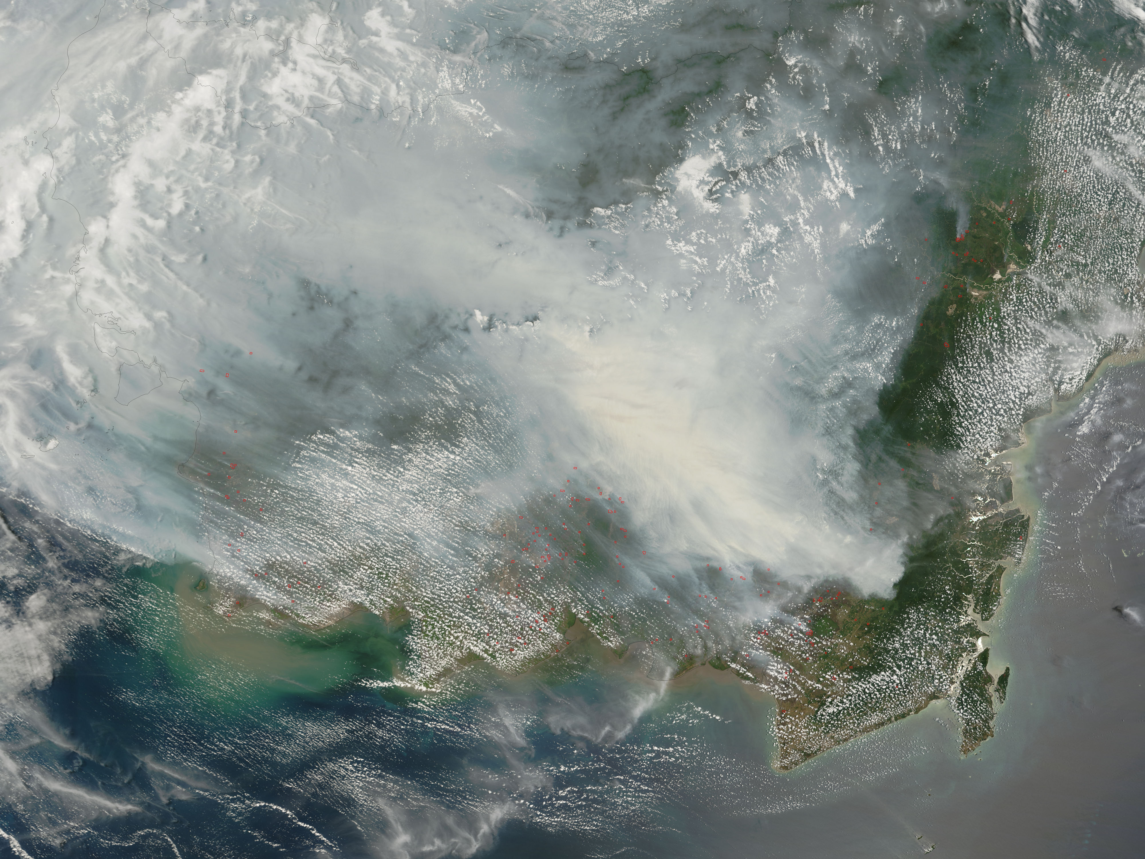
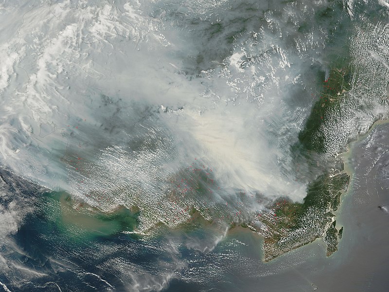
Fires on Borneo Thick smoke hung over the island of Borneo when the Moderate Resolution Imaging Spectroradiometer (MODIS) on NASA’s Terra satellite passed overhead on October 5, 2006. The sensor detected scores of fires (locations marked in red) in the Kalimantan province of Indonesia, and smoke billowed northward over the Malaysian part of the island, as well. The fires occur annually in the dry season (August-October), caused mainly by land-clearing and other agricultural fires. Fires escape control and burn into forests and peat-swamp areas. Fires in peat—thick layers of dead, but un-decayed vegetation—are extremely smoky and difficult to put out. Some of the blazes will only be extinguished when the monsoon rains start in upcoming weeks. |
|||||
| Rana | ||||||
| Masomi | http://earthobservatory.nasa.gov/NaturalHazards/natural_hazards_v2.php3?img_id=13916 | |||||
| Marubucin | NASA image by Jeff Schmaltz, MODIS Rapid Response Team. | |||||
| Izini (Sake amfani da wannan fayil) |
|

العربية: دخان كثيف بعد حريق ضخم في جزيرة بورنيو عام 2006م في مقاطعة كاليمانتان في اندونيسيا.
Tarihin fayil
Ku latsa rana/lokaci ku ga fayil yadda yake a wannan lokaci
| Rana/Lokaci | Wadar sufa | Kusurwowi | Ma'aikaci | Bahasi | |
|---|---|---|---|---|---|
| na yanzu | 09:30, 9 Oktoba 2006 | | 4,000 × 3,000 (1.94 MB) | NSLE-Chacor | {{Information |Description= Fires on Borneo Thick smoke hung over the island of Borneo when the Moderate Resolution Imaging Spectroradiometer (MODIS) on NASA’s Terra satellite passed overhead on October 5, 2006. The sensor detected scores of fires (loc |
Amfani da fayil
Wadannan 2 shafuka suna amfani wannan fayil:
Amfanin fayil a ko'ina
Wadannan sauran wikis suna amfani da fayil din anan
- Amfani a kan ar.wikipedia.org
- Amfani a kan as.wikipedia.org
- Amfani a kan ba.wikipedia.org
- Amfani a kan bn.wikipedia.org
- Amfani a kan de.wikipedia.org
- Amfani a kan en.wikipedia.org
- ASEAN
- Illegal logging
- ASEAN Agreement on Transboundary Haze Pollution
- Peat swamp forest
- Borneo peat swamp forests
- 2006 Southeast Asian haze
- Mega Rice Project
- Deforestation in Indonesia
- User:Montyhasan/sandbox
- User:Mentoroso/sandbox2
- User:Lyons34/sandbox
- User:Monruw/sandbox
- Wikipedia:In the news/Posted/October 2006
- Amfani a kan en.wikinews.org
- Amfani a kan es.wikipedia.org
- Amfani a kan fa.wikipedia.org
- Amfani a kan hr.wikipedia.org
- Amfani a kan id.wikipedia.org
- Amfani a kan ig.wikipedia.org
- Amfani a kan it.wikipedia.org
- Amfani a kan mn.wikipedia.org
- Amfani a kan ms.wikipedia.org
- Amfani a kan ru.wikipedia.org
- Amfani a kan sh.wikipedia.org
- Amfani a kan sr.wikipedia.org
- Amfani a kan th.wikipedia.org
- Amfani a kan uk.wikipedia.org
- Amfani a kan ur.wikipedia.org
- Amfani a kan uz.wikipedia.org
- Amfani a kan vi.wikipedia.org
- Amfani a kan zh.wikipedia.org
Duba ƙarin amfanin wannan fayil.