
File:CO2 responsibility 1950-2000.svg

Hoton asali (Fayil kin SVG, saƙar fikisal 940 x 477, girman fayil: 1.98 MB)
Taƙaici
| Bayani |
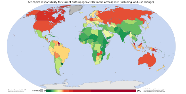
English: Cumulative per capita responsibility for anthropogenic CO2
Data from the World Resources Institute's CAIT 4.0 database (registration required). Includes CO2 emitted up to the year 2000 only (not CH4, N20, PFCs, HFCs or SF6). Estimates of the effects of land-use change are included; bunker-fuel emissions are not. The scale is a 0-100 decay-weighted index. The land-use estimates include the following (list from the relevant CAIT data note):
those of the original ecosystem
of forests in many tropical regions)
estimates include the emissions of carbon from wood products (burned, stored in longterm pools, decayed over time)
Also from the CAIT data note: "It is also important to note that the calculated flux of carbon does not explicitly include changes in carbon stocks that may result from various forms of management. Examples of what is not included are agricultural intensification, fertilization, the trend to no-till agriculture, thinning of forests, changes in species or varieties, and other silvicultural practices." And the data note warns that "these estimates of national sources and sinks of carbon from land-use change are uncertain on the order of +/- 150% for large fluxes, and +/- 50 MtC/yr for estimates near zero." So CAIT's land-use estimates are a bit wild. They are, however, the best currently available at a national level. |
| Rana | 05/9/07 |
| Masomi | self-made using data from the World Resources Institute and a blank map by Canuckguy and others |
| Marubucin | Vinny Burgoo |
Lasisi

|
An bada damar a kofa, a yaɗa/ko sauya wannan kundi ƙarƙashin Lasisin GNU ta kyauta, Fitarwa na 1.2 ko duk wani fitarwa da zai biyo baya daga Gidauniyar Samar da Software ta Kyauta; ba tare da sauyin sashe ba, babu Rubutun Fuskar gaban shafi, kuma babu Rubutun bayan shafi. Kofi na lasisin na nan an sanya sa aciki ƙarƙashin sashen GNU Free Documentation License. |
| Wannan fayil ɗin an bada lasisin shi ƙarƙashin Creative Commons Attribution-Share Alike 3.0 Unported lasisi. | ||
| ||
| This licensing tag was added to this file as part of the GFDL licensing update. |
Tarihin fayil
Ku latsa rana/lokaci ku ga fayil yadda yake a wannan lokaci
| Rana/Lokaci | Wadar sufa | Kusurwowi | Ma'aikaci | Bahasi | |
|---|---|---|---|---|---|
| na yanzu | 23:22, 4 Satumba 2007 | | 940 × 477 (1.98 MB) | Vinny Burgoo | {{Information |Description='''Cumulative per capita responsibility for anthropogenic CO2''' Data from the World Resources Institute's [http://cait.wri.org/ CAIT 4.0 database] (registration required). Includes CO2 only (not CH4, N20, PFCs, HFCs or SF6). E |
Amfani da fayil
Wadannan shafi na amfani wannan fayil:
Amfanin fayil a ko'ina
Wadannan sauran wikis suna amfani da fayil din anan
- Amfani a kan ar.wikipedia.org
- Amfani a kan bn.wikipedia.org
- Amfani a kan bs.wikipedia.org
- Amfani a kan ca.wikipedia.org
- Amfani a kan cs.wikipedia.org
- Amfani a kan da.wikipedia.org
- Amfani a kan de.wikipedia.org
- Amfani a kan en.wikipedia.org
- Amfani a kan et.wikipedia.org
- Amfani a kan eu.wikipedia.org
- Amfani a kan fa.wikipedia.org
- Amfani a kan fr.wikipedia.org
- Amfani a kan gu.wikipedia.org
- Amfani a kan he.wikipedia.org
- Amfani a kan hi.wikipedia.org
- Amfani a kan hy.wikipedia.org
- Amfani a kan mk.wikipedia.org
- Amfani a kan pnb.wikipedia.org
- Amfani a kan pt.wikipedia.org
- Amfani a kan ru.wikipedia.org
- Amfani a kan so.wikipedia.org
- Amfani a kan ta.wikipedia.org
- Amfani a kan th.wikipedia.org
- Amfani a kan uk.wikipedia.org
- Amfani a kan ur.wikipedia.org
- Amfani a kan vi.wikipedia.org
- Amfani a kan zh.wikipedia.org