
File:Dahomey-Niger boundary. LOC 84692244.jpg

Yanayin wannan rigayi gani: 452 × 599 pixels. Wasu yarjejeniyoyi: 181 × 240 pixels | 362 × 480 pixels | 580 × 768 pixels | 773 × 1,024 pixels | 1,546 × 2,048 pixels | 3,133 × 4,150 pixels.
Hoton asali (pikisal 3,133 × 4,150, girman fayil: 1.06 MB, irin MIME: image/jpeg)
Taƙaici
| Bayani |
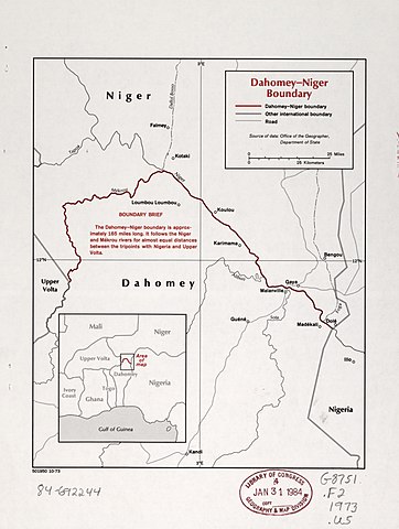
English: "501950 10-73." "Source of data: Office of the Geographer, Department of State." Includes note and key map. Available also through the Library of Congress Web site as a raster image. |
||
| Title | Dahomey-Niger boundary. | ||
| Shelf ID | G8751.F2 1973 .U5 | ||
| Rana | |||
| Masomi | https://www.loc.gov/item/84692244/ | ||
| Marubucin | United States. Central Intelligence Agency; United States. Department Of State. Office Of The Geographer | ||
| Izini (Sake amfani da wannan fayil) |
|
||
| Other versions |
|
||
| Location | Niger · Benin | ||
| Part of | American Memory · General Maps · Catalog · Geography And Map Division | ||
| Subject | Boundaries · Maps · Niger · Benin |


Lasisi
| This image is a work of a Central Intelligence Agency employee, taken or made as part of that person's official duties. As a Work of the United States Government, this image or media is in the public domain in the United States.
|

|
Tarihin fayil
Ku latsa rana/lokaci ku ga fayil yadda yake a wannan lokaci
| Rana/Lokaci | Wadar sufa | Kusurwowi | Ma'aikaci | Bahasi | |
|---|---|---|---|---|---|
| na yanzu | 00:16, 17 Satumba 2018 | | 3,133 × 4,150 (1.06 MB) | Fæ | LOC Maps https://www.loc.gov/item/84692244/ #29429 |
Amfani da fayil
Wadannan shafi na amfani wannan fayil:
Amfanin fayil a ko'ina
Wadannan sauran wikis suna amfani da fayil din anan
- Amfani a kan cs.wikipedia.org
- Amfani a kan de.wikipedia.org
- Amfani a kan en.wikipedia.org