
Fayil:Eyjafjallajökull.jpeg

Yanayin wannan rigayi gani: 800 × 536 pixels. Wasu yarjejeniyoyi: 320 × 214 pixels | 640 × 429 pixels | 1,024 × 686 pixels | 1,280 × 858 pixels | 2,960 × 1,983 pixels.
Hoton asali (pikisal 2,960 × 1,983, girman fayil: 3.96 MB, irin MIME: image/jpeg)
| Bayani |
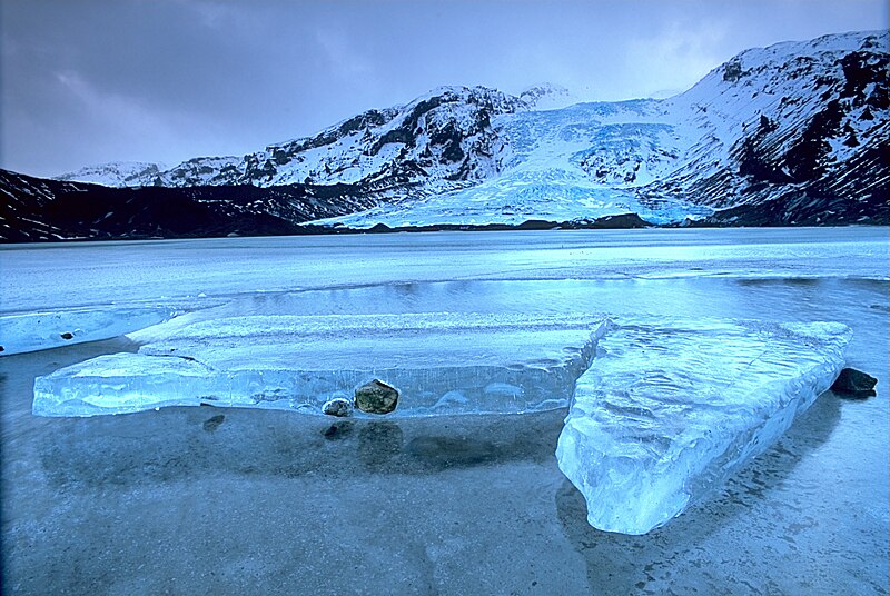
English: Gígjökull, an outlet glacier extending from Eyjafjallajökull, Iceland. Lónið is the lake visible in the foreground.
Tiếng Việt: Sông băng Eyjafjallajökull tại Iceland.
Photo was taken using the following technique:
|
||
| Rana | 2003-02-13, 11:00–12:00 | ||
| Masomi |
Aikin na: http://fam-tille.de/sparetime.html |
||
| Marubucin | Andreas Tille | ||
| Izini (Sake amfani da wannan fayil) |
Quote of http://fam-tille.de/island/winter/0213/2003_093.html - Permission is granted to copy, distribute and/or modify this images under the terms of the GNU Free Documentation License, Version 1.1 or any later version published by the Free Software Foundation. I, the copyright holder of this work, hereby publish it under the following licenses:
This file is licensed under the Creative Commons Attribution-Share Alike 3.0 Unported, 2.5 Generic, 2.0 Generic and 1.0 Generic license.
Ku na iya zaɓan lasisin da kuke so. |

| Camera location | | View this and other nearby images on: OpenStreetMap |
|---|
| Annotations | This image is annotated: View the annotations at Commons |
Assessment
|
This image was selected as picture of the day on Wikimedia Commons for 21 December 2004. It was captioned as follows: Other languages:
Esperanto: Glaciejo Eyjafjallajökull en Islando |
This image was selected as picture of the day on Vietnamese Wikipedia.
|
Tarihin fayil
Ku latsa rana/lokaci ku ga fayil yadda yake a wannan lokaci
| Rana/Lokaci | Wadar sufa | Kusurwowi | Ma'aikaci | Bahasi | |
|---|---|---|---|---|---|
| na yanzu | 12:01, 2 Disamba 2004 | | 2,960 × 1,983 (3.96 MB) | Ævar Arnfjörð Bjarmason |
Amfani da fayil
Babu shafuka da suke amfani da fayil din nan.
Amfanin fayil a ko'ina
Wadannan sauran wikis suna amfani da fayil din anan
- Amfani a kan af.wikipedia.org
- Amfani a kan an.wikipedia.org
- Amfani a kan arc.wikipedia.org
- Amfani a kan ar.wikipedia.org
- Amfani a kan arz.wikipedia.org
- Amfani a kan azb.wikipedia.org
- Amfani a kan be.wikipedia.org
- Amfani a kan bg.wikipedia.org
- Amfani a kan bg.wikinews.org
- Amfani a kan bo.wikipedia.org
- Amfani a kan br.wikipedia.org
- Amfani a kan bs.wikipedia.org
- Amfani a kan ca.wikipedia.org
- Amfani a kan co.wikipedia.org
- Amfani a kan cs.wikipedia.org
- Amfani a kan da.wikipedia.org
- Amfani a kan de.wikipedia.org
- Eisscholle
- Benutzer:Rainbowfish/Test10
- Wikipedia:Kandidaten für exzellente Bilder/Archiv2005/7
- Wikipedia:Archiv/Hilfe:MediaWiki/Versionen
- Benutzer:Torinberl/Testterrain
- Benutzer:Torinberl/Benutzerseite
- Portal Diskussion:Island/Bild des Monats
- Benutzer Diskussion:Placebo111
- Portal Diskussion:Island/Bild des Monats/Archiv/2006
- Benutzer:Rainbowfish/Bilder
- Benutzer:Rainbowfish/ALT
- Portal Diskussion:Vulkane/Vulkanbild der Woche
- Amfani a kan de.wiktionary.org
- Amfani a kan dsb.wikipedia.org
- Amfani a kan el.wikipedia.org
- Amfani a kan en.wikipedia.org
Duba ƙarin amfanin wannan fayil.