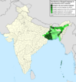
Fayil:Geographic distribution of Bengali language.png

Page contents not supported in other languages.
Daga Wikipedia, Insakulofidiya ta kyauta.

Hoton asali(pikisal 2,806 × 2,080, girman fayil: 1.36 MB, irin MIME: image/png)

Wannan hoto yazo daga Wikimedia Commons kuma za'a iya amfani dashi a wasu projects. Anan kasa an nuna asalin bayanin shi

Taƙaici

Bayani
Ελληνικά: Γεωγραφική κατανομή της Βεγγαλικής Γλώσσας ανά επαρχία της Ινδίας και στο Μπανγκλαντές, τα χρώματα στις επαρχίες ποικίλουν ανάλογα με το ποσοστό ομιλητών (δεδομένα απογραφής 2011). Παράγωγο του αρχείου India district map (de-facto).svg.
English: Geographic distribution of Bengali language in India and Bangladesh. The map covers each district of India and the five shades of green show the percentage of Bengali language speakers in each district. Source: Indian census 2011. Feel free to enrich the map with data for more Indian districts, or fix any mistakes. Derivative of the file India district map (de-facto).svg.
Rana
Masomi Aikin na
Marubucin NikosLikomitros

Lasisi

I, the copyright holder of this work, hereby publish it under the following license:
w:en:Creative Commons
Jinginarwa Yada ahaka
This file is licensed under the Creative Commons Attribution-Share Alike 4.0 International license.
Za ka iya:
  • a raba – dan kwafa, yadawa da aika aikin
  • dan maimaita – dan daukar aikin
A karkashin wannan sharuddan
  • Jinginarwa – Dole ku bada jinjina da ta dace, samar da linki zuwa lasisin, da kuma bayyana ko kunyi sauyi. Zaku iya haka ta yadda ta dace, amma ba kowace hanya ba wanda zai nuna mai-lasisin yana goyon bayan ku ba ko goyon bayan amfanin da kuke yi ba.
  • Yada ahaka – Idan kuka maimaita, sabuntawa, ko kari akan wannan, dole ku bayar da gudunmuwar ku karkashin iri daya ko lasisi data dace kamar na asali.

Take

Add a one-line explanation of what this file represents
Geographic distribution of Bengali language in India and Bangladesh. The map covers each district of India and the five shades of green show the percentage of Bengali language speakers in each district. Source: Indian census 2011.

Abubuwan da aka nuna a cikin wannan fayil

depicts Turanci

Wasu muhimman ba tare da Wikidata kayayyaki ba

copyrighted Turanci

26 Yuni 2022

media type Turanci

image/png

Tarihin fayil

Ku latsa rana/lokaci ku ga fayil yadda yake a wannan lokaci

Rana/LokaciWadar sufaKusurwowiMa'aikaciBahasi
na yanzu15:05, 2 ga Yuli, 2022Wadar sufa ta zubin 15:05, 2 ga Yuli, 20222,806 × 2,080 (1.36 MB)NikosLikomitrosA few districts of Arunachal Pradesh have a notable Bengali presence above of 1%, probably part of the Indian efforts to increase its presence in the region.
16:55, 1 ga Yuli, 2022Wadar sufa ta zubin 16:55, 1 ga Yuli, 20222,806 × 2,080 (1.36 MB)NikosLikomitrosTwo extra fixes.
16:53, 1 ga Yuli, 2022Wadar sufa ta zubin 16:53, 1 ga Yuli, 20222,806 × 2,080 (1.36 MB)NikosLikomitrosMinor fixes.
16:44, 1 ga Yuli, 2022Wadar sufa ta zubin 16:44, 1 ga Yuli, 20222,806 × 2,080 (1.36 MB)NikosLikomitrosNow, this map covers all districts of India. Includes also extra information and a new colour key. The basemap is from Distribution_of_Jats_in_South_Asia.png.
21:09, 26 ga Yuni, 2022Wadar sufa ta zubin 21:09, 26 ga Yuni, 20221,902 × 2,048 (1,002 KB)NikosLikomitrosUploaded own work with UploadWizard

Babu shafuka da suke amfani da fayil din nan.

Amfanin fayil a ko'ina

Wadannan sauran wikis suna amfani da fayil din anan

bayannan meta