
File:Guillaume Delisle Senegambia 1707.jpg
Yanayin wannan rigayi gani: 800 × 482 pixels. Wasu yarjejeniyoyi: 320 × 193 pixels | 640 × 385 pixels | 1,024 × 617 pixels | 1,280 × 771 pixels | 2,200 × 1,325 pixels.
Hoton asali (pikisal 2,200 × 1,325, girman fayil: 784 KB, irin MIME: image/jpeg)
Taƙaici
| Bayani |
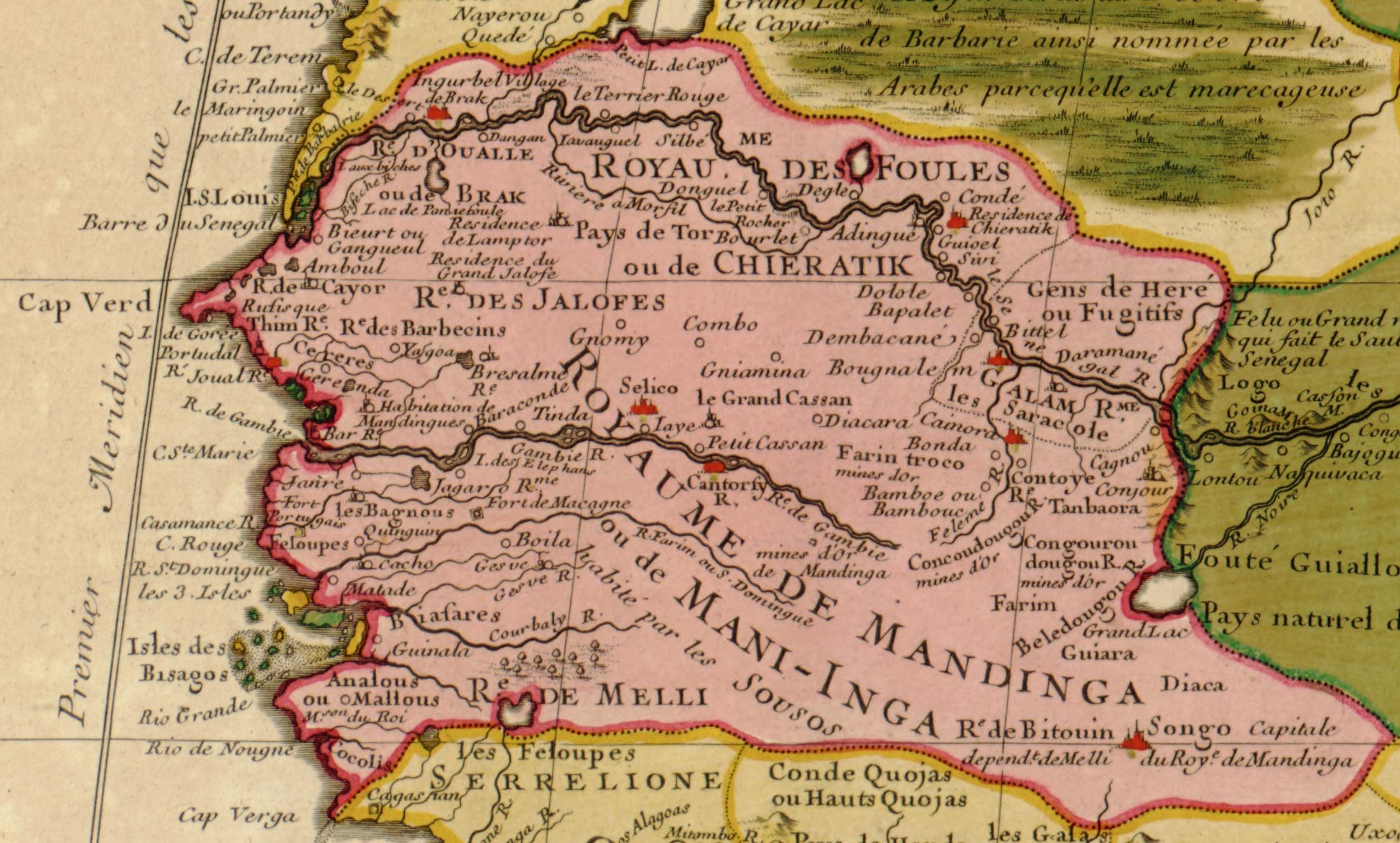
English: Part of North West Africa (original title: Carte de la Barbarie de la Nigritie et de La Guinee; it translates: "Map of the Barbary of Nigritie & Guinea") |
|||||||||||||||||||||||
| Rana | C.E.1707/H.E.11,707 | |||||||||||||||||||||||
| Masomi |
Library of Congress Geography & Map Division; Call Number G8220 1707 .L5
|
|||||||||||||||||||||||
| Marubucin |
|
|||||||||||||||||||||||
| Other versions | full map: File:Guillaume_Delisle_North_West_Africa_1707.jpg | |||||||||||||||||||||||


Lasisi
|
This work is in the public domain in its country of origin and other countries and areas where the copyright term is the author's life plus 100 years or fewer. | |
| This file has been identified as being free of known restrictions under copyright law, including all related and neighboring rights. | |
Tarihin fayil
Ku latsa rana/lokaci ku ga fayil yadda yake a wannan lokaci
| Rana/Lokaci | Wadar sufa | Kusurwowi | Ma'aikaci | Bahasi | |
|---|---|---|---|---|---|
| na yanzu | 12:42, 3 ga Yuni, 2006 | | 2,200 × 1,325 (784 KB) | Ephraim33 | {{Information| |Description=Part of North West Africa (original title: Carte de la Barbarie de la Nigritie et de La Guinee) |Source=http://memory.loc.gov/cgi-bin/map_item.pl?data=/home/www/data/gmd/gmd8/g8220/g8220/ct001447.jp2&itemLink=D?gmd:12:./temp/~a |
Amfani da fayil
Wadannan shafi na amfani wannan fayil:
Amfanin fayil a ko'ina
Wadannan sauran wikis suna amfani da fayil din anan
- Amfani a kan af.wikipedia.org
- Amfani a kan als.wikipedia.org
- Amfani a kan an.wikipedia.org
- Amfani a kan ar.wikipedia.org
- Amfani a kan ast.wikipedia.org
- Amfani a kan be.wikipedia.org
- Amfani a kan ca.wikipedia.org
- Amfani a kan de.wikipedia.org
- Amfani a kan en.wikipedia.org
- Amfani a kan es.wikipedia.org
- Amfani a kan eu.wikipedia.org
- Amfani a kan fi.wikipedia.org
- Amfani a kan frr.wikipedia.org
- Amfani a kan fr.wikipedia.org
- Amfani a kan gl.wikipedia.org
- Amfani a kan io.wikipedia.org
- Amfani a kan it.wikipedia.org
- Amfani a kan ja.wikipedia.org
- Amfani a kan ka.wikipedia.org
Duba ƙarin amfanin wannan fayil.