
File:Jerusalem-2013(2)-Temple Mount-Dome of the Chain (south exposure).jpg
Yanayin wannan rigayi gani: 676 × 600 pixels. Wasu yarjejeniyoyi: 271 × 240 pixels | 541 × 480 pixels | 866 × 768 pixels | 1,154 × 1,024 pixels | 2,308 × 2,048 pixels | 6,500 × 5,767 pixels.
Hoton asali (pikisal 6,500 × 5,767, girman fayil: 21.64 MB, irin MIME: image/jpeg)
Taƙaici
| Bayani |
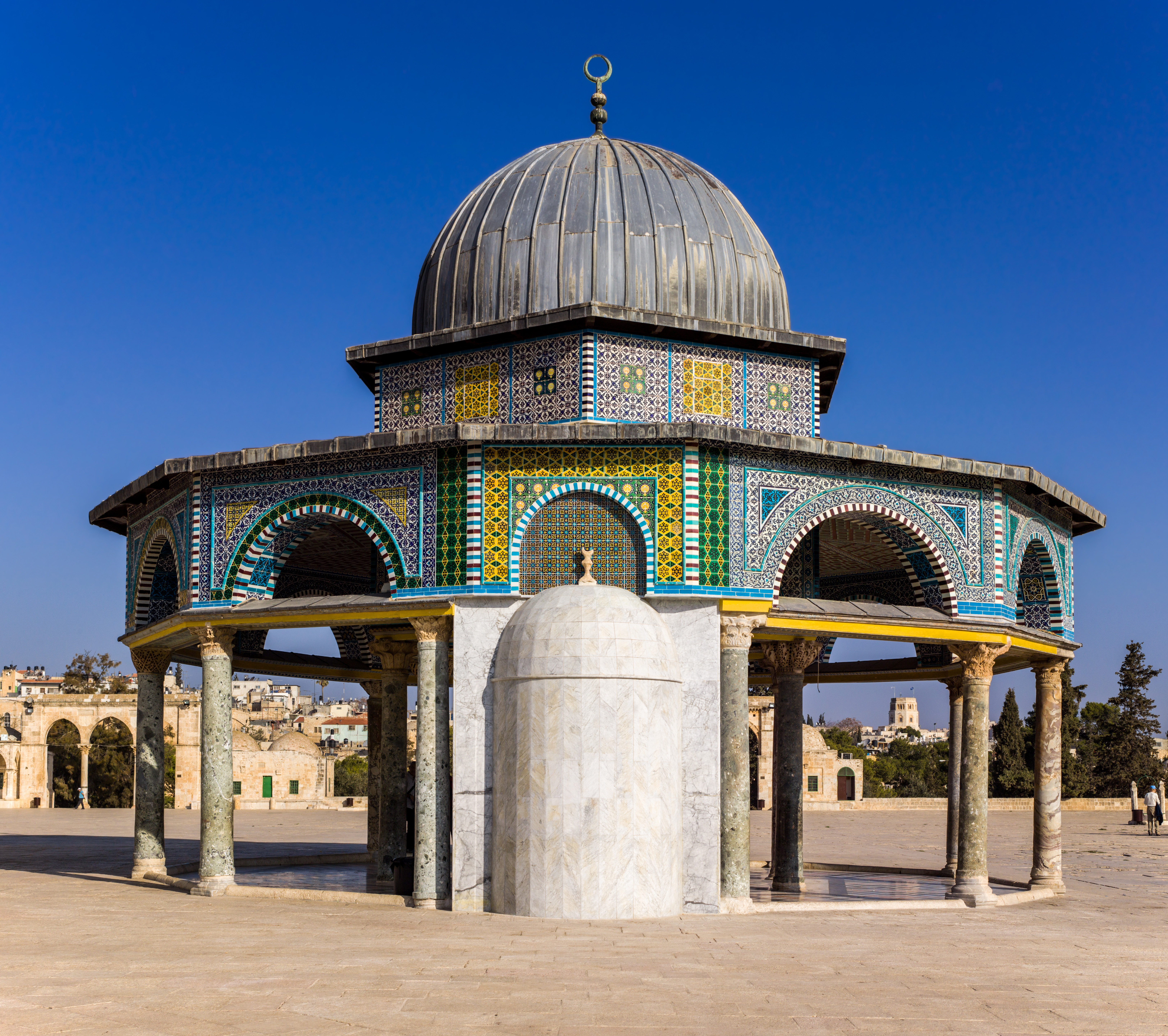
العربية: قِبَّةُ السِّلسلة فيالحرم القدسي الشريف داخل بلدة القدس القديمة. أُنشأت قبَّة السلسلة خلال العهد الأُمويّ (حوالي سنة 685 ميلاديَّة) واتُّخذت نموذجًا لإنشاء مسجد قبَّة الصخرة (حوالي سنة 691 ميلاديَّة).
English: The Dome of the Chain (Arabic: قبة السلسلة, Qubbat al-Silsila), on the Temple Mount in the Old City of Jerusalem. The Dome of the Chain was constructed during the Umayyad Caliphate (c. 685 AD) and served as a model for the building of The Dome of the Rock (Arabic: مسجد قبة الصخرة, Hebrew: כיפת הסלע) (c. 691 AD). |
| Rana | |
| Masomi | Aikin na |
| Marubucin | Godot13 |
| Jinginarwa (required by the license) | Andrew Shiva / Wikipedia / |
| Camera location | | View this and other nearby images on: OpenStreetMap |
|---|
Assessment
|

-Temple_Mount-Dome_of_the_Chain_(south_exposure).jpg)
-Temple_Mount-Dome_of_the_Chain_(south_exposure).jpg¶ms=031.777850_N_0035.235808_E_globe:Earth_type:camera_heading:0.00&language=ha)
-Jerusalem-Temple_Mount-Dome_of_the_Chain_(south_exposure).jpg)
-Jerusalem-Temple_Mount-Dome_of_the_Chain_(south_exposure).jpg)
-Temple_Mount-Dome_of_the_Chain_(south_exposure).jpg)
This image was selected as picture of the day on Wikimedia Commons for 1 July 2014. It was captioned as follows: English: The Dome of the Chain (Arabic: قبة السلسلة, Qubbat al-Silsila), on the Temple Mount in the Old City of Jerusalem. Other languages:
Bosanski: The Kupola na lancima (arapski: قبة السلسلة, Kubat el-Silsila), na Brdu Hrama u starom gradu Jerusalema. Čeština: Řetězový dóm (arabsky: قبة السلسلة, Kubbat as-silsila) na Chrámové hoře v Jeruzalémském Starém Městě. English: The Dome of the Chain (Arabic: قبة السلسلة, Qubbat al-Silsila), on the Temple Mount in the Old City of Jerusalem. Français : Le Dôme de la Chaîne, (Arabe: قبة السلسلة, Qubbat al-Silsila), sur le Mont du Temple, dans la Vieille ville de Jérusalem. Italiano: La cupola della catena (arabo: قبة السلسلة, Qubbat al-Silsila) sul Monte del Tempio nella Città Vecchia di Gerusalemme. Magyar: A Lánc mecset a jeruzsálemi Templom-hegyen Polski: Kopuła Łańcucha (ar.: قبة السلسلة, Qubbat al-Silsila) na Wzgórzu Świątynnym na Starym Mieście Jerozolimy. |
Lasisi
I, the copyright holder of this work, hereby publish it under the following license:
This file is licensed under the Creative Commons Attribution-Share Alike 4.0 International license.
- Za ka iya:
- a raba – dan kwafa, yadawa da aika aikin
- dan maimaita – dan daukar aikin
- A karkashin wannan sharuddan
- Jinginarwa – Dole ku bada jinjina da ta dace, samar da linki zuwa lasisin, da kuma bayyana ko kunyi sauyi. Zaku iya haka ta yadda ta dace, amma ba kowace hanya ba wanda zai nuna mai-lasisin yana goyon bayan ku ba ko goyon bayan amfanin da kuke yi ba.
- Yada ahaka – Idan kuka maimaita, sabuntawa, ko kari akan wannan, dole ku bayar da gudunmuwar ku karkashin iri daya ko lasisi data dace kamar na asali.

|
The copyright holder of this file, Andrew Shiva, allows anyone to use it for any purpose, provided that the copyright holder is properly attributed. Redistribution, derivative work, commercial use, and all other use is permitted. |
Jinginarwa:
Use or reproduction of this image outside of Wikipedia must give the original photographer (Andrew Shiva) credit. Although not required, it would be appreciated if a message was left here indicating where this image was being used.
|
| Annotations | This image is annotated: View the annotations at Commons |
-Jerusalem-Temple_Mount-Dome_of_the_Chain-Mihrab.jpg)
-Jerusalem-Temple_Mount-Dome_of_the_Chain-dome_interior.jpg)
Tarihin fayil
Ku latsa rana/lokaci ku ga fayil yadda yake a wannan lokaci
| Rana/Lokaci | Wadar sufa | Kusurwowi | Ma'aikaci | Bahasi | |
|---|---|---|---|---|---|
| na yanzu | 19:31, 15 Disamba 2013 | | 6,500 × 5,767 (21.64 MB) | Godot13 | Spots removed, sky smoothed, CA removed. |
| 00:37, 10 Disamba 2013 |  | 6,500 × 5,767 (23.11 MB) | Godot13 | Very slight lightening (corners) | |
| 03:40, 9 Disamba 2013 |  | 6,500 × 5,767 (18.11 MB) | Godot13 | NR in sky/smoothing | |
| 23:34, 8 Disamba 2013 |  | 6,500 × 5,767 (22.76 MB) | Godot13 | User created page with UploadWizard |
Amfani da fayil
Wadannan shafi na amfani wannan fayil:
Amfanin fayil a ko'ina
Wadannan sauran wikis suna amfani da fayil din anan
- Amfani a kan ar.wikipedia.org
- بوابة:الإسلام/صورة مختارة
- بوابة:فلسطين/صورة مختارة/أرشيف
- ويكيبيديا:ترشيحات الصور المختارة/قبة السلسلة
- قبة السلسلة
- بوابة:فلسطين/صورة مختارة/28
- ويكيبيديا:صور مختارة/أماكن/عمارة
- بوابة:عمارة/صورة مختارة/24
- بوابة:عمارة/صور مساجد
- بوابة:عمارة/صورة مختارة
- ويكيبيديا:صورة اليوم المختارة/فبراير 2015
- قالب:صورة اليوم المختارة/2015-02-28
- ويكيبيديا:صورة اليوم المختارة/أبريل 2016
- قالب:صورة اليوم المختارة/2016-04-07
- بوابة:الإسلام/صورة مختارة/54
- ويكيبيديا:صورة اليوم المختارة/يونيو 2017
- قالب:صورة اليوم المختارة/2017-06-18
- ويكيبيديا:صورة اليوم المختارة/مارس 2018
- قالب:صورة اليوم المختارة/2018-03-05
- ويكيبيديا:صورة اليوم المختارة/مايو 2019
- قالب:صورة اليوم المختارة/2019-05-27
- قبة (عمارة إسلامية)
- ويكيبيديا:صورة اليوم المختارة/أبريل 2021
- قالب:صورة اليوم المختارة/2021-04-05
- Amfani a kan be-tarask.wikipedia.org
- Amfani a kan be.wikipedia.org
- Amfani a kan bn.wikipedia.org
- Amfani a kan ce.wikipedia.org
- Кеп:Таханлера сурт/2014-07
- Кеп:Таханлера сурт/2014-08
- Кеп:Таханлера сурт/2014-10
- Кеп:Таханлера сурт/2014-12
- Кеп:Таханлера сурт/2015-01
- Кеп:Таханлера сурт/2015-03
- Кеп:Таханлера сурт/2015-05
- Кеп:Таханлера сурт/2015-07
- Кеп:Таханлера сурт/2015-08
- Кеп:Таханлера сурт/2015-10
- Кеп:Таханлера сурт/2015-12
- Кеп:Таханлера сурт/2016-01
- Кеп:Таханлера сурт/2016-03
- Кеп:Таханлера сурт/2016-05
- Кеп:Таханлера сурт/2016-07
- Кеп:Таханлера сурт/2016-08
- Кеп:Таханлера сурт/2016-10
- Кеп:Таханлера сурт/2016-12
- Кеп:Таханлера сурт/2017-01
- Кеп:Таханлера сурт/2017-03
- Кеп:Таханлера сурт/2017-05
- Кеп:Таханлера сурт/2017-07
- Кеп:Таханлера сурт/2017-08
Duba ƙarin amfanin wannan fayil.
-Temple_Mount-Dome_of_the_Chain_(south_exposure).jpg)
-Temple_Mount-Dome_of_the_Chain_(south_exposure).jpg)