
File:Lunda Empire.png

Yanayin wannan rigayi gani: 487 × 599 pixels. Wasu yarjejeniyoyi: 195 × 240 pixels | 578 × 711 pixels.
Hoton asali (pikisal 578 × 711, girman fayil: 115 KB, irin MIME: image/png)
Taƙaici
| Bayani |
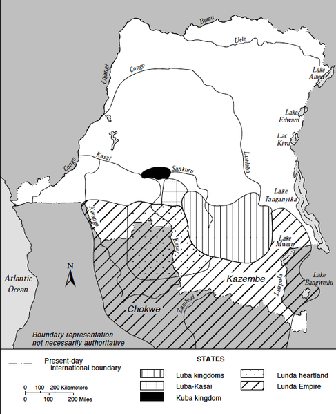
English: Map of Major States in the Southern Savannas, Mid-Nineteenth Century. Based on information from Jan Vansina, Kingdoms of the Savanna, Madison, 1968. The map includes the Lunda Empire (with the Lunda heartland), the Luba kingdoms, the Luba-Kasai and the Kuba kingdom as they were thought to have been around 1850. Ελληνικά: Χάρτης της Αυτοκρατορίας Λούντα |
| Rana | |
| Masomi | Zaire : a country study (1994) |
| Marubucin | Library of Congress |
| Other versions |
|

Lasisi
This work is in the public domain in the United States because it is a work prepared by an officer or employee of the United States Government as part of that person’s official duties under the terms of Title 17, Chapter 1, Section 105 of the US Code.
Note: This only applies to original works of the Federal Government and not to the work of any individual U.S. state, territory, commonwealth, county, municipality, or any other subdivision. This template also does not apply to postage stamp designs published by the United States Postal Service since 1978. (See § 313.6(C)(1) of Compendium of U.S. Copyright Office Practices). It also does not apply to certain US coins; see The US Mint Terms of Use.
|
 | |
| This file has been identified as being free of known restrictions under copyright law, including all related and neighboring rights. | ||
Tarihin fayil
Ku latsa rana/lokaci ku ga fayil yadda yake a wannan lokaci
| Rana/Lokaci | Wadar sufa | Kusurwowi | Ma'aikaci | Bahasi | |
|---|---|---|---|---|---|
| na yanzu | 13:27, 13 ga Janairu, 2015 | | 578 × 711 (115 KB) | Monopoly31121993 | User created page with UploadWizard |
Amfani da fayil
Wadannan shafi na amfani wannan fayil:
Amfanin fayil a ko'ina
Wadannan sauran wikis suna amfani da fayil din anan
- Amfani a kan ast.wikipedia.org
- Amfani a kan ca.wikipedia.org
- Amfani a kan de.wikipedia.org
- Amfani a kan en.wikipedia.org
- Amfani a kan es.wikipedia.org
- Amfani a kan fa.wikipedia.org
- Amfani a kan fi.wikipedia.org
- Amfani a kan fr.wikipedia.org
- Amfani a kan it.wikipedia.org
- Amfani a kan no.wikipedia.org
- Amfani a kan ru.wikipedia.org
- Amfani a kan sv.wikipedia.org
- Amfani a kan tum.wikipedia.org
- Amfani a kan uk.wikipedia.org
- Amfani a kan www.wikidata.org