
Fayil:Map Saipan Tinian islands closer.jpg
Babu wata babbar saƙa.
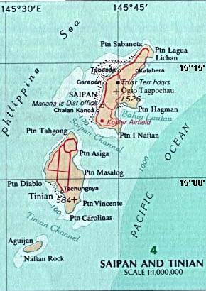
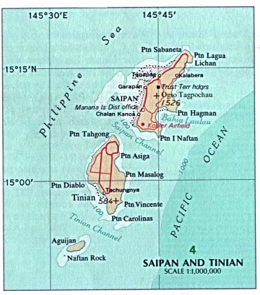
Map_Saipan_Tinian_islands_closer.jpg (pikisal 290 × 410, girman fayil: 31 KB, irin MIME: image/jpeg)
Taƙaici
| Bayani |
English: Map of the islands of Saipan and Tinian in the Northern Mariana Islands along the Marianas Trench (east of China and the Philippines). |
| Rana | |
| Masomi |
Derived by cropping US Government (USNA) map: http://www.lib.utexas.edu/maps/australia/saipan_tinian_islands.jpg linked as being a US National Atlas (1970) map on related webpage: http://www.lib.utexas.edu/maps/northern_mariana_islands.html . |
| Marubucin |
map:US Geological Survey |
| Other versions |
 |
Lasisi
The map is public domain, derived by User:Wikid77 from a USNA image (in JPEG format).
This image is in the public domain in the United States because it only contains materials that originally came from the United States Geological Survey, an agency of the United States Department of the Interior. For more information, see the official USGS copyright policy.
|
Tarihin fayil
Ku latsa rana/lokaci ku ga fayil yadda yake a wannan lokaci
| Rana/Lokaci | Wadar sufa | Kusurwowi | Ma'aikaci | Bahasi | |
|---|---|---|---|---|---|
| na yanzu | 14:32, 7 ga Maris, 2008 | | 290 × 410 (31 KB) | Wikid77 | initial upload |
Amfani da fayil
Wadannan shafi na amfani wannan fayil:
Amfanin fayil a ko'ina
Wadannan sauran wikis suna amfani da fayil din anan
- Amfani a kan cs.wikipedia.org
- Amfani a kan el.wikipedia.org
- Amfani a kan en.wikipedia.org
- Amfani a kan eu.wikipedia.org
- Amfani a kan fa.wikipedia.org
- Amfani a kan hi.wikipedia.org
- Amfani a kan id.wikipedia.org
- Amfani a kan it.wikipedia.org
- Amfani a kan ka.wikipedia.org
- Amfani a kan ml.wikipedia.org
- Amfani a kan nl.wikipedia.org
- Amfani a kan ps.wikipedia.org
- Amfani a kan pt.wikipedia.org
- Amfani a kan sl.wikipedia.org
- Amfani a kan tr.wikipedia.org
- Amfani a kan uk.wikipedia.org
- Amfani a kan vi.wikipedia.org