
Fayil:Rennel map 1799.png

Hoton asali (pikisal 1,318 × 1,060, girman fayil: 335 KB, irin MIME: image/png)
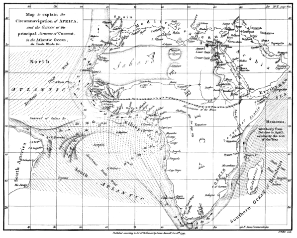
| Bayani | Map of the currents in the Atlantic and Indian Ocean | ||||
| Rana | |||||
| Masomi | "The geographical system of herodotus ..." by James Rennell, London 01. January 1800 | ||||
| Marubucin | James Rennell | ||||
| Izini (Sake amfani da wannan fayil) |
|
||||
Tarihin fayil
Ku latsa rana/lokaci ku ga fayil yadda yake a wannan lokaci
| Rana/Lokaci | Wadar sufa | Kusurwowi | Ma'aikaci | Bahasi | |
|---|---|---|---|---|---|
| na yanzu | 15:07, 13 ga Faburairu, 2018 | | 1,318 × 1,060 (335 KB) | Shyamal | Contrast |
| 17:28, 4 ga Augusta, 2005 |  | 1,318 × 1,060 (4.01 MB) | Kl833x9~commonswiki | Map of the currents in the Atlantic and Indian Ocean Created by James Rennell 1799 Source: Copy from Book "The geographical system of herodotus ..." by James Rennell, London 01. January 1800 {{PD}} |
Amfani da fayil
Babu shafuka da suke amfani da fayil din nan.
Amfanin fayil a ko'ina
Wadannan sauran wikis suna amfani da fayil din anan
- Amfani a kan ar.wikipedia.org
- Amfani a kan ary.wikipedia.org
- Amfani a kan bn.wikipedia.org
- Amfani a kan br.wikipedia.org
- Amfani a kan ca.wikipedia.org
- Amfani a kan da.wikipedia.org
- Amfani a kan da.wikibooks.org
- Amfani a kan de.wikipedia.org
- Amfani a kan en.wikipedia.org
- Amfani a kan es.wikipedia.org
- Amfani a kan fa.wikipedia.org
- Amfani a kan fa.wikibooks.org
- Amfani a kan hif.wikipedia.org
- Amfani a kan hi.wikipedia.org
- Amfani a kan id.wikipedia.org
- Amfani a kan ja.wikipedia.org
- Amfani a kan mk.wikipedia.org
- Amfani a kan nl.wikipedia.org
- Amfani a kan pnb.wikipedia.org
- Amfani a kan ta.wikipedia.org
- Amfani a kan tr.wikipedia.org
- Amfani a kan ur.wikipedia.org
- Amfani a kan www.wikidata.org