
File:Volcano Map.png
Babu wata babbar saƙa.
Volcano_Map.png (pikisal 611 × 273, girman fayil: 22 KB, irin MIME: image/png)
Taƙaici
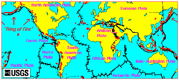
English: Volcano Map from the USGS site.
Lasisi
This image is in the public domain in the United States because it only contains materials that originally came from the United States Geological Survey, an agency of the United States Department of the Interior. For more information, see the official USGS copyright policy.
|
Tarihin fayil
Ku latsa rana/lokaci ku ga fayil yadda yake a wannan lokaci
| Rana/Lokaci | Wadar sufa | Kusurwowi | Ma'aikaci | Bahasi | |
|---|---|---|---|---|---|
| na yanzu | 17:14, 29 Satumba 2008 | | 611 × 273 (22 KB) | Rvd4life | Volcano Map {{PD-USGov-Interior-USGS}} <!--{{ImageUpload|basic}}--> |
Amfani da fayil
Wadannan shafi na amfani wannan fayil:
Amfanin fayil a ko'ina
Wadannan sauran wikis suna amfani da fayil din anan
- Amfani a kan bn.wikipedia.org
- Amfani a kan bs.wikipedia.org
- Amfani a kan cs.wikipedia.org
- Amfani a kan de.wikipedia.org
- Amfani a kan en.wikipedia.org
- Amfani a kan et.wikipedia.org
- Amfani a kan ga.wikipedia.org
- Amfani a kan gu.wikipedia.org
- Amfani a kan he.wikipedia.org
- Amfani a kan hr.wikipedia.org
- Amfani a kan pnb.wikipedia.org
- Amfani a kan ru.wikipedia.org
- Amfani a kan sh.wikipedia.org
- Amfani a kan simple.wikipedia.org
- Amfani a kan ta.wikipedia.org
- Amfani a kan th.wikipedia.org
- Amfani a kan uk.wikipedia.org
- Amfani a kan ur.wikipedia.org